File:M106Ch06Fig02.jpg
Original file (489 × 824 pixels, file size: 63 KB, MIME type: image/jpeg)
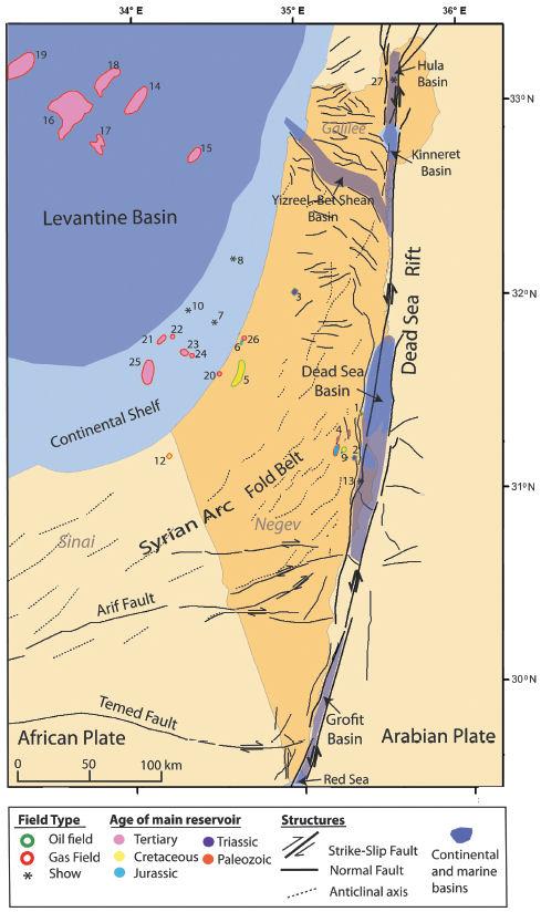
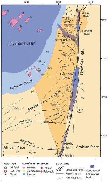
Map showing the main tectonic elements and petroleum occurrences of Israel. The two most prominent tectonic features are the Levantine Basin and Margin in the west and the Dead Sea rift in the east. Most of the hydrocarbon accumulations found in Israel are associated with these two tectonic provinces. Other important structural elements are the Syrian Arc fold belt in central and southern Israel, the Sinai-Negev dextral, strike-slip faults, and the normal fault system of the Galilee. Numbers refer to oil fields and hydrocarbon shows detailed in Table 1. 50 km (31.1 mi). From Gardosh, Michael A., and Eli Tannenbaum, 2014, The petroleum systems of Israel, in L. Marlow, C. Kendall, and L. Yose, eds., Petroleum systems of the Tethyan region: AAPG Memoir 106, p. 179-216.
File history
Click on a date/time to view the file as it appeared at that time.
| Date/Time | Thumbnail | Dimensions | User | Comment | |
|---|---|---|---|---|---|
| current | 15:25, 23 February 2016 | | 489 × 824 (63 KB) | Molyneux (talk | contribs) | Map showing the main tectonic elements and petroleum occurrences of Israel. The two most prominent tectonic features are the Levantine Basin and Margin in the west and the Dead Sea rift in the east. Most of the hydrocarbon accumulations found in Israel... |
You cannot overwrite this file.
File usage
The following page uses this file: