File:M106Ch06Fig03.jpg
Jump to navigation
Jump to search

Size of this preview: 458 × 600 pixels. Other resolutions: 183 × 240 pixels | 700 × 917 pixels.
Original file (700 × 917 pixels, file size: 76 KB, MIME type: image/jpeg)
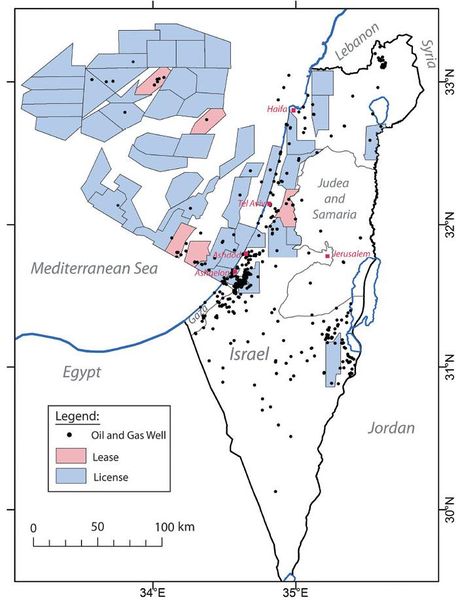
Map showing the location of oil and gas wells and active petroleum rights (licenses and leases) in Israel. The information in the map is updated to April 2012 (adapted from information in the Israel Ministry of Energy and Water Resources website). 50 km (31.1 mi). From Gardosh, Michael A., and Eli Tannenbaum, 2014, The petroleum systems of Israel, in L. Marlow, C. Kendall, and L. Yose, eds., Petroleum systems of the Tethyan region: AAPG Memoir 106, p. 179-216.
File history
Click on a date/time to view the file as it appeared at that time.
| Date/Time | Thumbnail | Dimensions | User | Comment | |
|---|---|---|---|---|---|
| current | 15:29, 23 February 2016 | | 700 × 917 (76 KB) | Molyneux (talk | contribs) | Map showing the location of oil and gas wells and active petroleum rights (licenses and leases) in Israel. The information in the map is updated to April 2012 (adapted from information in the Israel Ministry of Energy and Water Resources website). 50 k... |
You cannot overwrite this file.
File usage
The following page uses this file: