File:M106Ch12Fig01.jpg
Jump to navigation
Jump to search


Size of this preview: 571 × 600 pixels. Other resolutions: 229 × 240 pixels | 700 × 735 pixels.
Original file (700 × 735 pixels, file size: 96 KB, MIME type: image/jpeg)
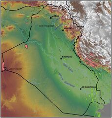
Topographic map of Iraq, showing major cities and rivers, along with major oil and gas fields. Points of high elevation are indicated. From Grabowski Jr., G. J., 2014, Iraq, in L. Marlow, C. Kendall, and L. Yose, eds., Petroleum systems of the Tethyan region: AAPG Memoir 106, p. 379-467.
File history
Click on a date/time to view the file as it appeared at that time.
| Date/Time | Thumbnail | Dimensions | User | Comment | |
|---|---|---|---|---|---|
| current | 20:15, 11 May 2016 | | 700 × 735 (96 KB) | Molyneux (talk | contribs) | Topographic map of Iraq, showing major cities and rivers, along with major oil and gas fields. Points of high elevation are indicated. From Grabowski Jr., G. J., 2014, Iraq, in L. Marlow, C. Kendall, and L. Yose, eds., Petroleum systems of the Tethyan ... |
You cannot overwrite this file.
File usage
The following page uses this file: