File:M114CH03FG01.jpg

Original file (691 × 944 pixels, file size: 147 KB, MIME type: image/jpeg)
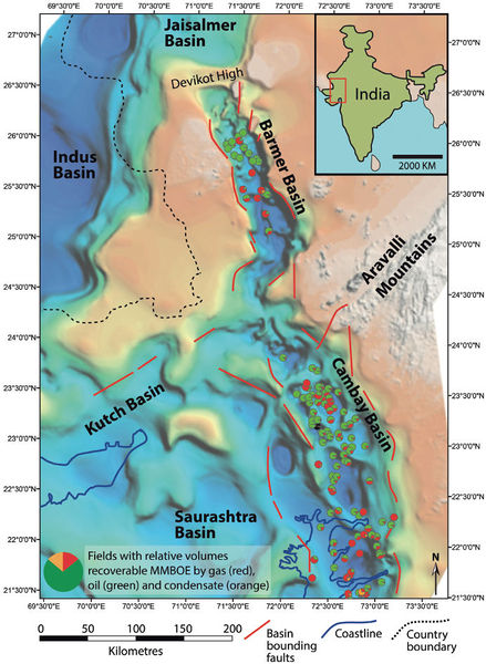
Location of the Barmer Basin in the context of the onshore sedimentary basins in northwestern India displayed on a map of depth to top basement (red is shallow, blue is deep; color scales are generalized to reflect deep versus shallow depths to top of basement derived from gravity, magnetic, and well data; based on Dolson et al., 2015). Data points show the distribution of discovered fields in the Barmer and Cambay basins and their relative phase ratios of gas, oil, and condensate. From AAPG Memoir 114: Petroleum Systems Analysis—Case Studies, [Chapter 03].
File history
Click on a date/time to view the file as it appeared at that time.
| Date/Time | Thumbnail | Dimensions | User | Comment | |
|---|---|---|---|---|---|
| current | 17:46, 4 January 2019 | | 691 × 944 (147 KB) | Molyneux (talk | contribs) | Location of the Barmer Basin in the context of the onshore sedimentary basins in northwestern India displayed on a map of depth to top basement (red is shallow, blue is deep; color scales are generalized to reflect deep versus shallow depths to top of ... |
You cannot overwrite this file.
File usage
The following page uses this file: