File:M114CH03FG03.jpg
M114CH03FG03.jpg (700 × 600 pixels, file size: 112 KB, MIME type: image/jpeg)
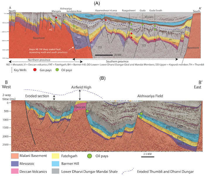
Representative seismic sections with geological interpretation overlay illustrating the main aspects of basin structure. (A) North–south line A–A’. The shallow, inverted northern portion of the basin has never been buried as deeply as the south and is characterized by the presence of large, tilted fault blocks with very shallow Fatehgarh and Barmer Hill Formation reservoirs. By contrast, reservoirs in the southern part of the basin are at burial depths present day of ca. 3 km and have not been significantly inverted. The large, deep fault northwest of the Vandana area is a major hinge line, controlling deposition through time and a pivot point north across which there has been strong inversion. (B) West–east line B–B’ showing asymmetric half graben structure and the steep-sided nature of the Airfield High. From AAPG Memoir 114: Petroleum Systems Analysis—Case Studies, [Chapter 03].
File history
Click on a date/time to view the file as it appeared at that time.
| Date/Time | Thumbnail | Dimensions | User | Comment | |
|---|---|---|---|---|---|
| current | 17:49, 4 January 2019 | | 700 × 600 (112 KB) | Molyneux (talk | contribs) | Representative seismic sections with geological interpretation overlay illustrating the main aspects of basin structure. (A) North–south line A–A’. The shallow, inverted northern portion of the basin has never been buried as deeply as the south a... |
You cannot overwrite this file.
File usage
The following page uses this file: