File:M91Ch11FG71.JPG
Jump to navigation
Jump to search

Size of this preview: 763 × 600 pixels. Other resolutions: 305 × 240 pixels | 800 × 629 pixels.
Original file (800 × 629 pixels, file size: 79 KB, MIME type: image/jpeg)
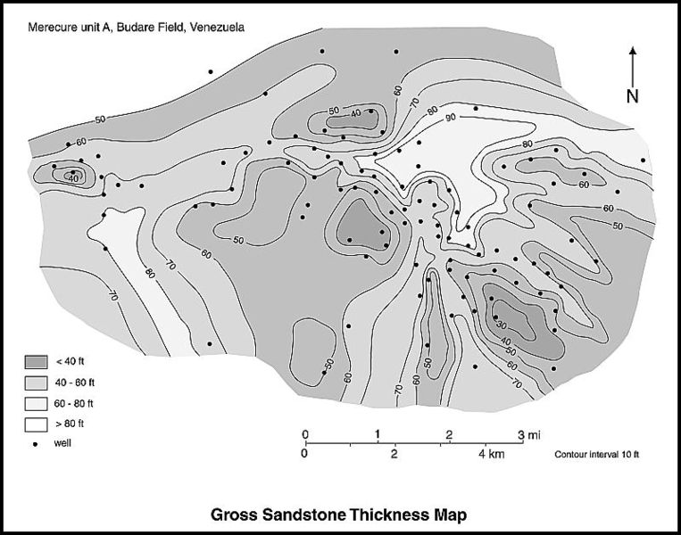
A gross sandstone thickness map can give an idea of the depositional dip and strike of the sedimentary system. In the Budare field of Venezuela, north–south strike elements correspond to distributary channels in the bottom part of the map. An east–west arcuate depositional element in the north of the map corresponds to a wave-dominated delta front (from Hamilton et al., 2002). From Shepherd, M., 2009, Lithofacies maps, in M. Shepherd, Oil field production geology: AAPG Memoir 91, p. 93-98.
File history
Click on a date/time to view the file as it appeared at that time.
| Date/Time | Thumbnail | Dimensions | User | Comment | |
|---|---|---|---|---|---|
| current | 15:48, 27 April 2015 | | 800 × 629 (79 KB) | Molyneux (talk | contribs) | A gross sandstone thickness map can give an idea of the depositional dip and strike of the sedimentary system. In the Budare field of Venezuela, north–south strike elements correspond to distributary channels in the bottom part of the map. An east–... |
You cannot overwrite this file.
File usage
The following 2 pages use this file: