Difference between revisions of "Covenant field"
Cwhitehurst (talk | contribs) |
Cwhitehurst (talk | contribs) |
||
| Line 1: | Line 1: | ||
| − | |||
| − | |||
| − | |||
| − | |||
The Covenant Field is an oil field located in Sevier County, Utah. The field was discovered in 2004 by Wolverine Oil and Gas, in the Kings Meadow Ranches #17-1 well when it encountered oil in the Navajo Formation. Credits for the geologic ideas behind the discovery have been attributed to Dr. Douglas K. Strickland. The work leading to this discovery is has been summarized by Strickland in several presentations at AAPG conferences.<ref name=Strickland05>Strickland, D., K. R. Johnson, J. P. Vrona, D. D. Schelling, and D. A. Wavrek, 2005, [http://www.searchanddiscovery.com/documents/2005/av/strickland/ndx_strickland.pdf Structural architecture, petroleum systems, and geological implications for the Covenant field discovery, Sevier County, Utah]: AAPG Search and Discovery Article No. 110014</ref><ref>Strickland, D., 2009, [http://player.piksel.com/player.php?v=bl432u69 Conventional Wisdom: A Different Approach Exploration in the Central Utah Thrust Belt]: Audio-Video presentations at 2009 AAPG Annual Convention, Denver, Colorado, June 7-10.</ref> | The Covenant Field is an oil field located in Sevier County, Utah. The field was discovered in 2004 by Wolverine Oil and Gas, in the Kings Meadow Ranches #17-1 well when it encountered oil in the Navajo Formation. Credits for the geologic ideas behind the discovery have been attributed to Dr. Douglas K. Strickland. The work leading to this discovery is has been summarized by Strickland in several presentations at AAPG conferences.<ref name=Strickland05>Strickland, D., K. R. Johnson, J. P. Vrona, D. D. Schelling, and D. A. Wavrek, 2005, [http://www.searchanddiscovery.com/documents/2005/av/strickland/ndx_strickland.pdf Structural architecture, petroleum systems, and geological implications for the Covenant field discovery, Sevier County, Utah]: AAPG Search and Discovery Article No. 110014</ref><ref>Strickland, D., 2009, [http://player.piksel.com/player.php?v=bl432u69 Conventional Wisdom: A Different Approach Exploration in the Central Utah Thrust Belt]: Audio-Video presentations at 2009 AAPG Annual Convention, Denver, Colorado, June 7-10.</ref> | ||
==Structure== | ==Structure== | ||
| + | <gallery mode=packed heights=300px widths=300px> | ||
| + | CovenantFieldFig3.jpeg|{{figure number|1}}a) Inset map of the western United States showing the location of Utah. (b) Shaded relief map of Utah showing the location of the overthrust belt of northeastern Utah and southwestern Wyoming and the Covenant oil field, including tectonic elements. SR = San Rafael swell; KU = Kaibab uplift; MU = Monument uplift; WF = Waterpocket fold; A = Absaroka thrust fault. (c) Covenant field locality map of central Utah. From Parry, et. Al 2009 | ||
| + | CovenantFieldFig1.png|{{figure number|2}}Generalized stratigraphic column of rock units the Covenant field area. The Lower Jurassic Navajo Sandstone is the reservoir, while the overlying Middle Jurassic Twin Peaks Limestone and Arapien Shale form the cap rocks or seal for the field. From Parry, et.al 2009. | ||
| + | CovenantFieldFig2.png|thumb|400px|{{figure number|3}}A NW-SE trending cross section showing the Covenant oil field structure, Paxton and Gunnison-Salina thrust, and normal faults bounding Sevier Valley. Note that OWC = oil-water contact for the covenant field. See Figure 2 for the key to the geologic symbols. From Parry, et. Al 2009 | ||
| + | </gallery> | ||
The Covenant field is located in the central Utah thrust belt. Chidsey, et al.<ref name=Chidsey>Chidsey, T. C., Jr., J. S. DeHamer, E. E. Hartwick, K. R. Johnson, D. D. Schelling, D. A. Sprinkel, D. K. Strickland, J. P. Vrona, & D. A. Wavrek, 2007, Central Utah: Diverse Geology of a Dynamic Landscape, Petroleum Geology of Covenant Oil Field, Central Utah Thrust Belt, pp. 273-296</ref> describe the Covenant field trap as an “elongate, symmetric, northeast-trending, fault-propagation/fault-bend anticline with nearly 800 feet (270m) of structural closure with a 450-foot (150M) oil column. The oil-charged Navajo reservoir covers about 960 acres.” The structure is related to movement along the Gunnison-Salina thrust and Paxton thrust fault and part of the larger Utah thrust belt province, this is outlined in greater detail by Chidsey et al.<ref name=Chidsey /> | The Covenant field is located in the central Utah thrust belt. Chidsey, et al.<ref name=Chidsey>Chidsey, T. C., Jr., J. S. DeHamer, E. E. Hartwick, K. R. Johnson, D. D. Schelling, D. A. Sprinkel, D. K. Strickland, J. P. Vrona, & D. A. Wavrek, 2007, Central Utah: Diverse Geology of a Dynamic Landscape, Petroleum Geology of Covenant Oil Field, Central Utah Thrust Belt, pp. 273-296</ref> describe the Covenant field trap as an “elongate, symmetric, northeast-trending, fault-propagation/fault-bend anticline with nearly 800 feet (270m) of structural closure with a 450-foot (150M) oil column. The oil-charged Navajo reservoir covers about 960 acres.” The structure is related to movement along the Gunnison-Salina thrust and Paxton thrust fault and part of the larger Utah thrust belt province, this is outlined in greater detail by Chidsey et al.<ref name=Chidsey /> | ||
| Line 14: | Line 15: | ||
The significance of the Covenant discovery, summarized by Chidsey,<ref name=Chidsey /> is that it proved that the central Utah thrust belt contained the right components of trap, reservoir, seal, source and migration history for large accumulations of oil to occur. In reflecting on the exploration work leading to its discovery Strickland noted that the Covenant field disproved many aspects of conventional wisdom as to the exploration potential of the region.<ref name=Strickland05 /> | The significance of the Covenant discovery, summarized by Chidsey,<ref name=Chidsey /> is that it proved that the central Utah thrust belt contained the right components of trap, reservoir, seal, source and migration history for large accumulations of oil to occur. In reflecting on the exploration work leading to its discovery Strickland noted that the Covenant field disproved many aspects of conventional wisdom as to the exploration potential of the region.<ref name=Strickland05 /> | ||
| − | [[File: | + | [[File:StricklandCovSS.png|thumb|left|300px|Still of Strickland giving his talk on the discovery of the Covenant field in 2005.]] |
| + | {{clear}} | ||
==Related reading== | ==Related reading== | ||
Revision as of 13:29, 2 September 2015
The Covenant Field is an oil field located in Sevier County, Utah. The field was discovered in 2004 by Wolverine Oil and Gas, in the Kings Meadow Ranches #17-1 well when it encountered oil in the Navajo Formation. Credits for the geologic ideas behind the discovery have been attributed to Dr. Douglas K. Strickland. The work leading to this discovery is has been summarized by Strickland in several presentations at AAPG conferences.[1][2]
Structure[edit]

Figure 1 a) Inset map of the western United States showing the location of Utah. (b) Shaded relief map of Utah showing the location of the overthrust belt of northeastern Utah and southwestern Wyoming and the Covenant oil field, including tectonic elements. SR = San Rafael swell; KU = Kaibab uplift; MU = Monument uplift; WF = Waterpocket fold; A = Absaroka thrust fault. (c) Covenant field locality map of central Utah. From Parry, et. Al 2009
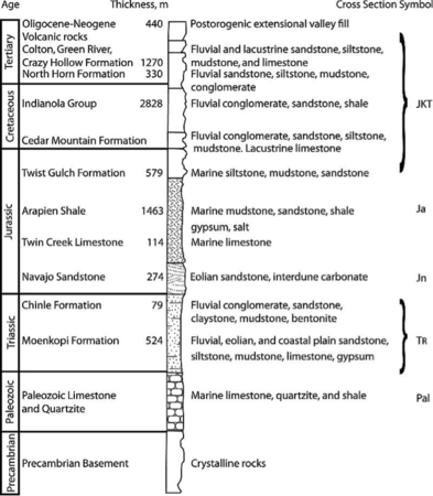
Figure 2 Generalized stratigraphic column of rock units the Covenant field area. The Lower Jurassic Navajo Sandstone is the reservoir, while the overlying Middle Jurassic Twin Peaks Limestone and Arapien Shale form the cap rocks or seal for the field. From Parry, et.al 2009.
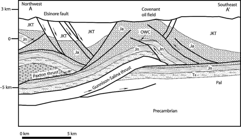
Figure 3 A NW-SE trending cross section showing the Covenant oil field structure, Paxton and Gunnison-Salina thrust, and normal faults bounding Sevier Valley. Note that OWC = oil-water contact for the covenant field. See Figure 2 for the key to the geologic symbols. From Parry, et. Al 2009


The Covenant field is located in the central Utah thrust belt. Chidsey, et al.[3] describe the Covenant field trap as an “elongate, symmetric, northeast-trending, fault-propagation/fault-bend anticline with nearly 800 feet (270m) of structural closure with a 450-foot (150M) oil column. The oil-charged Navajo reservoir covers about 960 acres.” The structure is related to movement along the Gunnison-Salina thrust and Paxton thrust fault and part of the larger Utah thrust belt province, this is outlined in greater detail by Chidsey et al.[3]
Reservoir[edit]
The primary (as of 2007) reservoir in the Covenant Field is the Navajo Sandstone Early Jurassic (Toarcian) eolian sandstone. Parry, Chan, and Nash[4] outlined diagenetic charchteristics of the Navajo Sandstone from cores in the Covenant field. As of April 2015 the field had 24 active wells, and had produced a cumulative 21,443,660 barrels of oil.[5]
Significance[edit]
The significance of the Covenant discovery, summarized by Chidsey,[3] is that it proved that the central Utah thrust belt contained the right components of trap, reservoir, seal, source and migration history for large accumulations of oil to occur. In reflecting on the exploration work leading to its discovery Strickland noted that the Covenant field disproved many aspects of conventional wisdom as to the exploration potential of the region.[1]

Related reading[edit]
- Brown, D., 2008, Tricky Geology Is Utah Hallmark: AAPG Explorer
- Hartwick, E. E., 2010, Eolian Architecture of Sandstone Reservoirs in the Covenant Field, Sevier County, Utah
- Strickland, D., 2009, Conventional Wisdom: A Different Approach Exploration in the Central Utah Thrust Belt
References[edit]
- ↑ 1.0 1.1 Strickland, D., K. R. Johnson, J. P. Vrona, D. D. Schelling, and D. A. Wavrek, 2005, Structural architecture, petroleum systems, and geological implications for the Covenant field discovery, Sevier County, Utah: AAPG Search and Discovery Article No. 110014
- ↑ Strickland, D., 2009, Conventional Wisdom: A Different Approach Exploration in the Central Utah Thrust Belt: Audio-Video presentations at 2009 AAPG Annual Convention, Denver, Colorado, June 7-10.
- ↑ 3.0 3.1 3.2 Chidsey, T. C., Jr., J. S. DeHamer, E. E. Hartwick, K. R. Johnson, D. D. Schelling, D. A. Sprinkel, D. K. Strickland, J. P. Vrona, & D. A. Wavrek, 2007, Central Utah: Diverse Geology of a Dynamic Landscape, Petroleum Geology of Covenant Oil Field, Central Utah Thrust Belt, pp. 273-296
- ↑ Parry, W. T., M. A. Chan, & B. P. Nash, 2009, Diagenetic characteristics of the Jurassic Navajo Sandstone in the Covenant oil field, central Utah thrust belt: AAPG Bulletin, vol. 93, no. 8, p. 1039-1061.
- ↑ Field Production Reports, Utah