Difference between revisions of "Karst topography"
Cwhitehurst (talk | contribs) |
Cwhitehurst (talk | contribs) |
||
| Line 50: | Line 50: | ||
* Tunnels and bridges nature according to Von Engeln 1942 an underground passageway formed by leaching and erosion by the flow of groundwater or underground Form the rest of dissolution | * Tunnels and bridges nature according to Von Engeln 1942 an underground passageway formed by leaching and erosion by the flow of groundwater or underground Form the rest of dissolution | ||
* Cone karst is cone-shaped karst hills, steep slopes and surrounded by a depression which is usually referred to as a star. Cone karst often referred to as kegel karst. | * Cone karst is cone-shaped karst hills, steep slopes and surrounded by a depression which is usually referred to as a star. Cone karst often referred to as kegel karst. | ||
| − | * Tower karst according to Ritter in 1978 the tower karst is the rest of dissolution and erosion of the hill-shaped tower with a steep slope, upright or hanging, separated from one another and surrounded by alluvial plains. | + | * Tower karst according to Ritter in 1978 the tower karst is the rest of dissolution and erosion of the hill-shaped tower with a steep slope, upright or hanging, separated from one another and surrounded by [[alluvial]] plains. |
* Mogote is a steep hill which is the residual leaching and erosion, generally surrounded by alluvial plains were nearly flat (flat). | * Mogote is a steep hill which is the residual leaching and erosion, generally surrounded by alluvial plains were nearly flat (flat). | ||
Revision as of 14:48, 6 November 2015
| Wiki Write-Off Entry | |
|---|---|

| |
| Student Chapter | Universitas Diponegoro |
| Competition | June 2015 |
Karst environment
Karst is terrain in which soluble rocks are altered above and below ground by the dissolving action of water and that bears distinctive characteristics of relief and drainage. Karst has unique hydrology condition, this condition is caused of karst composed of soluble lithology and the lithology has good condition in secondary porosity.
Karst has unique characteristic, usually in the area which as karst landform comprising a lot of cavity in surface, and the famous characteristic is the type of river, that is multibasinal river, and in karst usually has cave in subsurface.
Karst is not only occur in area which comprising dominant carbonate rock, but also karst can occur in the other are which comprising not dominant carbonate rock but should dominant in soluble rock.
Karst classification
Karst topography has found in many places in the world with a lot of type, and all types of karst are classified into three classification :
- Cvijic classification based on development
- Gevozdeckij classification based on morphology
- Sweeting classification based on climate
Cvijic classification
Cvijic devide karst topography into three group, these are holokarst, merokarst, and transitionkarst.
- Holokarst can mentioned as complete karst develops in areas included entirely of soluble carbonate rock. It is characterized by the vast, bare, and rocky land, without arable land and with or without present of veregetation.
- Merokarst can mentioned as incomplete karst has many properties of nonkarst regions. The karst phenomena in these regions are in frequent and karstifiction occurs in lower depths. Carbonate sediments are covered with arable soil and with vegetation. Merokarst usually too called as covered karst.
- transitional type the degree of karstification in this type of karst is between holokarst and merokarst. The transitional type is usually formed in limestone isolated by impermeable and less soluble sediments.
Gevozdeckij classification
Gevozdeckij classification divided karst type into bare karst, covered karst, soddy karst, buried karst, tropical karst, and permafrost karst. Actually bare karst is same with holokarst, covered karst occur if carbonate rock covered by alluvium deposit. Soddy karst or soil covered karst is karst that develop in limestone that covered by soil or terra that produced by limestone dissolution. Buried karst is karst that covered by other rocks so the morphology is unidentified and only can identify by drill data. Tropical karst of cone karst is karst that only occur in tropical area. Permafrost karst is karst that only occur in snow area.
Sweeting classification
Karst according to Sweeting is classified as true karst, fluviokarst, glaciokarst, tropical, arid and semiarid karst, this classification is based on climate. True karst is perfect karst and called as holokarst, true karst should as doline karst that caused of vertical dissolution., all karst that not doline type mentioned as deviant, example of true karst is dinaric karst. Fluviokarst is formed by combination between fluvial process and dissolution process, fluviokarst usually occur in are that consist of limestone which passed by allogenic river. Glasiokarst is karst that formed cause karstification affecter by glacial process and usually occur in area that comprising limestone. Nival karst is karst that formed caused of karstification process by snow in glacial environment and periglacial. Tropical karst is different with karst that occure in warm climate, this type caused by great precipitation and evaporation. Kegelkarst is characterized by accumulation of continue domes, space between one dome to another dome make basin and the basin is look like star and mentioned as cockpit.
Karst topography
Karst Topography is devided into two that is macro topography and micro topography. Von Engeln (1942) mentioned the certain condition to support formation of topography karst, there are :
- Soluble and near surface
- Massif, thick, and buried
- Medium to high accumulation rainfall
- Surrounded by valley
Micro topography
- Lapies is uneven shape in limestone surface caused of dissolution or other process.
- Karst split is dissolution space formed in surface, karst split actuallt developed from karst runnel, if the number of karst Runnel lot and intersecting it will form a karst split.
- Speleothem an ornament found in karst cave, which is commonly found that stalagtit hanging in the roof of the cave, and stalagmites at the bottom of the cave.
- Fitokarst is an undulating surface, with vent holes interconnected.
Macro topography
- Dolina is the result of condensation of depression covered with diameters ranging from a few meters to several kilometers, its depth reaches hundreds of meters to several kilometers, its depth reaches hundreds of meters and a round or oval shape.
- uvala is a topography that is formed when an adjacent Surupan Surupan develop so interconnected and form a large depression in the ground floor is bumpy.
- Polje according cvijic 1985 is a karst landform elements that have a basin wide, flat base, drainage krastik, elongated shape parallel to local structures, basic Polje have tertiary rock layers.
- karst window according Twidale 1976 was a hole in the roof of the cave that connects the chamber with the air outside the cave formed by the roof of the cave collapsed. karst valleys are large valleys or grooves contained in karst land. This valley is formed by the flow of surface water that eroded the rocks in its path.
- Cave is underground rooms that can be reached from the surface and large enough when entered by a human
- Tunnels and bridges nature according to Von Engeln 1942 an underground passageway formed by leaching and erosion by the flow of groundwater or underground Form the rest of dissolution
- Cone karst is cone-shaped karst hills, steep slopes and surrounded by a depression which is usually referred to as a star. Cone karst often referred to as kegel karst.
- Tower karst according to Ritter in 1978 the tower karst is the rest of dissolution and erosion of the hill-shaped tower with a steep slope, upright or hanging, separated from one another and surrounded by alluvial plains.
- Mogote is a steep hill which is the residual leaching and erosion, generally surrounded by alluvial plains were nearly flat (flat).
Karstification
Kartsification or formation process of karst morphology dominated by dissolves process. Limestone dissolve process begins with CO2 that dissolved in water and form H2CO3. Dissolve H2CO3 is unstable and dissolve become H- and HCO32-. These H- ions furthermore dissolve CaCO3 become Ca2+ and HCO32-

Karstification Factors
Karstification influenced by two main factors that is control factor and simulation factor. Control factor determine which karstification can develop or not and simulation factior determine velocity and completeness of karstification process

Control factors
- Dissolvable rock, Compact, Thick, and have many fissure
- Enough fall of rain (>250 mm/year)
- Exposed rock on elevated that possible develop water circulation/ vertical drainage
Simulation Factor
- Temperature
- Closing forest
Rock that composed high CaCO3 is dissolvable. Higher CaCO3 composition, karst morphology will develop. The compaction of rock determines stability of karst morphology after dissolution. If soft rock, then every visible karst that formed like karen and hill will be fast to vanish because of dissolution process itself or erosion and mass flow, therefore karst visibility cant developed. Thickness determines the form of vertical water circulation more, without thick layer, vertical water circulation that is requirements of karstification can ongoing. Without vertical circulation, process that ongoing is lateral flow like on surface rivers and close basins can’t form. Rock fissures are way to enter water formed vertical drainage and developing Sub-surface River and concentrate dissolution
Fall of rain is main dissolution media in karstification process. Higher fall of rain, higher dissolution media, until level of dissolution that occur in limestone becomes higher. Elevation of limestone that exposed in surface determines vertical circulation/drainage.
Although limestone have thick layer but only exposed about several meters from sea level, karstification will never occur. Vertical drainage will occur when distance between surface of limestone with water surface or basement of limestone bigger. Higher exposed limestone surface, higher distance between surface of limestone with water surface and better vertical water circulation, and also more intensive karstification process.

Temperature drives karstification process primiliarly conncection with organism activity. Place with warm temperature such as in tropical area is an ideal place for organism that produce CO2 in ground. Temperature determines evaporation, higher temperature will impact in higher evaporation and as a result there will be recrystallization of carbonate solution in surface and near surface. This recrystallization will make amplification surface (case hardening) with the result that karst morphology that form can hold out for denudation process (erosion and mass flow)
The velocity of reaction so true as bigger in low temperature, because concentration of CO2 is higher than in low temperature. But dissolution level in tropical area is high because availability fall of rain that more abundant and higher organism activity. Closing forest is also simulator factor in developing because dense forest will have abundant CO2 in the ground as a result by reorganizing organic residues by microorganism. Higher CO2 concentrate in water will impact higher dissolution water level toward limestone. CO2 in atmosphere isn’t significantly having variation, as a result variation process of karstification depends on CO2 from organism activity.
Connection between CO2 concentrations with dissolution capacity toward limestone show in Figure 2 and Diagram 1.
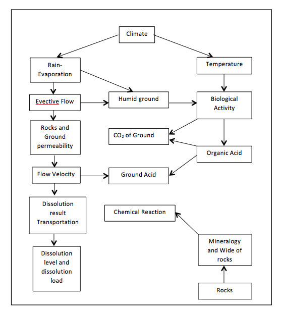
Diagram 1 Karstification factors and influence in dissolution process (Trudgil, 1985)

Karst aquifers

Karst Aquifers can describe as a geological formation that could store and flow ground water in moderate count in certain gradient (Acworth, 2001). So it means that karst formation could call as aquifers. Karst aquifers are characterized by a network of conduits and caves the conduits and caves drain the pore space between the limestone grains (intergranular or primary porosity) and the fractures (secondary porosity) formed by joints, bedding planes, and faults.
To study about karst aquifers system there are some method that should do such as geologic method, speleology, hydrologic methods, hydraulic methods, isotopics methods, tracer test, geophysical test, and modeling.
Hydrology system of karst aquifers

In karst topography, there are three component of water recharge area that is from karst formation itself, non-karst area and entrance water from above karst formation. Karst formation have three groundwater systems and between them have connection. At the beginning water enter from the fissure and in this phase diffuse system is dominated and then when solution process developed it will make a result a conduit system and impact increasing count of flow. In this phase call mixed groundwater system. And the system will be developed until conduit system is dominated and it is occur on mature phase of karst.
White[1]derived karst aquifers into three conceptual models that is Diffuse-flow karst aquifers that is dominated by diffuse system and low dissolution activity, usually it occur in unsolvable limestone such as dolomite. Free flow karst aquifer it is occur on mixed flow system, in this model groundwater controlled by distribution and direction from each path, and confined-flow karst aquifers its occur usually on beneath rocks that have low permeability and very controlled by layer above the aquifers.
References
Other sources
- Hugget, Richard John. 2007. Fundamentals of Geomorphology. Second Edition. Routledge, New York.
- Haryono. Eko, Nugroho Adji. Tjahyono. 2012. Geomorfologi dan Hidrologi Karst. UGM Press, Jogjakarta
- M. Karamouz, A. Ahmadi, M.Akhbari. 2012. “Groundwater Hydrology : Engineering, Planning, and Management”. UGM Press, Jogjakarta
- Geomorphology Lab. Assistant Team. 2014. Buku Panduan Praktikum Geomorfologi dan Geologi Foto. Universitas Diponegoro, Semarang