Difference between revisions of "File:M106Ch12Fig02.jpg"
Jump to navigation
Jump to search
(Bouguer gravity (right) and total magnetic field (left) maps of Iraq, from Jassim and Goff (2006), compiled by GEOSURV. The gravity map shows low values in the Zagros foldbelt and Mesopotamian foredeep due to the thick sedimentary section. Orientations...) |
(No difference)
|
Latest revision as of 20:26, 11 May 2016
Bouguer gravity (right) and total magnetic field (left) maps of Iraq, from Jassim and Goff (2006), compiled by GEOSURV. The gravity map shows low values in the Zagros foldbelt and Mesopotamian foredeep due to the thick sedimentary section. Orientations of features trend to the north and northwest in southern, western, and northwestern Iraq, interpreted in part to be caused by the structural grain of Precambrian accreted terrains. 200 km (124.3 mi). From Grabowski Jr., G. J., 2014, Iraq, in L. Marlow, C. Kendall, and L. Yose, eds., Petroleum systems of the Tethyan region: AAPG Memoir 106, p. 379-467.
File history
Click on a date/time to view the file as it appeared at that time.
| Date/Time | Thumbnail | Dimensions | User | Comment | |
|---|---|---|---|---|---|
| current | 20:26, 11 May 2016 | 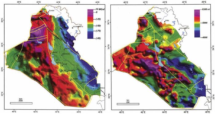 | 700 × 373 (52 KB) | Molyneux (talk | contribs) | Bouguer gravity (right) and total magnetic field (left) maps of Iraq, from Jassim and Goff (2006), compiled by GEOSURV. The gravity map shows low values in the Zagros foldbelt and Mesopotamian foredeep due to the thick sedimentary section. Orientations... |
You cannot overwrite this file.
File usage
The following page uses this file: