Difference between revisions of "The Neuquén Basin: Sequence Stratigraphy of Vaca Muerta Formation"
Cwhitehurst (talk | contribs) |
Cwhitehurst (talk | contribs) |
||
| Line 23: | Line 23: | ||
</gallery> | </gallery> | ||
| − | The Nequén Basin has a broadly triangular shape and is located between 32° and 40°S latitude on the eastern side of the Andes in Argentina and central Chile ([[:File:1.png|Figure 1]]). It covers an area of over | + | The Nequén Basin has a broadly triangular shape and is located between 32° and 40°S latitude on the eastern side of the Andes in Argentina and central Chile ([[:File:1.png|Figure 1]]). It covers an area of over 120,000 km<sup>2</sup> and comprises a continuous record of up to 4000 meters of stratigraphy.<ref name=Veiga_et_al>Veiga, G. D., L. A. Saplletti, J. A. Howell, and E. Schwarz, 2005, The Neuquén Basin, Argentina: A case study in sequence stratigraphy and basin dynamics: Geological Society (London) Special Publication 252</ref> This triangular basin is limited on its western margin by the Andean magmatic arc and on its southern and northeast margins by the cratonic areas of the North Patagonian Massif and the Sierra Pintada System, respectively ([[:File:1.png|Figure 1]]). This Late Triassic-Early [[Cenozoic]] succession includes continental and marine siliciclastics, carbonates and evaporites that accumulated under a variety of basin styles.<ref name=Veiga_et_al /> |
| − | The evolution and development of the Nequén Basin | + | The evolution and development of the Nequén Basin can be considered in three stages. |
| − | * Stage 1. Late Triassic-Early Jurassic: | + | * Stage 1. Late Triassic-Early Jurassic: Prior to the onset of subduction on its western margin, this part of Gondwana was characterized by large transcurrent fault systems. This led to extensional tectonics whitin the basin and the evolution of a series of narrow, isolated depocentres ([[:File:2.png|Figure 2]]).<ref>Manceda, R., & D. Figueroa, 1995, [http://archives.datapages.com/data/specpubs/memoir62/18manced/0369.htm Inversion of the Mesozoic Neuquén rift in the Malargue fold and thrust belt, Mendoza, Argentina], in: A. J. Tankard, S. R. Suarez, & H. J. Welsink (eds), Petroleum Basins of South America, [http://store.aapg.org/detail.aspx?id=476 AAPG Memoir 62], pp. 369-382.</ref><ref name=Vergani>Vergani, G. D., A. J. Tankard, H. J. Belotti, & H. J. Welsink, 1995, [http://archives.datapages.com/data/specpubs/memoir62/19vergan/0383.htm Tectonic evolution and paleogeography of the Neuquén Basin, Argentina], in: A. J. Tankard, R. Suárez Soruco & H. J. Welsink (eds), Petroleum Basins of South America, [http://store.aapg.org/detail.aspx?id=476 AAPG Memoir 62], pp. 383-402. </ref><ref>Franzese, J. R., & L. A. Spalletti, 2001, Late Triassic –early Jurassic continental extension in southwestern Gondwana: tectonic segmentation and pre-break up rifting: Journal of South American Earth Sciences, vol. 4, pp. 257-270.</ref> |
* Stage 2. Early Jurassic-Early Cretaceous: development of a steeply dipping, active subduction zone and the associated evolution of a magmatic arc along the western margin of Gondwana led to back-arc subsidence within the Neuquén Basin. This post-rift stage of basin development locally accounts for more tan 4000 meters of the basin fill ([[:File:2.png|Figure 2]]).<ref name=Vergani /> | * Stage 2. Early Jurassic-Early Cretaceous: development of a steeply dipping, active subduction zone and the associated evolution of a magmatic arc along the western margin of Gondwana led to back-arc subsidence within the Neuquén Basin. This post-rift stage of basin development locally accounts for more tan 4000 meters of the basin fill ([[:File:2.png|Figure 2]]).<ref name=Vergani /> | ||
* Stage 3. Late Cretaceous-[[Cenozoic]]: transition to a shallowly dipping subduction zone resulting in compression and flexural subsidence, asocciated with 45-57 km of cristal shortening<ref>Introcaso, A., M. C. Pacino, & H. Fraga, 1992. Gravity, isostasy and Andean crustal shortening between latitudes 30° and 35°S: Tectonophysics, 205, pp. 31-48.</ref><ref>Ramos, V.A., 1999, Evolución Tectónica de la Argentina, in: R. Caminos (ed.) Geología Argentina. Instituto de Geología y Recursos Minerales, Anales, 29, 715-759. </ref> and uplift of the foreland thrust belt ([[:File:2.png|Figure 2]]).<ref name=Veiga_et_al /> | * Stage 3. Late Cretaceous-[[Cenozoic]]: transition to a shallowly dipping subduction zone resulting in compression and flexural subsidence, asocciated with 45-57 km of cristal shortening<ref>Introcaso, A., M. C. Pacino, & H. Fraga, 1992. Gravity, isostasy and Andean crustal shortening between latitudes 30° and 35°S: Tectonophysics, 205, pp. 31-48.</ref><ref>Ramos, V.A., 1999, Evolución Tectónica de la Argentina, in: R. Caminos (ed.) Geología Argentina. Instituto de Geología y Recursos Minerales, Anales, 29, 715-759. </ref> and uplift of the foreland thrust belt ([[:File:2.png|Figure 2]]).<ref name=Veiga_et_al /> | ||
Revision as of 19:03, 13 March 2019
| Wiki Write-Off Entry | |
|---|---|

| |
| Student Chapter | UNLP: La Plata |
| Competition | June 2015 |
This basin located in the sector western center of Argentina includes at present the provinces of Neuquén and Mendoza, extending towards the north in the mountain range of Saint John and to the east, in the extra-Andean region of Río Negro and west of The Pampa. This basin takes supreme relevancy as its extraordinary exhibitions and finished sequences estratigráficas of the Mesozoico which sedimentary record overcomes 6 meters of thickness. Its connection with the Pacific Ocean suffered successive closings along its history, characteristic that joins a succession of episodes of relative changes of the sea level. The result was a complex distribution of sedimentary deposits that include marine and continental successions. It is one of the producing basins of more important hydrocarbons of the country.[1]
In 1892, Bodenbender[2] informally described for the first time the outcrops of the highly bituminous shales with oil shows in the nucleus of ammonites[3] and Weaver[4] formally adopted the name Vaca Muerta Formation for the most important source rock of the Neuquén Basin.
Within the stratigraphic column, overlies with sharp contact the continental deposits of the Tordillo and QuebradadelSapo formations denoting the Tithonian transgression. Nevertheless, in some areas it can overlay in angular discordance on different pre-Tithonian units.[3][5]
This formation comprises a set of sedimentitas mainly marine they be distant to sides and in less measurement sediment continetal deposited between the late low titoniano and valanginiano early. This age is verified based on biozone amonoideos , calciesferas and calpionélidos.[6]
This formation belongs to the Group Low and this Mendoza over the Formation Tordillo (deposits of fluvial, wind fan and lacustrine).
The Vaca Muerta Formation is considered the bedrock by excellence in the Neuquén basin, but in recent years gained greater importance as unconventional reservoir.
Tectonic Frame[edit]
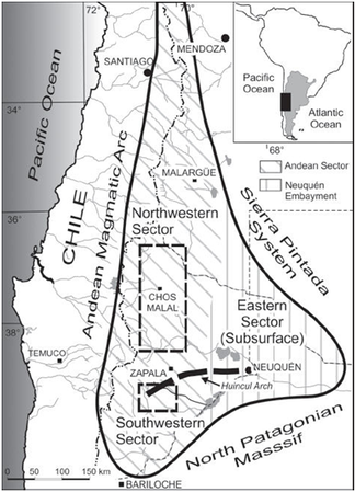
Figure 1 General map of the Neuquén Basin showing the location of main sites. Based on Spalletti & Veiga.[7]
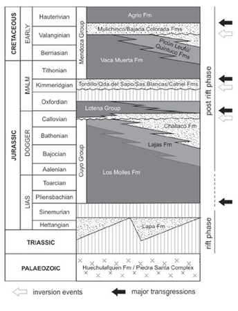
Figure 2 Jurassic and Lower Cretaceous lithostratigraphy of the Neuquén Basin. Based on Spalletti & Veiga.[7]
The Nequén Basin has a broadly triangular shape and is located between 32° and 40°S latitude on the eastern side of the Andes in Argentina and central Chile (Figure 1). It covers an area of over 120,000 km2 and comprises a continuous record of up to 4000 meters of stratigraphy.[8] This triangular basin is limited on its western margin by the Andean magmatic arc and on its southern and northeast margins by the cratonic areas of the North Patagonian Massif and the Sierra Pintada System, respectively (Figure 1). This Late Triassic-Early Cenozoic succession includes continental and marine siliciclastics, carbonates and evaporites that accumulated under a variety of basin styles.[8]
The evolution and development of the Nequén Basin can be considered in three stages.
- Stage 1. Late Triassic-Early Jurassic: Prior to the onset of subduction on its western margin, this part of Gondwana was characterized by large transcurrent fault systems. This led to extensional tectonics whitin the basin and the evolution of a series of narrow, isolated depocentres (Figure 2).[9][10][11]
- Stage 2. Early Jurassic-Early Cretaceous: development of a steeply dipping, active subduction zone and the associated evolution of a magmatic arc along the western margin of Gondwana led to back-arc subsidence within the Neuquén Basin. This post-rift stage of basin development locally accounts for more tan 4000 meters of the basin fill (Figure 2).[10]
- Stage 3. Late Cretaceous-Cenozoic: transition to a shallowly dipping subduction zone resulting in compression and flexural subsidence, asocciated with 45-57 km of cristal shortening[12][13] and uplift of the foreland thrust belt (Figure 2).[8]
The Neuquén Basin is characterized by a prograde depositional system, leading to formations of various origins: Loma Montosa Formation, coastal facies; Quintuco Formation, carbonate platform facies; Vaca Muerta Formation, slope facies and high TOC.[14]
The prograde sequence proceeds transitional way from the Quintuco Formation to the Vaca Muerta Formation. This latter Formation is known as “classic” shale gas/oil play and is constituted of marl and shale, with less than 3500 metres depths, overpressure conditions, thicknesses with high organic content and the adecuate thermal madurity to generate hydrocarbons.[14]
Stratigraphy of Vaca Muerta Formation in El Trapial area[edit]
Three main facies has been determined in El Trapial area to describe Vaca Muerta Formation.
Facies 1: Outer ramp restricted to basin[edit]

These facies comprise alternating shale and laminated marl (containing radiolarians, fish scales and less ammonites and bivalves), among which are intrespersed intraclastic packstones (containing ammonites, bivalves and remains of bony fish), microbial bindstones having a fine lamination of irregular aspect and regular calcite sheets.
These facies are attributed to an external ramp restricted to basin, where main deposition occurred below the level of storm waves and anoxic conditions.[15]
According Tomassini et al.,[15] the interpreted transport and sedimentation processes were strom events that put particles suspension and subsequent decanting. The absence of bioturbation, dark colors, and bindstones suggest a low rate of sedimentation, low energy and low oxygen environment.
Facies 2: Outer ramp[edit]
It is constituted by alternating marl with packstones and grainstones. Bioclastic concentrations are very similar to those of the previous facies for each lithology.
According Tomassini et al.,[15] these facies are interpreted as an environment of outer ramp, where periods of storm and good weather prevailed.
Facies 3: Offshore- offshore transition[edit]
Composed of laminated shales (few fish scales and bivalves) and interbedded silt and very fine sand .
According Tomassini et al.,[15] these facies belong to offshore-offshore transition deposits, with deposits below the level of storm waves.
Facies Association A[edit]
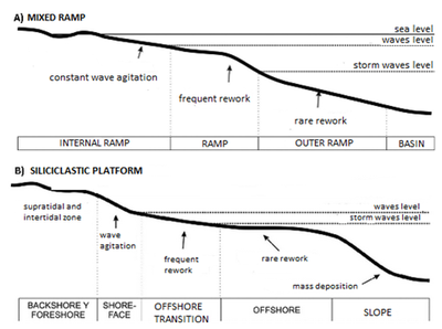
This association includes facies 1 and 2 described above, and it is interpreted as a mixed ramp environment (carbonate- siliciclastic) with significant influence of dense flows and bottom currents (Figure 3A).[15]
Facies Association B[edit]
This association includes facies 3, interpreted as a part of the mixed platform (Figure 3B).[15]
Facial variations in Vaca Muerta Formation in the margin of the Neuquén basin[edit]

The basal transgressive sequence in this sector of the basin retains the characteristics of sourcerock constant across large areas.[17]
The Lowstand System Tract (LST) is not present, the Transgressive System Tract (TST) is very small and corresponds to the regional flood event. The section is dominated by high sea deposits prograding (Highstand System Tracts) where three subsequences are individualized: A, B and C.
Basal transgressive section[edit]
The registration of transgressive facies could be comprised of more than one event or sequence of third order. The thickness distribution of the TST is relatively homogeneous in this sector of the basin and have little lateral variability. It has thicknesses which are close to 50 meters over 30 kilometers and gradually decreases to zero near the Medianera and TresNidos.area.
The relationship onlap on Tordillo Formation is observed over long distances as a result of the gentle slope of the substrate, recognizing princpalmente in the West to the side of Santiagueñohemigraben.
The very gradual decline in the power of this section of the Vaca Muerta Formation is affected eastward by increased thickness of about 15 meters, which is linked to the preservation of the precuyanodepocentre east of a high Trend in the area of Loma Chica and Punta Rosada, generated by tectonic inversion possible pre-Jurassic Cycle (Arregui et al. 2005).
Progradating upper section[edit]
Thickness variability in peliticfacies is marked and corresponds to the distal progradating depositional sequences comprising the high sea cycle portions.[18][19][20]
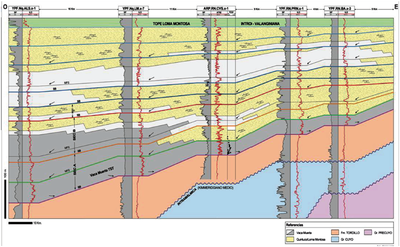
As shown in Figure 4 facial change area of Vaca Muerta shale in the prograde complex is located inmediately to the west. From east to west the high sea sequence comprises proximal or platformfacies in the entire registry. In the location of CVS.x-1 (see Figure 4) a spur is accompanied by a break in paleoestructuralslope where the structural nose would be limited by faults with subtle shift.
References[edit]
- ↑ Aguirre-Urreta, B., and E. O. Cristallini, 2009, La Cuenca Neuquina: Una perspectiva integrada: Revista de la Asociación Geológica Argentina, v. 65, no. 2
- ↑ Bodenbender, G., 1892, Sobre el terreno Jurásico y Cretácico de los Andes Argentinos, entre el Río Diamante y el Río Limay: Academia Nacional de Ciencias, v. 13, pp. 5-44.
- ↑ 3.0 3.1 Leanza, H. A., F. Sattler, R. Martinez, and O. Carbone, 2011, La Formación Vaca Muerta y Equivalentes (Jurásico Tardío – Cretácico Temprano) en la Cuenca. Neuquina, in' H. A. Leanza, C. Arregui, O. Carbone, J. C. Daniela, and J. M. Vallés, eds., Geología y Recursos Naturales de la Provincia del Neuquén, Neuquén, p. 113–129.
- ↑ Weaver, C., 1931, Paleontology of the Jurassic and Cretaceous of West Central Argentina: Memoir University of Washington 1, 469 p.
- ↑ Leanza, H. A., H. G. Marchese, and J. C. Riggi, 1977, Estratigrafía del Grupo Mendoza con especial referencia a la Formación Vaca Muerta entre los Paralelos 35º y 40º l.s. Cuenca Neuquina-Mendocina: Revista de la Asociación Geológica Argentina, v. 32, p. 190–208.
- ↑ Kietzmann, D. A., R. M. Palma, A. C. Riccardi, J. M. Chivelet, and J. López-Gómez, 2014, Sedimentology and sequence stratigraphy of a Tithonian–Valanginian carbonate ramp (Vaca Muerta Formation): A misunderstood exceptional source rock in the Southern Mendoza area of the Neuquén Basin, Argentina: Sedimentary Geology, v. 302, p. 64-86.
- ↑ 7.0 7.1 Spalletti, L. A., and G. D. Veiga, 2007, Variability of continental depositional systems during lowstand sedimentation: an example from the Kimmeridgian of the Neuquen Basin, Argentina: Latin American Journal of Sedimentology and Basin Analysis, v. 14, no. 2, p. 85-104
- ↑ 8.0 8.1 8.2 Veiga, G. D., L. A. Saplletti, J. A. Howell, and E. Schwarz, 2005, The Neuquén Basin, Argentina: A case study in sequence stratigraphy and basin dynamics: Geological Society (London) Special Publication 252
- ↑ Manceda, R., & D. Figueroa, 1995, Inversion of the Mesozoic Neuquén rift in the Malargue fold and thrust belt, Mendoza, Argentina, in: A. J. Tankard, S. R. Suarez, & H. J. Welsink (eds), Petroleum Basins of South America, AAPG Memoir 62, pp. 369-382.
- ↑ 10.0 10.1 Vergani, G. D., A. J. Tankard, H. J. Belotti, & H. J. Welsink, 1995, Tectonic evolution and paleogeography of the Neuquén Basin, Argentina, in: A. J. Tankard, R. Suárez Soruco & H. J. Welsink (eds), Petroleum Basins of South America, AAPG Memoir 62, pp. 383-402.
- ↑ Franzese, J. R., & L. A. Spalletti, 2001, Late Triassic –early Jurassic continental extension in southwestern Gondwana: tectonic segmentation and pre-break up rifting: Journal of South American Earth Sciences, vol. 4, pp. 257-270.
- ↑ Introcaso, A., M. C. Pacino, & H. Fraga, 1992. Gravity, isostasy and Andean crustal shortening between latitudes 30° and 35°S: Tectonophysics, 205, pp. 31-48.
- ↑ Ramos, V.A., 1999, Evolución Tectónica de la Argentina, in: R. Caminos (ed.) Geología Argentina. Instituto de Geología y Recursos Minerales, Anales, 29, 715-759.
- ↑ 14.0 14.1 Galeazzi, S., F. Pose, & A. Gangui, 2014, Estratigrafía Secuencial del intervalo Quintuco- Vaca Muerta en el Engolfamiento Neuquino, Cuenca Neuquina, Argentina: IX Congreso de Exploracion y Desarrollo de Hidrocarburos, Rompiendo Paraigmas, IAPG.
- ↑ 15.0 15.1 15.2 15.3 15.4 15.5 15.6 Tomassini F., D. Kietzman M. Fatín, L. Crousse, & H. Reijenstein, 2014, Estratigrafía y Análisis de facies de La Formación Vaca Muerta en el área El Trapial, Cuenca Neuquina, Argentina. Simposio de Recursos No Convencionales: ampliando el horizonte energético, pp. 591-599.
- ↑ Borbolla M. C., C. Cruz, J. Villar, N. Annizzotto, P. Benites, D. Cattaneo, 2014, Formación Vaca Muerta: variación lateral de facies y su implicancia en los cambios de espesor hacia el borde de cuenca. Perspectivas exploratorias en shale oil e la plataforma de Catriel, Cuenca Neuquina,Argentina. Simposio de Recursos No Convencionales: ampliando el horizonte energético, pp. 321-329
- ↑ Veiga, R. D., & I. A. Orchuela, 1989, Identificación de niveles generadores de hidrocarburos a partir de técnicas de perfilaje en la formación Vaca Muerta. I Congreso Nacional de Exploración de Hidrocarburos, p. 1061-1093. Mar del Plata, Argentina.
- ↑ Mitchum, R. M., and M. A. Uliana, 1985, Seismic stratigraphy of carbonate depositional sequences, Upper Jurassic-Lower Cretaceous, Neuquén Basin, Argentina, in O. R. Berg and D. G. Woolverton, eds., Seismic Stratigraphy II: An integrated approach to hydrocarbon exploration: AAPG Memoir 39, p. 255-274.
- ↑ Carozzi, A. V., I. A. Orchuela, and M. L. Rodriguez Schelotto, 1993, Depositional models of the Lower Cretaceous Quintuco–Loma Montosa Formation, Neuquén Basin, Argentina: Journal of Petroleum Geology, v. 16, 421–450.
- ↑ Charrier, R., 1985, Estratigrafía, evolución tectónica y significado de las discordancias de los Andes chilenos entre 32°S y 36°S durante el Mesozoico y Cenozoico, in J. Frutos, R. Oyarzún, and M. Pincheira, eds., Geología y Recursos Minerales de Chile: Concepción, Universidad de Concepción, pp. 101–133.
Other sources[edit]
- Aguirre-Urreta, B., & E. O. Cristallini, 2009, La Cuenca Neuquina: una perspectiva integrada: Rev. Asoc. Geol. Argent, vol. 65, n.2 , pp. 239-240, ISSN 1851-8249.
- Legarreta, L., H. J. Villar, G. A. Laffitte, C. E. Cruz & G. Vergani, 2005, Cuenca Neuquina. VI Congreso de Exploración y Desarrollo de Hidrocarburos, in G. A. Chebli, J. S. Cortiñas, L. A. Spalletti, L. Legarreta & E. L. Vallejo (eds.), Frontera Exploratoria de la Argentina, p. 233-250. Mar del Plata, Argentina.
- Legarreta, L., H. J. Villar, C. E. Cruz, G. A. Laffitte & R. Varadé, 2008, Revisión integrada de los sistemas generadores, estilos de migración-entrampamiento y volumetría de hidrocarburos en los distritos productivos de la Cuenca Neuquina, Argentina. VII Congreso de Exploración y Desarrollo de Hidrocarburos, in C. E. Cruz, J. F. Rodriguez, J. J. Hechem & H. J. Villar (eds.), Sistemas Petroleros de las Cuencas Andinas, p. 79-108, Mar del Plata, Argentina.
- Villar, H. J., C. Barcat, S. Talukdar & W. Dow, 1993, Facies generadoras de hidrocarburos, correlación petróleoroca madre y sistema petrolero en el área sudoriental del Engolfamiento Neuquino. XII Congreso Geológico Argentino y II Congreso de Exploración y Desarrollo de Hidrocarburos, Actas I, p. 382-394. Mendoza, Argentina.
- Villar, H. J., L. Legarreta, C. E. Cruz, G. A. Laffitte & G. Vergani, 2005, Los cinco sistemas petroleros coexistentes en el sector sudeste de la Cuenca Neuquina: Definición geoquímica y comparación a lo largo de una transecta de 150km. VI Congreso de Exploración y Desarrollo de Hidrocarburos, Actas en CD. Mar del Plata, Argentina.

