Difference between revisions of "Petroleum system concept: examples of application"
FWhitehurst (talk | contribs) |
Cwhitehurst (talk | contribs) |
||
| Line 18: | Line 18: | ||
==Local example== | ==Local example== | ||
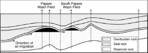
| − | [[file:petroleum-systems_fig3-21.png| | + | [[file:petroleum-systems_fig3-21.png|300px|thumb|{{figure number|1}}Cross section from the Papers Wash field from the San Juan Basin, New Mexico. From Vincelette and Chittum.<ref name=Vincelette&Chittum>Vincelette, R. R., and W. E. Chittum, 1981, [http://archives.datapages.com/data/bulletns/1980-81/data/pg/0065/0012/2500/2546.htm Exploration for Oil Accumulations in Entrada Sandstone, San Juan Basin, New Mexico]: AAPG Bulletin, vol. 65, p. 2546-2570.</ref>]] |
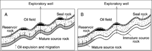
[[file:petroleum-systems_fig3-22.png|thumb|{{figure number|2}}(A) If mature source rock was located directly under the reservoir, then all traps would be filled an equal amount. (B) If the source was mature downdip to the north, then drill the deepest prospect, not the middle or shallowest prospect to the south. © Barker.<ref name=Barker1992>Barker, C., 1992, The role of source rock studies in petroleum exploration, in K. S. Johnson and B. J. Cardott, eds., Source Rocks in the Southern MidContinent, 1990 Symposium: Oklahoma Geological Survey Circular 93, p. 3-20</ref> Courtesy Oklahoma Geological Society.]] | [[file:petroleum-systems_fig3-22.png|thumb|{{figure number|2}}(A) If mature source rock was located directly under the reservoir, then all traps would be filled an equal amount. (B) If the source was mature downdip to the north, then drill the deepest prospect, not the middle or shallowest prospect to the south. © Barker.<ref name=Barker1992>Barker, C., 1992, The role of source rock studies in petroleum exploration, in K. S. Johnson and B. J. Cardott, eds., Source Rocks in the Southern MidContinent, 1990 Symposium: Oklahoma Geological Survey Circular 93, p. 3-20</ref> Courtesy Oklahoma Geological Society.]] | ||
Revision as of 18:52, 13 May 2014
| Exploring for Oil and Gas Traps | |

| |
| Series | Treatise in Petroleum Geology |
|---|---|
| Part | Traps, trap types, and the petroleum system |
| Chapter | Petroleum systems |
| Author | Leslie B. Magoon, Edward A. Beaumont |
| Link | Web page |
| Store | AAPG Store |
Linking the elements (source, reservoir, seal, and overburden) to the processes of petroleum geology (trap formation and hydrocarbon generation-migration-accumulation) is an effective exploration approach. Mapping and studying a petroleum system helps explorationists predict which traps will contain petroleum and which will not. It also helps them focus on that part of a province that will most likely contain accumulations. Below are some examples of how the petroleum system concept can be applied to petroleum exploration at local and regional levels.
Local example


Consider Figure 1, a cross section from the Papers Wash field from the San Juan Basin, New Mexico. The cross section shows that three separate prospects (traps) were tested (drilled). The deepest trap was filled to the spill point with oil, the middle trap was partially filled, and the shallowest trap was empty. This arrangement suggests that oil migrated to the traps from a mature source rock downdip to the north by filling the traps in sequence.
If these three prospects had not been tested, which would we drill first? With an understanding of the petroleum system that charged these prospects, we could be more confident in recommending which prospect to drill first. If we knew that mature source rock was located directly under the reservoir, then we would expect all traps to be filled an equal amount (Figure 2A). Conversely, if we knew that the source was mature downdip to the north, then we would drill the deepest prospect, not the middle or shallowest prospect to the south (Figure 2B).
Regional-scale applications
Petroleum system studies may serve as analogs for undocumented petroleum systems in prospective petroleum provinces. Because a petroleum system study describes both elements and processes, we can use them as look-alike and work-alike analogs. Petroleum systems also can be classified in different ways according to our needs—an example of applying a petroleum system classification scheme to petroleum exploration.
Vertically drained petroleum systems

Demaison and Huizinga:[3] divide petroleum systems into vertically and laterally drained. The Mandal-Ekofisk(!) petroleum system is a vertically drained system. Vertically drained systems are generally found in rifts, deltas, wrenches, and overthrust provinces where migration is controlled by faults and fractures. Faults and fractures limit the size of the fetch area available to traps, so a number of small- and medium-sized accumulations abound.
Vertically drained systems have the following characteristics[3]
- Accumulations occur above or near to the pod of active source rock.
- Lateral migration distances are short.
- Multiple, stacked accumulations usually contain the same genetic oil.
- Surface seepages are common in supercharged systems.
- The largest accumulations are seldom found early in the drilling history; instead, many medium to small accumulations are found.
Laterally drained petroleum systems

According to Demaison and Huizinga,[3] laterally drained petroleum systems have a laterally continuous seal overlying a laterally continuous reservoir. This reservoir/seal couplet is generally contained within a long, uninterrupted ramp. Provinces with these systems have low to moderate structural deformation. Tectonic stability is critical for maintaining seal integrity. Laterally drained systems are most commonly found in fore-deep and cratonic sag basins. Plunging low-amplitude arches are necessary for connecting traps to the pod of active source rock. The Ellesmerian(!) petroleum system is an example of a laterally drained system.
Laterally drained systems have the following characteristics:
- Oil accumulations generally occur in thermally immature strata located far from the pod of active source rock.
- Accumulations containing oil that migrated long distances on average account for 50% of the entrapped oil.
- A single reservoir of the same age as the active source rock contains most of the entrapped oil and gas.
- In supercharged systems, large deposits of heavy oil often occur in thermally immature strata near the eroded margin (geographic extent) of the petroleum system.
- The largest accumulation is usually found early in the drilling history of the system. After that, mostly small accumulations are found (J. Armentrout, personal communication, 1997).
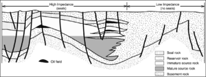
Figure 4 is an example of a laterally drained petroleum system, patterned after the Eastern Venezuelan Basin.
See also
References
- ↑ Vincelette, R. R., and W. E. Chittum, 1981, Exploration for Oil Accumulations in Entrada Sandstone, San Juan Basin, New Mexico: AAPG Bulletin, vol. 65, p. 2546-2570.
- ↑ Barker, C., 1992, The role of source rock studies in petroleum exploration, in K. S. Johnson and B. J. Cardott, eds., Source Rocks in the Southern MidContinent, 1990 Symposium: Oklahoma Geological Survey Circular 93, p. 3-20
- ↑ 3.0 3.1 3.2 3.3 3.4 Demaison, G., Huizinga, B., J., 1994, Genetic classification of petroleum systems using three factors: charge, migration, and entrapment, in L. B. Magoon and W. G. Dow, eds., The Petroleum System—From Source to Trap: AAPG Memoir 60, p. 73–89.