Difference between revisions of "Prudhoe Bay field"
(Created page with "{{publication | image = Methods14Cover.png | width = 120px | series = Methods in Exploration No. 14 | title = Horizontal Wells: Focus on the Reservoir | part =...") |
|||
| Line 23: | Line 23: | ||
==Geologic overview== | ==Geologic overview== | ||
| − | Several publications relate the exploration process leading to the discovery of Prudhoe Bay field and its geologic characteristics (Morgridge and Smith,<ref name=Morgridgeandsmith_1972>Morgridge, D. L., and W. B. Smith Jr., 1972, [http://archives.datapages.com/data/specpubs/fieldst4/data/a010/a010/0001/0450/0489.htm Geology and discovery of Prudhoe Bay Field, eastern Arctic Slope, Alaska], ''in'' R. E. King, ed., Stratigraphic oil and gas field: AAPG Memoir 16, p. 489-501.</ref> Jones and Speers,<ref name=Jonesandspeers_1976>Jones,</ref> Jamison et al.<ref name=Jamisonetal_1980>Jamison,</ref>). Briefly, Prudhoe Bay field lies along the crest of the Barrow Arch, an east-west-trending, Cretaceous anticline formed by the northward thrusting of the Brooks Range ([[:file:Mth14ch07f03.jpg|Figure 3]]). The southern flank of the Barrow Arch dips gently (2°), whereas the northern flank is much steeper. Sandstones and conglomerates of the Ivishak Formation record the north-to-south advancement of shallow-marine and fluvial depositional systems. At Prudhoe Bay, the Ivishak Formation is unconformably overlain by shallow-marine mudstones, limestones, and fine-grained sandstones of the Shublik and Sag River Formations. The Jurassic Kingak Shale forms the seal. | + | Several publications relate the exploration process leading to the discovery of Prudhoe Bay field and its geologic characteristics (Morgridge and Smith,<ref name=Morgridgeandsmith_1972>Morgridge, D. L., and W. B. Smith Jr., 1972, [http://archives.datapages.com/data/specpubs/fieldst4/data/a010/a010/0001/0450/0489.htm Geology and discovery of Prudhoe Bay Field, eastern Arctic Slope, Alaska], ''in'' R. E. King, ed., Stratigraphic oil and gas field: [http://archives.datapages.com/data/alt-browse/aapg-special-volumes/m16.htm AAPG Memoir 16], p. 489-501.</ref> Jones and Speers,<ref name=Jonesandspeers_1976>Jones, H. P., and R. G. Speers, 1976, [http://archives.datapages.com/data/specpubs/fieldst1/data/a011/a011/0001/0000/0023.htm Permo-Triassic reservoirs of Prudhoe Bay field, North Sloop Alaska], ''in'' Jules Braunstein, ed., North American oil and gas fields, [http://archives.datapages.com/data/alt-browse/aapg-special-volumes/m24.htm AAPG Memoir 24], p. 23-50.</ref> Jamison et al.<ref name=Jamisonetal_1980>Jamison, H. C., L. D. Brockett, and R. A. McIntosh, 1980, [http://archives.datapages.com/data/specpubs/fieldst2/data/a012/a012/0001/0250/0289.htm Prudhoe Bay—A ten year perspective], ''in'' M. T. Halbouty, ed., Giant oil and gas fields of the decade: [http://archives.datapages.com/data/alt-browse/aapg-special-volumes/m30.htm AAPG Memoir 30], p. 289-310.</ref>). Briefly, Prudhoe Bay field lies along the crest of the Barrow Arch, an east-west-trending, Cretaceous anticline formed by the northward thrusting of the Brooks Range ([[:file:Mth14ch07f03.jpg|Figure 3]]). The southern flank of the Barrow Arch dips gently (2°), whereas the northern flank is much steeper. Sandstones and conglomerates of the Ivishak Formation record the north-to-south advancement of shallow-marine and fluvial depositional systems. At Prudhoe Bay, the Ivishak Formation is unconformably overlain by shallow-marine mudstones, limestones, and fine-grained sandstones of the Shublik and Sag River Formations. The Jurassic Kingak Shale forms the seal. |
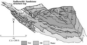
[[file:Mth14ch07f04.jpg|thumb|300px|{{figure number|4}}Generalized structure map on the top of the Sadlerochit Group. Major northwest-southeast- and west-east-trending faults and approximate fieldwide fluid distributions are shown. The white square shows the location of Drill Site 15.]] | [[file:Mth14ch07f04.jpg|thumb|300px|{{figure number|4}}Generalized structure map on the top of the Sadlerochit Group. Major northwest-southeast- and west-east-trending faults and approximate fieldwide fluid distributions are shown. The white square shows the location of Drill Site 15.]] | ||
| Line 29: | Line 29: | ||
Prudhoe Bay field is 52 km long by 19 km wide (32 mi by 12 mi). Structurally, the field occurs between 2500 and 2800 m subsea (8200 and 9200 ft), and original oil- and gas-column thicknesses were 142 m (465 ft) and 122 m (400 ft), respectively. Numerous west-to-east- and northwest-to-southeast-trending faults segregate the reservoir into isolated blocks and, in places, enhance fluid migration ([[:file:Mth14ch07f04.jpg|Figure 4]]). | Prudhoe Bay field is 52 km long by 19 km wide (32 mi by 12 mi). Structurally, the field occurs between 2500 and 2800 m subsea (8200 and 9200 ft), and original oil- and gas-column thicknesses were 142 m (465 ft) and 122 m (400 ft), respectively. Numerous west-to-east- and northwest-to-southeast-trending faults segregate the reservoir into isolated blocks and, in places, enhance fluid migration ([[:file:Mth14ch07f04.jpg|Figure 4]]). | ||
| − | Geologic investigations undertaken since field discovery are almost universal in their acceptance of a fluviodeltaic origin for the Ivishak Formation (Detterman,<ref name=Detterman_1970>Detterman,</ref> Morgridge and Smith,<ref name=Morgridgeandsmith_1972 /> Eckelmann et al.,<ref name=Eckelmannetal_1975>Eckelmann,</ref> Jones and Speers,<ref name=Jonesandspeers_1976 /> Wadman et al.,<ref name=Wadmanetal_1979>Wadman,</ref> Jamison et al.,<ref name=Jamisonetal_1980 /> Melvin and Knight,<ref name=Melvinandknight_1984>Melvin,</ref> Lawton et al.,<ref name=Lawtonetal_1987>Lawton,</ref> McMillen and Colvin,<ref name=Mcmillenandcolvin_1987>McMillen,</ref> Atkinson et al.,<ref name=Atkinsonetal_1988>Atkinson,</ref> Atkinson et al.,<ref name=Atkinsonetal_1990>Atkinson,</ref> Crowder,<ref name=Crowder_1990>Crowder,</ref> Begg et al.,<ref name=Beggetal_1992>Begg,</ref> Tye et al.<ref name=Tyeetal_1999>Tye,</ref>). Fluvial strata have been described as braided-river deposits on a coastal plain (Eckelmann et al.,<ref name=Eckelmannetal_1975 /> Jones and Speers,<ref name=Jonesandspeers_1976 /> Wadman et al.,<ref name=Wadmanetal_1979 /> Melvin and Knight,<ref name=Melvinandknight_1984 /> Lawton et al.,<ref name=Lawtonetal_1987 /> Atkinson et al.<ref name=Atkinsonetal_1990 />) or on a large alluvial fan (McGowen and Bloch,<ref name=Mcgowenandbloch_1985>McGowan,</ref> McGowen et al.<ref name=Mcgowenetal_1987>McGowan,</ref>). Petrophysically defined layers (SMUT Units; [[:file:Mth14ch07f02.jpg|Figure 2]]) constitute a gross reservoir-layering scheme for this interval, which is approximately 180 m (600 ft) thick (Wadman et al.,<ref name=Wadmanetal_1979 /> Melvin and Knight<ref name=Melvinandknight_1984 />). | + | Geologic investigations undertaken since field discovery are almost universal in their acceptance of a fluviodeltaic origin for the Ivishak Formation (Detterman,<ref name=Detterman_1970>Detterman, R. L., 1970, Sedimentary history of the Sadlerochit and Shublik Formations in northeastern Alaska, ''in'' W. L. Adkison and M. M. Brosge, eds., Proceedings of the geological seminar on the North Slope of Alaska: AAPG Pacific Section, p. o1-o13.</ref> Morgridge and Smith,<ref name=Morgridgeandsmith_1972 /> Eckelmann et al.,<ref name=Eckelmannetal_1975>Eckelmann, W. R., R. J. Dewitt, and W. L. Fisher, 1975, Prediction of fluvial-deltaic reservoir geometry, Prudhoe Bay Field, Alaska: Proceedings of the 9th World Petroleum Field, Congress: John Wiley and Sons, International, v. 2, p. 223-227.</ref> Jones and Speers,<ref name=Jonesandspeers_1976 /> Wadman et al.,<ref name=Wadmanetal_1979>Wadman, D. H., D. E. Lamptecht, and I. Mrosovsky, 1979, [https://www.onepetro.org/journal-paper/SPE-7531-PA Joint geologic/engineering analysis of the Sadlerochit Reservoir, Prudhoe Bay Field]: Journal of Petroleum Technology, v. 31, p. 933-940.</ref> Jamison et al.,<ref name=Jamisonetal_1980 /> Melvin and Knight,<ref name=Melvinandknight_1984>Melvin,</ref> Lawton et al.,<ref name=Lawtonetal_1987>Lawton,</ref> McMillen and Colvin,<ref name=Mcmillenandcolvin_1987>McMillen,</ref> Atkinson et al.,<ref name=Atkinsonetal_1988>Atkinson,</ref> Atkinson et al.,<ref name=Atkinsonetal_1990>Atkinson,</ref> Crowder,<ref name=Crowder_1990>Crowder,</ref> Begg et al.,<ref name=Beggetal_1992>Begg,</ref> Tye et al.<ref name=Tyeetal_1999>Tye,</ref>). Fluvial strata have been described as braided-river deposits on a coastal plain (Eckelmann et al.,<ref name=Eckelmannetal_1975 /> Jones and Speers,<ref name=Jonesandspeers_1976 /> Wadman et al.,<ref name=Wadmanetal_1979 /> Melvin and Knight,<ref name=Melvinandknight_1984 /> Lawton et al.,<ref name=Lawtonetal_1987 /> Atkinson et al.<ref name=Atkinsonetal_1990 />) or on a large alluvial fan (McGowen and Bloch,<ref name=Mcgowenandbloch_1985>McGowan,</ref> McGowen et al.<ref name=Mcgowenetal_1987>McGowan,</ref>). Petrophysically defined layers (SMUT Units; [[:file:Mth14ch07f02.jpg|Figure 2]]) constitute a gross reservoir-layering scheme for this interval, which is approximately 180 m (600 ft) thick (Wadman et al.,<ref name=Wadmanetal_1979 /> Melvin and Knight<ref name=Melvinandknight_1984 />). |
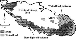
[[file:Mth14ch07f05.jpg|thumb|300px|{{figure number|5}}Map of recovery processes active in Prudhoe Bay field. Gravity drainage is the dominant recovery mechanism in the north-central part of Prudhoe, whereas the eastern, southern, and western field margins are under active waterflood and miscible-injectant recovery.]] | [[file:Mth14ch07f05.jpg|thumb|300px|{{figure number|5}}Map of recovery processes active in Prudhoe Bay field. Gravity drainage is the dominant recovery mechanism in the north-central part of Prudhoe, whereas the eastern, southern, and western field margins are under active waterflood and miscible-injectant recovery.]] | ||
Revision as of 19:54, 7 December 2015
| Horizontal Wells: Focus on the Reservoir | |
| |
| Series | Methods in Exploration No. 14 |
|---|---|
| Chapter | Results and conclusions of a horizontal-drilling program at South Pass 62 salt-dome field |
| Author | E. P. Mason, M. J. Bastian, R. Detomo, M. N. Hashem, A. J. Hildebrandt |
| Link | Web page |
| Store | AAPG Store |
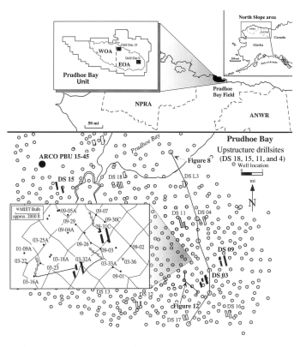
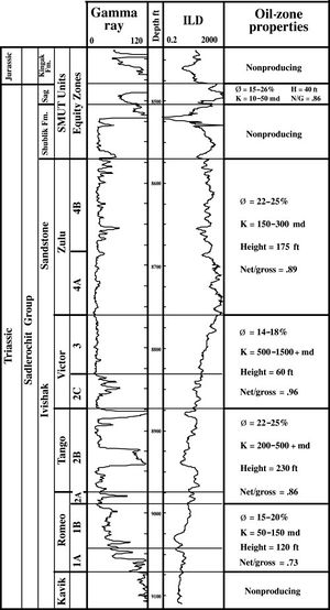
Prudhoe Bay field lies on the Alaska coastal plain between Naval Petroleum Reserve No. 4 (NPRA) and the Arctic National Wildlife Refuge (ANWR; Figure 1). Present-day production from Permian-Triassic sandstones and conglomerates of the Ivishak Formation (Figure 2) is approximately 550 MSTBD.
Geologic overview
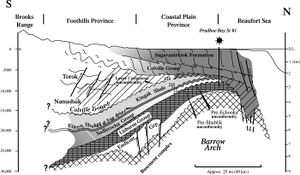
Several publications relate the exploration process leading to the discovery of Prudhoe Bay field and its geologic characteristics (Morgridge and Smith,[1] Jones and Speers,[2] Jamison et al.[3]). Briefly, Prudhoe Bay field lies along the crest of the Barrow Arch, an east-west-trending, Cretaceous anticline formed by the northward thrusting of the Brooks Range (Figure 3). The southern flank of the Barrow Arch dips gently (2°), whereas the northern flank is much steeper. Sandstones and conglomerates of the Ivishak Formation record the north-to-south advancement of shallow-marine and fluvial depositional systems. At Prudhoe Bay, the Ivishak Formation is unconformably overlain by shallow-marine mudstones, limestones, and fine-grained sandstones of the Shublik and Sag River Formations. The Jurassic Kingak Shale forms the seal.
Prudhoe Bay field is 52 km long by 19 km wide (32 mi by 12 mi). Structurally, the field occurs between 2500 and 2800 m subsea (8200 and 9200 ft), and original oil- and gas-column thicknesses were 142 m (465 ft) and 122 m (400 ft), respectively. Numerous west-to-east- and northwest-to-southeast-trending faults segregate the reservoir into isolated blocks and, in places, enhance fluid migration (Figure 4).
Geologic investigations undertaken since field discovery are almost universal in their acceptance of a fluviodeltaic origin for the Ivishak Formation (Detterman,[4] Morgridge and Smith,[1] Eckelmann et al.,[5] Jones and Speers,[2] Wadman et al.,[6] Jamison et al.,[3] Melvin and Knight,[7] Lawton et al.,[8] McMillen and Colvin,[9] Atkinson et al.,[10] Atkinson et al.,[11] Crowder,[12] Begg et al.,[13] Tye et al.[14]). Fluvial strata have been described as braided-river deposits on a coastal plain (Eckelmann et al.,[5] Jones and Speers,[2] Wadman et al.,[6] Melvin and Knight,[7] Lawton et al.,[8] Atkinson et al.[11]) or on a large alluvial fan (McGowen and Bloch,[15] McGowen et al.[16]). Petrophysically defined layers (SMUT Units; Figure 2) constitute a gross reservoir-layering scheme for this interval, which is approximately 180 m (600 ft) thick (Wadman et al.,[6] Melvin and Knight[7]).
Four reservoir-depletion mechanisms (gravity drainage/gas-cap expansion, waterflooding, miscible-gas flooding, and gas cycling) operate simultaneously at Prudhoe Bay (Figure 5; Szabo and Meyers[17]). Each process is managed to work in concert with the existing fluid distribution (expanding gas cap, injected water, and oil), regional geology (2° southward structural dip; intersecting east-west and northwest-southeast fault trends), and field-scale geology. Interbedded conglomerates, sandstones, and mudstones create a spatially variable rock volume containing permeabilities ranging from a few millidarcys to tens of darcys. Tailoring horizontal wells and their completions to suit specific engineering and geologic conditions significantly increases primary and tertiary recovery from fine-grained sandstones and conglomerates in Prudhoe Bay field.
References
- ↑ 1.0 1.1 Morgridge, D. L., and W. B. Smith Jr., 1972, Geology and discovery of Prudhoe Bay Field, eastern Arctic Slope, Alaska, in R. E. King, ed., Stratigraphic oil and gas field: AAPG Memoir 16, p. 489-501.
- ↑ 2.0 2.1 2.2 Jones, H. P., and R. G. Speers, 1976, Permo-Triassic reservoirs of Prudhoe Bay field, North Sloop Alaska, in Jules Braunstein, ed., North American oil and gas fields, AAPG Memoir 24, p. 23-50.
- ↑ 3.0 3.1 Jamison, H. C., L. D. Brockett, and R. A. McIntosh, 1980, Prudhoe Bay—A ten year perspective, in M. T. Halbouty, ed., Giant oil and gas fields of the decade: AAPG Memoir 30, p. 289-310.
- ↑ Detterman, R. L., 1970, Sedimentary history of the Sadlerochit and Shublik Formations in northeastern Alaska, in W. L. Adkison and M. M. Brosge, eds., Proceedings of the geological seminar on the North Slope of Alaska: AAPG Pacific Section, p. o1-o13.
- ↑ 5.0 5.1 Eckelmann, W. R., R. J. Dewitt, and W. L. Fisher, 1975, Prediction of fluvial-deltaic reservoir geometry, Prudhoe Bay Field, Alaska: Proceedings of the 9th World Petroleum Field, Congress: John Wiley and Sons, International, v. 2, p. 223-227.
- ↑ 6.0 6.1 6.2 Wadman, D. H., D. E. Lamptecht, and I. Mrosovsky, 1979, Joint geologic/engineering analysis of the Sadlerochit Reservoir, Prudhoe Bay Field: Journal of Petroleum Technology, v. 31, p. 933-940.
- ↑ 7.0 7.1 7.2 Melvin,
- ↑ 8.0 8.1 Lawton,
- ↑ McMillen,
- ↑ Atkinson,
- ↑ 11.0 11.1 Atkinson,
- ↑ Crowder,
- ↑ Begg,
- ↑ Tye,
- ↑ McGowan,
- ↑ McGowan,
- ↑ Szabo,
