Cuba: Geology and regional setting
| Geology of Cuba | |
| |
| Series | Studies in Geology |
|---|---|
| Author | Georges Pardo |
| Link | Web page |
| Store | AAPG Store |
_03.jpg)
The geology of Cuba has been a challenge to geologists because of features such as the presence of well-preserved Jurassic ammonites, the rich Tertiary foraminiferal faunas (including remarkable Paleogene orbitoids), the gigantic Upper Cretaceous rudistids, the spectacular limestone Mogotes of Pinar del Rio, the extensive outcrops of ultrabasic igneous rocks, the chromite and manganese deposits, and the extraordinary structural complexity. In addition to these features, the numerous petroleum seeps, many of them coming out of basic igneous rock, have attracted much attention.

Regional setting
Cuba is the largest of the Caribbean islands and has an arclike shape, concave to the south (Figure 1). This shape has tempted some authors to call Cuba an island arc. The truth is much more complex. The broad and deep Strats of Florida separate Cuba from Florida, and the narrow, and relatively shallow, Nicholas and Old Bahamas channels separate Cuba from the Bahamas. To the northwest, Cuba adjoins the Gulf of Mexico and is separated from the Yucatan Platform by the narrow but deep Yucatan Channel. To the south, the Yucatan Basin appears to be enclosed between Cuba to the north and the Cayman Ridge, which is the westward continuation of the Sierra Madre in the southern Oriente province. Cuba, the Cayman Basin, and the Cayman Ridge appear to constitute a physiographic province between the stable margin of the North American craton and the highly mobile Caribbean Basin. This province is separated from the Chortis-Nicaraguan rise block, including Jamaica and Hispaniola, by the east to west pull-apart basin of the Cayman trough, whose spreading center has been recording the eastward migration of the Caribbean plate since the late Eocene.

Over most of its length, the northern coast of Cuba is the dividing line between stable conditions (at least since the Middle Jurassic) to the north and west and very complex ones to the south. Although it is geologically deformed (Figure 2), the part of the northern coast of Cuba extending from eastern Natanzas to western Oriente belongs to the Florida-Bahamas carbonate bank province. To the south, in part under an upper Eocene or younger cover, is a relatively narrow belt, 45-160 km (28-99 mi) wide, of intensely folded and faulted Middle Jurassic to middle Eocene rocks consisting, from north to south, of:
- the north-central sedimentary terranes, characterized by very thick platform carbonates and evaporites on the north and a relatively thin section of platform to pelagic carbonates and cherts on the south
- the ophiolitic basic igneous-volcanic (called igneous-volcanic because of being a mixture of intrusive and volcanic rocks with a general predominance of volcanic rocks) terranes, with ultrabasic intrusive rocks, many types and great thicknesses of basic, basaltic to andesitic volcanic rocks, volcanic-derived sediments, and granodioritic intrusives
- the southwestern sedimentary terranes, with primarily thin stratigraphic sections of platform to pelagic carbonates and cherts but locally with great thicknesses of older, continental-derived sandstones and shales showing various degrees of metamorphism


The most striking feature about the geology of the island is the great disparity between the ophiolite-volcanic sequence of the basic igneous-volcanic terranes and the sedimentary sequences of the north-central and southwestern sedimentary terranes. Except for a few notable cases, essentially no relationship exists between these sedimentary and igneous terranes. There has been much argument about how the terranes came into contact and became structurally mixed, but it is generally accepted today that the ophiolite-volcanic sequence is totally allochthonous. Figure 3 shows a map of Cuba's major structural features and terrane distribution, and Figure 4 shows, in cross section, the structural relations between the various terranes.
Although Cuba is now part of the North American continent, it is a remnant of a Cretaceous to early Tertiary orogenic belt that has been preserved because of the local configurations of the North American and Caribbean plates. As a consequence, Cuba exposes sequences of Upper Jurassic and Cretaceous nonvolcanic pelagic sediments that are rare, if not unique, in the Caribbean as well as in North, Central, and South America. However, Cuba has facies and faunal similarities with equivalent strata of the Tethys region, specifically the Alps and Italian Apennines.
Similarities and differences exist between the Jurassic–Cretaceous sedimentary sections of Cuba and other areas in the region.
Nannoconus biomicrites containing aptychi, identical with the Neocomian of Cuba (and the Alps), are present in southern Belize, south of the Maya Mountains;[2] [3] in Mexico, in the Lower Cretaceous of the Sierra Madre Oriental; and in the coreholes of Deep Sea Drilling Project Leg 77 in the southeastern Gulf of Mexico (this type of Cretaceous sediment is widespread in the deep Atlantic Ocean).
In the Maya Block of the Yucatan Peninsula (and northern Belize, north and west of the Maya Mountains), all the reported carbonates belong to the Cretaceous Coban and Campur formations. They are similar to the bank carbonates of the Bahamas Platform and, therefore, are similar to the bank carbonates of north-central Cuba. The Coban Formation grades northward into a thick evaporite section, which overlies the dominantly red clastics of the Todos los Santos Formation, that has been compared to the San Cayetano Formation of Cuba's Pinar del Rio. Carbonates exist in the highly deformed Motagua fault zone, in central Guatemala, but similarity to carbonates found in Cuba is uncertain.
The clastic El Plan Formation in the Chortis block of Central America in Honduras has been compared to the San Cayetano Formation. It shows lithologic and paleoenvironmental similarities. However, its Triassic to Middle Jurassic age, although somewhat in doubt, makes it older than the San Cayetano. El Plan Formation is a very controversial unit because all the contacts with other units are tectonic.
Present in much of Central America is a Cretaceous carbonate section unlike the Cuban carbonates of the same age. It consists of Neocomian to Cenomanian, mostly shallow-water Yojoa Group limestone underlain by Upper Jurassic to Lower Cretaceous clastics of the Honduras Group and overlain by the Upper Cretaceous Valle de los Angeles Group that consists mostly of red beds.
Similar to the northeastern Cuban evaporites are Upper Jurassic(?) to Lower Cretaceous Maraval evaporites in the Paria Peninsula and Gulf of Paria, in the southern Caribbean between Venezuela and Trinidad. The metamorphosed clastics and marbles of the Jurassic to Lower Cretaceous Caracas series in northern Venezuela have some similarities to Cuba's southern metamorphic massifs. In addition, the thick section of Upper Jurassic clastics of the Cosina Group (overlain by fossiliferous Neocomian carbonates of the Kesima, Palare, Moina, and Yaruma formations) in the Guajira Peninsula have similarities to the San Cayetano of Cuba's Pinar del Rio. Some similarity exists between the Orbitolina-bearing reef carbonates of Cuba, Venezuela's Lower Cretaceous Cogollo Group and Cantil Formation, and contemporaneous facies of the Florida-Bahamas Platform.
Close similarities exist between the Mesozoic igneous intrusive and associated volcanic rocks of Cuba and those of the Caribbean.
Ophiolites are common throughout the Caribbean and extend from the Motagua fault zone, between the Maya and Chortis block, to Puerto Rico. They also form the floor of the Cayman Trench. These rocks are also common along the northern coast of South America from Tobago to the Guajira Peninsula, although they are not as intensely serpentinized as in the northern Caribbean. Cuba's outcrops of ultrabasic rocks are the most extensive in the region.
Similarities exist between the Caribbean and the Cuban Upper Cretaceous volcanic and associated intrusive rocks. The Cuban Upper Cretaceous granodioritic intrusion has counterparts outcropping in Hispaniola, Jamaica, and Puerto Rico in the north (where the intrusive's ages range into the early Tertiary) and in Aruba, the Venezuelan Antilles, and the Aves Ridge in the south. Volcanics containing a characteristic fauna of Acteonella, large rudists (Hippurites), and orbitoids are present in Cuba, Jamaica, Hispaniola, Puerto Rico, the Dutch West Indies, and northern Venezuela, suggesting a connection between the various parts of the volcanic province.
Other than the Yucatan Basin, Cuba is probably the only place in the Caribbean with complete sections representative of the early Caribbean region after the separation of North and South America and before the formation of the present Caribbean plate in the Tertiary.
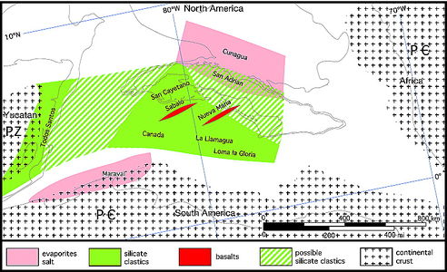
Figure 5 Cuba. 163 Ma: Callovian. PC = Precambrian; PZ = Paleozoic.[1]
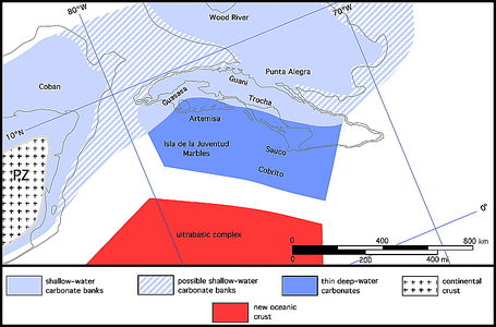
Figure 6 Cuba. 144 Ma: early Tithonian.[1]
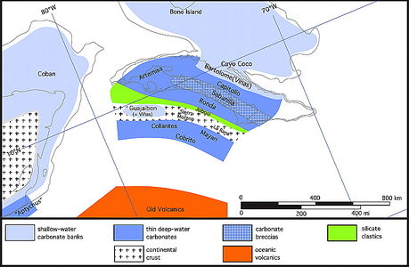
Figure 7 Cuba. 132 Ma: Valanginian.[1]
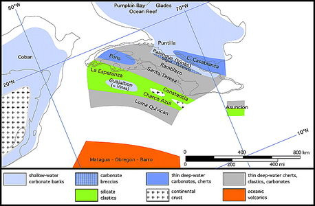
Figure 8 Cuba. 110 Ma: Aptian.[1]
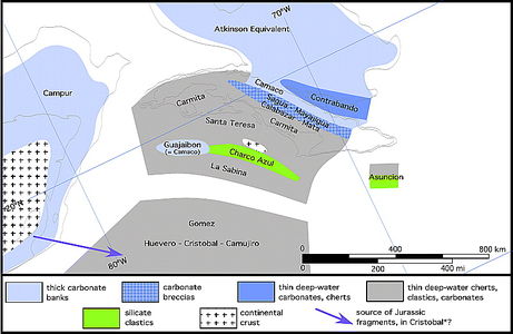
Figure 9 Cuba. 94 Ma: Cenomanian.[1]


Geologic history
The summary here of the geological history of Cuba has been strongly influenced by the geology of central Cuba. However, the timing of the events was not isochronous along the whole length of the orogen.
Paleogeographic maps (Figures 5-14) illustrate the possible past distribution of the most characteristic stratigraphic units. These maps are on a continental drift base modified from the Ocean Drilling Stratigraphic Network (ODSN) created in 2005 by the University of Bremen, with Florida occupying a fixed position. In all maps, Cuba is shown in its present position relative to Florida, although different parts of the island came from various places.
In these maps, autochthonous nappes, allochthonous nappes, and subduction will be used to describe, respectively, the thrusting toward the continent of the sediments, the basic igneous-volcanic rocks, and the subduction. Supported by observations in Cuba and elsewhere, these maps (as well as cross sections discussed later) show subduction as the main cause of the uplift of a convergent continental margin or ocean floor, whereas the nappes are the result of sedimentary or volcanic cover sliding away, under the force of gravity, from the area uplifted by subduction.
Burke,[4] Pindell and Barrett,[5] Iturralde-Vinent,[6] Cobiella-Reguera,[7] Garcia-Casco et al.,[8] Giunta et al.,[9] and Pindell et al.[10] have interpreted the Cretaceous Cuban subduction as northeast dipping and reversing polarity to the southwest during the Upper Cretaceous. Cuba's geology suggests that the subduction was continuously north dipping, and this concept is discussed in more detail below.
The paleogeographic history presented here is in general agreement with that of Pszczolkowski.[11] Differences are, for example, the position of the Guajaibon–Sierra Azul belt, the origin of the middle Cretaceous quartzose clastics, and the dip of the subduction zone.
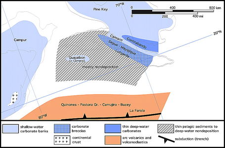
Figure 10 Cuba. 80 Ma: Santonian.[1]
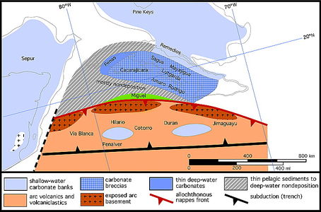
Figure 11 Cuba. 67 Ma: Maastrichtian.[1]
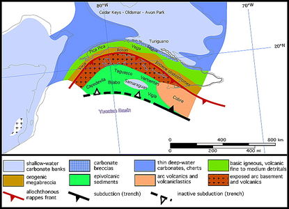
Figure 12 Cuba. 50 Ma: top lower Eocene.[1]
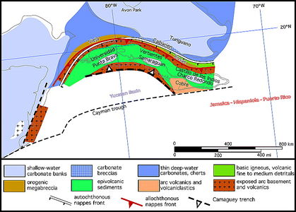
Figure 13 Cuba. 40 Ma: base upper Eocene.[1]
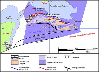
Figure 14 Cuba. Present.[1]


Early(?)-Middle Jurassic
Very little is known about the pre-Late Jurassic history of the island except that the lower part of the San Cayetano clastics might be Lower Jurassic (163 Ma; Figure 5). The San Cayetano must have been deposited over an initially rifting basement that probably included fragments of continental crust as well as basaltic flows. This is supported by the pre-Neocomian granodioritic klippen of La Rana, Tres Guanos, and Rancho Veloz and the occurrences of the El Sabalo and Nueva Maria tholeitic basalts underlying the sedimentary section of the northern Rosario belt and Cifuentes* belt of the Sierra de Camajan.
It can also be assumed that, prior to the deposition of the Upper Jurassic rocks, a large area of basement was exposed to the northwest, extending from Florida's Sarasota arch to the Maya Mountains. The nature of this basement is generally unknown, but it must have been of granitic to granodioritic composition as indicated by the arkosic nature of the San Cayetano Formation. In south Florida, several wells have penetrated an undifferentiated Jurassic–Triassic volcanic section and Paleozoic granite. The basement must also have included Paleozoic sediments known to outcrop in the Maya Mountains, present as fragments in San Cayetano conglomerates, and, perhaps, as exotics in the Cayo Coco Formation. The bulk of the San Cayetano Formation accumulated south of this basement high. The San Cayetano clastics could have originated from the Gulf of Mexico, as well as nearby South America. As already mentioned, some studies indicate that the southwestern part of the San Cayetano originated from the southwest, and the northeastern part originated from the northeast. Structural complexity makes source direction hard to evaluate.
Toward the northeast, pre-Upper Jurassic sediments have not been observed in situ, but the Cunagua salt suggests the presence of an evaporite basin correlating with the Louann Salt and Maraval evaporites and, possibly, as suggested by the San Adrian Formation, interfingering with the San Cayetano.
As rifting continued, new oceanic crust formed with outpouring of basalts (El Sabalo) and serpentinization of the upper mantle.
References
- ↑ 1.00 1.01 1.02 1.03 1.04 1.05 1.06 1.07 1.08 1.09 1.10 1.11 1.12 1.13 Pardo, Georges, 2009, The geology of Cuba: AAPG Studies in Geology 58, 73 p.
- ↑ Flores, G., 1952, Geology of northern British Honduras: AAPG Bulletin, v. 36, p. 404-413.
- ↑ Schafhauser, A., W. Stinnesbeck, B. Holland, T. Adatte, and J. Remane, 2003, Lower Cretaceous pelagic limestones in southern Belize: Proto-Caribbean deposits on the southeastern Maya block, in C. Bartolini, R. T. Buffler, and J. Blickwede, eds., The Circum-Gulf of Mexico and the Caribbean: Hydrocarbon habitats, basin formation, and plate tectonics: AAPG Memoir 79, p. 624-637.
- ↑ Burke, K., 1988, Tectonic evolution of the Caribbean: Annual Review of Earth and Planetary Sciences, v. 16, p. 201-230.
- ↑ Pindell, J. L., and S. F. Barrett, 1990, Geologicla evolution of the Caribbean region, a plate-tectonic perspective, in The geology of North America, v. H: The Caribbean region: Geological Society of America, p. 405-432.
- ↑ Iturralde-Vinent, M. A., ed., 1996, Ofiolitas y arcos volcanicos de Cuba (Cuban ophiolites and volcanic arcs), in International Union of Geological Sciences-United Nations Educational, Scientific, and Cultural Organization International Geological Correlation Programe, Contribution 1, Project 364 (Geological correlation of ophiolites and volcanic arc terrane in the Circum-Caribbean realm), 254 p.
- ↑ Cobiella-Reguera, J. L., 2005, Emplacement of Cuban ophiolites: Geologica Acta, v. 3, no. 3, p. 273-294.
- ↑ Garcia-Casco, A., R. L. Torres-Roldan, M. A. Iturralde-Vinent, G. Millan, K. Nunez Cambra, C. Lazaro, and A. Rodriguez Vega, 2006, High pressure metamorphism of ophiolites in Cuba: Geologica Acta, v. 4, no. 1-2, p. 63-88.
- ↑ Giunta, G., L. Beccaluav, and F. Siena, 2006, Caribbean plate margin evolution: constraints and current problems: Geologica Acta, v. 4, no. 102, p. 265-277.
- ↑ Pindell, J. L., L. Kennan, K. P. Stanek, W. V. Maresh, and G. Draper, 2006, Foundations of Gulf of Mexico and Caribbean evolution: Eight controversies resolved: Geologica Acta, v. 4, no. 1-2, p. 303-341.
- ↑ Pszczolkowski, A., 1999, The exposed passive margin of North America in western uba, Caribbean basins, in P. Mann, ed., Sedimentary basins of the world: Amsterdam, Elsevier Sciene B.V., v. 4, p. 93-121.