Libya hydrocarbon provinces
| Petroleum systems of the Tethyan region | |

| |
| Series | AAPG Memoir |
|---|---|
| Chapter | Hydrocarbon Provinces of Libya: A Petroleum System Study |
| Author | Hassan S. Hassan and Christopher C. G. Kendall |
| Link | Web page |
| Store | AAPG Store |
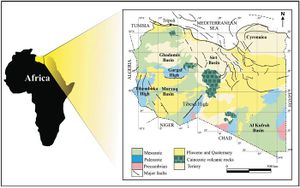
Libya produces 1.74 million barrels of oil a day. Future exploration and development will increase this amount. The producing sedimentary basins in Libya are the Sirt, Ghadamis, Murzuq, and Tripolitania Basins, collectively containing the country’s major 320 producing oil fields. The total reserves exceed 44 billion barrels of recoverable oil and 37 trillion cubic feet of gas. The Silurian and Upper Cretaceous sections, rich in type II kerogen, form the source rocks for the petroleum and gas in these basins.
The Sirt Basin, the most prolific oil basin in Africa, contains 89% of Libya’s reserves and 16 giant oil fields. Reservoir rocks range in age from Precambrian to Eocene. The Upper Cretaceous Sirt Shale is the major source rock. It represents a thick sequence that accumulated in major grabens while shallow-marine carbonates and reefs collected on adjacent horsts and platforms to form major reservoir rocks.
The Ghadamis intracratonic sag basin contains up to 5200 m (17,060.4 ft) of Paleozoic through Mesozoic clastics. The estimated recoverable reserves are more than 3 billion barrels of oil in the Upper Silurian Acacus Sandstone and Devonian Tadrart and Ouan Kasa Sandstones. The Devonian and Silurian Shales are the basin’s major source rocks; the latter is the most important.
The Murzuq Basin contains up to 4000 m (13,123.4 ft) of Cambrian to Quaternary sedimentary rocks. The estimated recoverable reserves are more than 2 billion barrels of oil, of which a significant portion is in the Memouniat Sandstone. Acacus, Tadrart, and Ouan Kasa Sandstones are very prospective reservoirs. The Tanezzuft Shale, as thick as 500 m, is the major source rock.
Major offshore oil production in the El Bouri oil field of the Tripolitania Basin is from the Eocene nummulitic limestone, producing 60,000 bbl/d with 800 million barrels of reserves. The Bou Dabbous argillaceous limestone is the principal source for the El Bouri field.
The Cyrenaica Platform and Al Kufrah Basin have had a few oil discoveries but no commercial production. However, recent subsurface data for northeastern Libya indicate the presence of a thick Cretaceous–Tertiary sedimentary section with hydrocarbon potential. Devonian sandstones and Tertiary carbonates contain natural gas.
See also[edit]
References[edit]
- ↑ Rusk, D. C., 2001, Libya: Petroleum potential of the underexplored basin centers&emdash;A twenty-first-century challenge, in M. W. Downey, J. C. Threet, and W. A. Morgan, eds., Petroleum provinces of the twenty-first century: AAPG Memoir 74, p. 429-452.
- ↑ Ramos, E., M. Marzo, J. M. de Gibert, K. Tawengi, A. Khoja, and N. D. Bolatti, 2006, Stratigraphy and sedimentology of the Middle Ordovician Haouaz Formation (Murzuq Basin, Libya): AAPG Bulletin, v. 90, no. 9, p. 1309-1336.
