Search results
Jump to navigation
Jump to search
There is a page named "Basin" on this wiki. See also the other search results found.
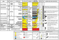
File:M114CH03FG04.jpg Summary stratigraphic compilation of the Barmer Basin in the context of petroleum systems showing the stratigraphic terminology u(700 × 473 (113 KB)) - 17:50, 4 January 2019- ...the overpressured interval of the Anadarko basin], in P. J. Ortoleva, ed., Basin Compartments and Seals: [http://store.aapg.org/detail.aspx?id=748 AAPG Memo ...tm Megacompartment complex in the Anadarko basin], in P. J. Ortoleva, ed., Basin Compartments and Seals: [http://store.aapg.org/detail.aspx?id=748 AAPG Memo3 KB (440 words) - 17:58, 17 February 2022
- | chapter = Sedimentary basin analysis ...ile:Sedimentary-basin-analysis_fig4-13.png|1]] through [[:file:Sedimentary-basin-analysis_fig4-13.png|4]].4 KB (557 words) - 19:59, 22 February 2022
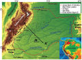
File:M114CH08FG01.jpg ...eastern forelands of the northern Andes in Colombia, the so-called Llanos Basin. The main map shows the topography, the fluvial system, the oil and gas see(659 × 486 (100 KB)) - 18:08, 7 January 2019- ...pts], ''in'' Peters, Kenneth E., David J. Curry, and Marek Kacewicz, eds., Basin modeling: New horizons in research and applications: [http://store.aapg.org1 KB (176 words) - 21:06, 6 July 2015
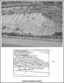
File:M91FG178.JPG ...ral accretion surfaces in the upper section of a point bar sandstone, Ebro basin, Spain. The point bar grew by accretion from left to right. From Shepherd,(800 × 1,042 (186 KB)) - 21:26, 3 August 2015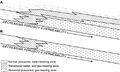
File:BasinCenteredGasFig2.jpg ...aring zones for (A) direct and (B) indirect BCGAs. From Law, Ben E., 2002, Basin-centered gas systems: AAPG Bulletin, v. 86, no. 11, p. 1891-1919.(500 × 298 (46 KB)) - 22:14, 13 January 2015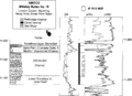
File:Evaluating-tight-gas-reservoirs fig1.png ...rrelations to eletric log responses of the Frontier Formation, Green River basin, Wyoming. Lithologies and sedimentary characteristics are summarized in thi(1,937 × 1,409 (50 KB)) - 18:47, 14 January 2014- ...pts], ''in'' Peters, Kenneth E., David J. Curry, and Marek Kacewicz, eds., Basin modeling: New horizons in research and applications: [http://store.aapg.org1 KB (203 words) - 19:52, 25 June 2015
- ...pts], ''in'' Peters, Kenneth E., David J. Curry, and Marek Kacewicz, eds., Basin modeling: New horizons in research and applications: [http://store.aapg.org1 KB (185 words) - 21:11, 6 July 2015
- ...pts], ''in'' Peters, Kenneth E., David J. Curry, and Marek Kacewicz, eds., Basin modeling: New horizons in research and applications: [http://store.aapg.org1 KB (181 words) - 21:10, 6 July 2015
- ...pts], ''in'' Peters, Kenneth E., David J. Curry, and Marek Kacewicz, eds., Basin modeling: New horizons in research and applications: [http://store.aapg.org1 KB (180 words) - 21:11, 6 July 2015
- ...s map and corresponding paleogeographic map of the Middle Miocene Taranaki basin, offshore western New Zealand. From Bally;<ref name=Bally1987>Bally, A. W., ...] and the corresponding paleogeographic map of the Middle Miocene Taranaki basin, offshore western New Zealand. The paleogeographic map depicts [[lithofacie3 KB (346 words) - 20:13, 4 February 2022
- ...of methane production from [[coal]] beds) should be designed on a basin-by-basin and state-by-state basis.1 KB (187 words) - 16:47, 18 July 2016
- ...the top and bottom seals of a regional pressure compartment in a foreland basin.]] ...artments are called '''pressure compartments'''. They are defined within a basin from pressure measurements.6 KB (811 words) - 17:58, 17 February 2022
- ...pts], ''in'' Peters, Kenneth E., David J. Curry, and Marek Kacewicz, eds., Basin modeling: New horizons in research and applications: [http://store.aapg.org1 KB (194 words) - 15:46, 8 March 2016
- | chapter = Sedimentary basin analysis ...ting [[source rock]]s. The map of hydrocarbon types in [[:file:sedimentary-basin-analysis_fig4-5.png|Figure 1]] is based on analyses of more than 2000 oil,5 KB (633 words) - 20:02, 18 February 2022
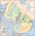
File:M114CH01FG01.jpg ...Faqira et al., 2009). MA-I and MA-II show the two areas selected for a 2-D basin modeling study. The Unayzah fields contain oil sourced by Qusaiba shales. F(685 × 692 (98 KB)) - 16:39, 28 December 2018- | chapter = Sedimentary basin analysis ...e 1]]) and [[Cross section|cross-sectional geometry]] ([[:File:Sedimentary-basin-analysis_fig4-43.png|Figure 2]]) accurately depict the trapping aspects of5 KB (715 words) - 17:07, 23 March 2022
- | chapter = Sedimentary basin analysis ...imensional, care must be taken to assemble enough cross sections to depict basin history accurately.7 KB (1,044 words) - 16:34, 22 February 2022


