File:Mth14ch07f04.jpg
Mth14ch07f04.jpg (500 × 258 pixels, file size: 39 KB, MIME type: image/jpeg)
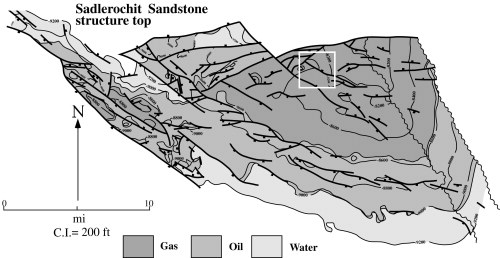
Generalized structure map on the top of the Sadlerochit Group. Major northwest-southeast- and west-east-trending faults and approximate fieldwide fluid distributions are shown. The white square shows the location of Drill Site 15. From Unique Horizontal-well Designs Boost Primary and EOR Production, Prudhoe Bay Field, Alaska , by R. S. Tye, B. A. Watson, P. L. McGuire, and M. M. Maguire, Pages 113 - 125, in AAPG Methods in Exploration No. 14: Horizontal Wells: Focus on the Reservoir, Edited by T. R. Carr, E. P. Mason, and C. T. Feazel.
File history
Click on a date/time to view the file as it appeared at that time.
| Date/Time | Thumbnail | Dimensions | User | Comment | |
|---|---|---|---|---|---|
| current | 17:58, 7 December 2015 | | 500 × 258 (39 KB) | Molyneux (talk | contribs) | Generalized structure map on the top of the Sadlerochit Group. Major northwest-southeast- and west-east-trending faults and approximate fieldwide fluid distributions are shown. The white square shows the location of Drill Site 15. From Unique Horizonta... |
You cannot overwrite this file.
File usage
The following page uses this file: