File:M106Ch07Fig06.jpg
Revision as of 21:10, 18 April 2016 by Molyneux (talk | contribs) (a) Schematic east-west structural cross section from the Jordan Valley, through the northern Highlands, Azraq Depression, Basakt Plateau, and Risha Limestone Plateau to the Iraqi border. b) Schematic north-south structural cross section from the Damasc...)

Size of this preview: 450 × 599 pixels. Other resolutions: 180 × 240 pixels | 700 × 932 pixels.
Original file (700 × 932 pixels, file size: 98 KB, MIME type: image/jpeg)
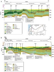
a) Schematic east-west structural cross section from the Jordan Valley, through the northern Highlands, Azraq Depression, Basakt Plateau, and Risha Limestone Plateau to the Iraqi border. b) Schematic north-south structural cross section from the Damascus Basin through the Northern Highlands and Azraq Depression to the Sirhan Depression. After NRA (2001). From Luning, S., and J. Kuss, 2014, Petroleum geology of Jordan, in L. Marlow, C. Kendall, and L. Yose, eds., Petroleum systems of the Tethyan region: AAPG Memoir 106, p. 217-239.
File history
Click on a date/time to view the file as it appeared at that time.
| Date/Time | Thumbnail | Dimensions | User | Comment | |
|---|---|---|---|---|---|
| current | 21:10, 18 April 2016 | | 700 × 932 (98 KB) | Molyneux (talk | contribs) | a) Schematic east-west structural cross section from the Jordan Valley, through the northern Highlands, Azraq Depression, Basakt Plateau, and Risha Limestone Plateau to the Iraqi border. b) Schematic north-south structural cross section from the Damasc... |
You cannot overwrite this file.
File usage
The following page uses this file: