File:M106Ch12Fig06.jpg
Revision as of 13:59, 12 May 2016 by Molyneux (talk | contribs) (nterpretation from megaseismic line 7 (reproduced from Mohammed, 2007 (see Iraq petroleum geology for reference, by permission from GeoArabia), which extends from the Arabian platform of southwestern Iraq across the Mesopotamian Foredeep to the Zag...)
No higher resolution available.
M106Ch12Fig06.jpg (690 × 337 pixels, file size: 55 KB, MIME type: image/jpeg)
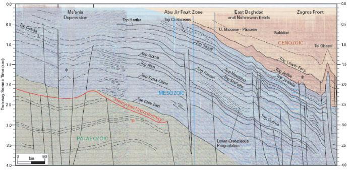
nterpretation from megaseismic line 7 (reproduced from Mohammed, 2007 (see Iraq petroleum geology for reference, by permission from GeoArabia), which extends from the Arabian platform of southwestern Iraq across the Mesopotamian Foredeep to the Zagros foldbelt in eastern Iraq. 50 km (31.1 mi). From Grabowski Jr., G. J., 2014, Iraq, in L. Marlow, C. Kendall, and L. Yose, eds., Petroleum systems of the Tethyan region: AAPG Memoir 106, p. 379-467.
File history
Click on a date/time to view the file as it appeared at that time.
| Date/Time | Thumbnail | Dimensions | User | Comment | |
|---|---|---|---|---|---|
| current | 13:59, 12 May 2016 | | 690 × 337 (55 KB) | Molyneux (talk | contribs) | nterpretation from megaseismic line 7 (reproduced from Mohammed, 2007 (see Iraq petroleum geology for reference, by permission from GeoArabia), which extends from the Arabian platform of southwestern Iraq across the Mesopotamian Foredeep to the Zag... |
You cannot overwrite this file.
File usage
The following page uses this file: