Search results
Jump to navigation
Jump to search
There is a page named "Basin" on this wiki. See also the other search results found.
Page title matches
- | title = Basin-centered gas systems ...and the generation, expulsion, migration, and accumulation of petroleum. A basin-centered gas system (BCGS) contains all of these components; however, the m4 KB (469 words) - 19:01, 14 March 2016
- #REDIRECT [[Basin outline: Gulf of Mexico example]]51 bytes (7 words) - 17:56, 15 January 2015
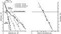
File:Sedimentary-basin-analysis fig4-54.png (1,618 × 639 (68 KB)) - 18:52, 30 January 2014
File:Sedimentary-basin-analysis fig4-35.png (1,662 × 891 (348 KB)) - 19:37, 30 January 2014
File:Sedimentary-basin-analysis fig4-14.png (780 × 463 (61 KB)) - 19:08, 30 January 2014
File:Sedimentary-basin-analysis fig4-44.png (1,454 × 1,013 (98 KB)) - 19:52, 30 January 2014
File:Sedimentary-basin-analysis fig4-22.png (730 × 571 (64 KB)) - 19:22, 30 January 2014
File:Sedimentary-basin-analysis fig4-58.png (1,594 × 875 (61 KB)) - 20:08, 30 January 2014
File:Sedimentary-basin-analysis fig4-55.png (1,660 × 1,158 (586 KB)) - 18:53, 30 January 2014
File:Sedimentary-basin-analysis fig4-40.png (1,683 × 1,114 (154 KB)) - 19:38, 30 January 2014
File:Sedimentary-basin-analysis fig4-15.png (760 × 448 (62 KB)) - 19:09, 30 January 2014
File:Sedimentary-basin-analysis fig4-45.png (1,995 × 1,163 (98 KB)) - 19:53, 30 January 2014
File:Sedimentary-basin-analysis fig4-24.png (2,355 × 1,477 (691 KB)) - 19:23, 30 January 2014
File:Sedimentary-basin-analysis fig4-59.png (1,508 × 1,093 (97 KB)) - 20:10, 30 January 2014
File:Sedimentary-basin-analysis fig4-37.png (1,530 × 1,064 (169 KB)) - 19:41, 30 January 2014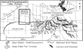
File:Sedimentary-basin-analysis fig4-16.png (701 × 412 (57 KB)) - 19:10, 30 January 2014
File:Sedimentary-basin-analysis fig4-47.png (1,427 × 1,871 (630 KB)) - 19:56, 30 January 2014
File:Sedimentary-basin-analysis fig4-23.png (1,371 × 1,646 (394 KB)) - 19:24, 30 January 2014
File:Sedimentary-basin-analysis fig4-60.png (1,656 × 1,003 (161 KB)) - 20:11, 30 January 2014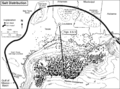
File:Sedimentary-basin-analysis fig4-7.png (1,274 × 950 (178 KB)) - 18:54, 30 January 2014


Page text matches
File:H4CH12FG5.JPG ...sley, ''in'' Peters, Kenneth E., David J. Curry, and Marek Kacewicz, eds., Basin modeling: New horizons in research and applications: AAPG Hedberg Series no(600 × 707 (97 KB)) - 20:26, 9 July 2015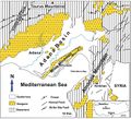
File:M106Ch13Fig11.jpg (700 × 637 (109 KB)) - 20:03, 5 July 2016- [[Category:Gulf of Mexico basin]]13 members (0 subcategories, 0 files) - 20:31, 30 January 2014
- #REDIRECT [[Plate tectonics and basin formation]]49 bytes (6 words) - 18:57, 27 July 2015
File:GiacomoneEtAlFigure2.jpg Geological regions of the Neuquén Basin.(586 × 724 (184 KB)) - 19:50, 29 October 2021- #REDIRECT [[Basin outline: Gulf of Mexico example]]51 bytes (7 words) - 17:56, 15 January 2015
- #REDIRECT [[Basin outline: Gulf of Mexico example]]51 bytes (7 words) - 14:57, 19 December 2014
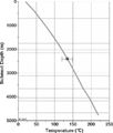
File:BasinCenteredGasFig8.jpg ...3. Pressure gradient interpreted by C. W. Spencer. From Law, Ben E., 2002, Basin-centered gas systems: AAPG Bulletin, v. 86, no. 11, p. 1891-1919.(700 × 389 (41 KB)) - 19:13, 14 January 2015
File:H4CH12FG10.JPG ...sley, ''in'' Peters, Kenneth E., David J. Curry, and Marek Kacewicz, eds., Basin modeling: New horizons in research and applications: AAPG Hedberg Series no(600 × 439 (52 KB)) - 21:21, 13 July 2015- #REDIRECT [[Province, basin, system, play, and prospect]]57 bytes (7 words) - 21:42, 6 May 2014
File:MainPageBlackWarriorBasin.jpg Black Warrior basin(400 × 400 (82 KB)) - 15:36, 22 June 2015- #REDIRECT [[Oil correlation case history: West Siberian basin]]63 bytes (8 words) - 18:55, 29 January 2014

File:GiacomoneEtAlFigure5.jpg Tectonostratigraphic phases in the Gulf of Mexico Basin.(940 × 1,164 (265 KB)) - 19:59, 29 October 2021- #REDIRECT [[Oil correlation case history: Zala basin, Hungary]]63 bytes (8 words) - 18:50, 29 January 2014
File:Evaluating-source-rocks fig6-15.png {{copyright|results of Genex 1-D basin modeling software, courtesy Institute Français du Petrole}} . Copyright: results of Genex 1-D basin modeling software, courtesy Institute Français du Petrole.(1,715 × 799 (298 KB)) - 13:54, 24 January 2014
File:Evaluating-source-rocks fig6-17.png {{copyright|results of Genex 1-D basin modeling software, courtesy Institute Français du Petrole}} . Copyright: results of Genex 1-D basin modeling software, courtesy Institute Français du Petrole.(1,704 × 858 (181 KB)) - 13:56, 24 January 2014
File:Evaluating-source-rocks fig6-18.png {{copyright|results of Genex 1-D basin modeling software, courtesy Institute Français du Petrole}} . Copyright: results of Genex 1-D basin modeling software, courtesy Institute Français du Petrole.(1,684 × 773 (111 KB)) - 13:58, 24 January 2014
File:Evaluating-source-rocks fig6-19.png {{copyright|results of Genex 1-D basin modeling software, courtesy Institute Français du Petrole}} . Copyright: results of Genex 1-D basin modeling software, courtesy Institute Français du Petrole.(1,604 × 781 (289 KB)) - 13:59, 24 January 2014
File:M114CH10FG02.jpg ...the spillpoint depth). GWC = gas–water contact. Modified from [[Hammerfest basin|Hermanrud et al.]] (2014). From AAPG Memoir 114: Petroleum Systems Analysis(641 × 652 (54 KB)) - 23:02, 8 January 2019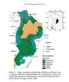
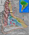
File:Parana 1.jpg Geological Map of the Paraná Basin. Milani E. J. 2004.(610 × 728 (86 KB)) - 17:38, 24 June 2015


