Difference between revisions of "Basement fault blocks and fault block patterns"
FWhitehurst (talk | contribs) |
Cwhitehurst (talk | contribs) m (added Category:Treatise Handbook 3 using HotCat) |
||
| (4 intermediate revisions by 2 users not shown) | |||
| Line 6: | Line 6: | ||
| part = Predicting the occurrence of oil and gas traps | | part = Predicting the occurrence of oil and gas traps | ||
| chapter = Using magnetics in petroleum exploration | | chapter = Using magnetics in petroleum exploration | ||
| − | | frompg = 14- | + | | frompg = 14-9 |
| − | | topg = 14- | + | | topg = 14-10 |
| author = Edward A. Beaumont, S. Parker Gay | | author = Edward A. Beaumont, S. Parker Gay | ||
| link = http://archives.datapages.com/data/specpubs/beaumont/ch14/ch14.htm | | link = http://archives.datapages.com/data/specpubs/beaumont/ch14/ch14.htm | ||
| Line 14: | Line 14: | ||
| isbn = 0-89181-602-X | | isbn = 0-89181-602-X | ||
}} | }} | ||
| − | The basement fault block pattern in sedimentary basins was formed in multiple tectonic and metamorphic episodes during the Archean and Proterozoic Eons. Basement tends to control most of the local structure and much of the stratigraphy within the overlying, younger sedimentary section. It is along the shear zones, or block boundaries of the basement, that we generally find the faults or other structures in the overlying sedimentary section. These zones of weakness are periodically reactivated by tectonic stresses or gravitational loading. Consequently, they have influenced depositional patterns and locations of structures throughout geologic time. | + | The [[basement]] fault block pattern in sedimentary basins was formed in multiple tectonic and metamorphic episodes during the Archean and Proterozoic Eons. Basement tends to control most of the local structure and much of the stratigraphy within the overlying, younger sedimentary section. It is along the shear zones, or block boundaries of the basement, that we generally find the faults or other structures in the overlying sedimentary section. These zones of weakness are periodically reactivated by tectonic stresses or gravitational loading. Consequently, they have influenced depositional patterns and locations of structures throughout geologic time. |
==Study of shield areas== | ==Study of shield areas== | ||
| Line 22: | Line 22: | ||
</gallery> | </gallery> | ||
| − | The Landsat and side-looking airborne radar(SLAR) images of exposed Precambrian crystalline crust ([[:file:using-magnetics-in-petroleum-exploration_fig14-4.png|Figure 1]]) show highly lineated terrains and demonstrate that the | + | The Landsat and side-looking airborne radar(SLAR) images of exposed Precambrian crystalline [[crust]] ([[:file:using-magnetics-in-petroleum-exploration_fig14-4.png|Figure 1]]) show highly lineated terrains and demonstrate that the lineations fall into multiple parallel or subparallel sets of varying [[strike]] directions. These overlapping [[fracture]] sets cut the basement into blocks of varying shapes and sizes. This collection of basement blocks is the '''basement fault block pattern'''. |
==Precambrian surface topography== | ==Precambrian surface topography== | ||
| − | The intensity of fracturing and mylonitization of the rocks in shear zones explains why these zones generally erode | + | The intensity of fracturing and [http://encyclopedia2.thefreedictionary.com/mylonitization mylonitization] of the rocks in shear zones explains why these zones generally erode preferentially and why they tend to control the topography of the Precambrian surface. This surface, in turn, controls much of the structure in the lower part of the sedimentary section through gravitational compaction of the sedimentary rocks. |
==Canadian Shield example== | ==Canadian Shield example== | ||
| Line 52: | Line 52: | ||
[[Category:Predicting the occurrence of oil and gas traps]] | [[Category:Predicting the occurrence of oil and gas traps]] | ||
[[Category:Using magnetics in petroleum exploration]] | [[Category:Using magnetics in petroleum exploration]] | ||
| + | [[Category:Treatise Handbook 3]] | ||
Latest revision as of 19:55, 27 January 2022
| Exploring for Oil and Gas Traps | |

| |
| Series | Treatise in Petroleum Geology |
|---|---|
| Part | Predicting the occurrence of oil and gas traps |
| Chapter | Using magnetics in petroleum exploration |
| Author | Edward A. Beaumont, S. Parker Gay |
| Link | Web page |
| Store | AAPG Store |
The basement fault block pattern in sedimentary basins was formed in multiple tectonic and metamorphic episodes during the Archean and Proterozoic Eons. Basement tends to control most of the local structure and much of the stratigraphy within the overlying, younger sedimentary section. It is along the shear zones, or block boundaries of the basement, that we generally find the faults or other structures in the overlying sedimentary section. These zones of weakness are periodically reactivated by tectonic stresses or gravitational loading. Consequently, they have influenced depositional patterns and locations of structures throughout geologic time.
Study of shield areas
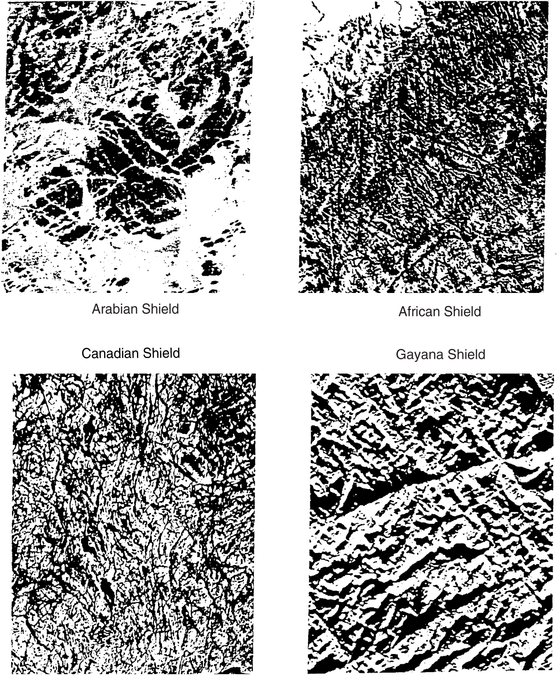
Figure 1 Landsat and SLAR images of exposed Precambrian crystalline crust. Copyright: Gay;[1] courtesy International Basement Tectonics Assoc.
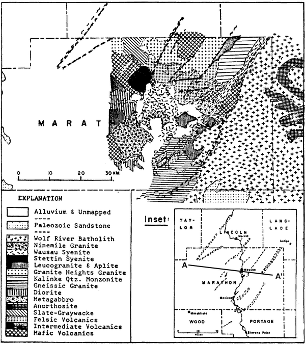
Figure 2 Geologic map of an area of crystalline basement in central Wisconsin on the southern edge of the Canadian Shield. Copyright: LaBerge;[2] courtesy International Basement Tectonics Assoc.


The Landsat and side-looking airborne radar(SLAR) images of exposed Precambrian crystalline crust (Figure 1) show highly lineated terrains and demonstrate that the lineations fall into multiple parallel or subparallel sets of varying strike directions. These overlapping fracture sets cut the basement into blocks of varying shapes and sizes. This collection of basement blocks is the basement fault block pattern.
Precambrian surface topography
The intensity of fracturing and mylonitization of the rocks in shear zones explains why these zones generally erode preferentially and why they tend to control the topography of the Precambrian surface. This surface, in turn, controls much of the structure in the lower part of the sedimentary section through gravitational compaction of the sedimentary rocks.
Canadian Shield example
Figure 2 is a geologic map of an area of crystalline basement in central Wisconsin on the southern edge of the Canadian Shield. Here, outcrops and rock exposures in shallow excavations, roadcuts, etc., abound. It is possible to map the basement geology in considerable detail. Five things stand out:
- A series of parallel to subparallel shear zones has been mapped.
- There is obvious periodicity to the shear zones, the spacing between them varying from about 4–8 km (2.5–5 mi).
- There are rock type changes across these zones.
- The width of the shear zones varies from about length::1 km (LaBerge, personal communication) up to length::2.5 km or more.
- The shear zones and geology truncate abruptly and change style across line A–A′.
See also
- Magnetic field: local variations
- Magnetics: interpreting residual maps
- Magnetics: petroleum exploration applications
References
- ↑ Gay, S.P., Jr., 1995, The basement fault block pattern: its importance in petroleum exploration, and its delineation with residual aeromagnetic techniques, in R.W. Ojakangas, ed., Proceedings of the 10th International Basement Tectonics Conference, p. 159–207.
- ↑ LaBerge, G.L., 1976, Major structural lineaments in the Precambrian of central Wisconsin: Proceedings of the First International Conference on the New Basement Tectonics, Utah Geological Assoc., p. 508–518.
External links
| find literature about Basement fault blocks and fault block patterns |