File:Cross-borehole-tomography-in-development-geology fig1.png
Revision as of 00:48, 14 January 2014 by Importer (talk | contribs) (Schematic illustration of tomographic data acquisition. Category:Geophysical methods)

Size of this preview: 800 × 536 pixels. Other resolutions: 320 × 214 pixels | 2,025 × 1,357 pixels.
Original file (2,025 × 1,357 pixels, file size: 1.66 MB, MIME type: image/png)
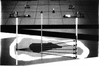
Schematic illustration of tomographic data acquisition.
File history
Click on a date/time to view the file as it appeared at that time.
| Date/Time | Thumbnail | Dimensions | User | Comment | |
|---|---|---|---|---|---|
| current | 00:48, 14 January 2014 | | 2,025 × 1,357 (1.66 MB) | Importer (talk | contribs) | Schematic illustration of tomographic data acquisition. Category:Geophysical methods |
You cannot overwrite this file.
File usage
The following page uses this file: