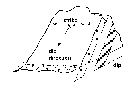
How to plot the strike data to the Rosette diagram
Definition
The orientation of a rock bed, fault, fracture, cuestas, igneous dikes, and sills can be described using strike and dip of the rock. Strike is direction of the line formed by the intersection of a fault, bed, or other planar feature and a horizontal plane. Strike indicates the attitude or position of linear structural features such as faults, beds, joints, and folds. Dip is the angle at which a planar feature is inclined to the horizontal plane; it is measured in a vertical plane perpendicular to the strike of the feature.[1]

Brunton Compass
Usually the direction of strike and dip can be determined easily with left hand rule. They also can be measured accurately with Brunton Compass. Parts of Brunton Compass explained by Figure 2:
Brunton Compass can be used for: • Measure strike and dip of planes • Measure trend and plunge of lines • Measure vertical angles • Measure bearings • Set local declination[3] In determine the direction of strike and dip, there are four quadrants at Brunton Compass such as North East, North West, South East, and South West. Each of them have value 0-90 degree. For example in Figure 3, N40o W mean the direction of strike is 40o from North to West. 45o is amount of dip. The direction of dip always perpendicular with direction of strike, so we know the direction of dip is N50o E.
How to Measure Strike