Iraq petroleum geology
There are more than 100 oil and gas fields in Iraq, containing more than 137 billion barrels of recoverable oil and more than 106 TCF of recoverable gas. Of this large resource, about 25 billion barrels of oil and 11 TCF of gas have been produced as of 2014.
Introduction[edit]
Nearly all of the oil and gas occurs in fields located within the Mesopotamian foredeep, Gotnia Basin, and Zagros foldbelt. Minor discoveries and shows have been found on the Arabian platform along the western flank of the Mesopotamian foredeep. There is one gas discovery (Akkas field) on the Arabian platform in western Iraq.
Ninety-eight percent of the oil and gas occurs in reservoirs of Cenozoic and Cretaceous age. The largest reserves occur in: 1) carbonate rocks of the Kirkuk Group (Lower Miocene–Oligocene), in fields within the Zagros foldbelt of northeastern Iraq, the largest being Kirkuk field; 2) carbonate rocks of the Mishrif Formation (Turonian–Cenomanian), in fields within the Mesopotamian foredeep and Zagros foldbelt in southern and central Iraq, including Rumaila, West Qurna, Majnoon, Halfayah, Zubair, and Buzurgan fields; and 3) siliciclastic rocks of the Zubair Formation (Albian–Barremian), in fields within the Mesopotamian foredeep and Zagros foldbelt in southern and central Iraq, including East Baghdad, Rumaila, West Qurna, and Zubair fields. Large reserves also occur in carbonate rocks of the Upper Cretaceous above the Mishrif Formation and in the Lower Cretaceous below the Zubair Formation. Smaller reserves occur in other Neogene and Paleogene carbonates and siliciclastics, in Jurassic and Triassic carbonates, and in Ordovician siliciclastics.
Most of the oil and gas that have been discovered were generated from organic-rich, oil-prone carbonates of the Jurassic Sargelu and Naokelekan Formations. These source rocks are widely distributed and mature for oil and gas generation across the Mesopotamian foredeep and Zagros foldbelt. Lesser amounts of oil and gas are derived from: 1) Upper and Lower Cretaceous oil-prone source rocks within the Zagros foldbelt; 2) Triassic oil-prone source rocks in northwestern Iraq; and 3) Silurian gas-prone source rocks in western Iraq. The oil generated from the Jurassic source rocks migrated vertically to fill stacked reservoir intervals in many fields. Lateral migration of oil occurred along the western margin of the Mesopotamian foredeep, as proven by small fields and large seeps that are located where source rocks are absent or immature for oil or gas generation.

Physiography[edit]
The southern and western parts of Iraq are part of the broader Arabian platform of adjacent Syria, Jordan, Saudi Arabia, and Kuwait (Figure 1). This is a sparsely populated area of desert and low hills, mostly 300–500 m (984–1640 ft) above sea level (msl). The highest elevation here occurs at Jabal ‘Unayzah, in the southwestern corner of the country, at 940 msl. Bedrock is exposed in these areas, largely Cenozoic but Mesozoic and Paleozoic in western Iraq.
The land slopes down to the floodplains of the Al Furat (Euphrates) and Dijlah (Tigris) Rivers, which flow from Turkey and Syria through the length of Iraq to the Gulf of Arabia via the Shatt al Arab. The elevation at the Iraq–Syria border is 300–400 msl. Al Furat follows the Anah Graben until it reaches the subsiding Mesopotamian foredeep (Figure 1). The Dijlah flows around the uplifted Sinjar Graben to flow across the low portion of the Zagros foldbelt to the Mesopotamian foredeep. The floodplains are covered by alluvium, terrace gravels, and eolian sands. There are many towns and cities, including Baghdad, An Nasiriyah, and Basrah, in the floodplains of these rivers.
Elevations rise in northeastern Iraq. Most of the Kirkuk embayment of the Zagros foldbelt is covered by Neogene sediments, except for elongated northwest-trending anticlines that expose older strata. Surface elevations rise up to 850 m (2788 ft) on the Qara Chauq Dagh anticline (Figure 1). There are many towns and cities in this region, including Mosul and Kirkuk.
The High Zagros Nappe zone further to the northeast is characterized by large anticlinal mountains that expose Cenozoic to Paleozoic sediments as well as igneous and metamorphic rocks. Elevations are higher across this region, reaching 3586 m (11765 ft) on the Iraq-Iran border east of Rowandaz (Figure 1). Major gorges cut by rivers, such as the Zab River that runs into the Dijlah River near Jabal Qara Chauq Dagh, form exposures that are the type sections for many formations. One effect of the surface relief of Iraq is the flow of groundwater deeply within the sediments of the Mesopotamian foredeep, from the somewhat higher Arabian platform in western and southern Iraq, as well as within synclines in the Kirkuk embayment of the Zagros foldbelt. Freshwater extends far into the subsurface because of these flows.

Tectonic setting[edit]
Iraq is located in the northern part of the Arabian tectonic plate. The basement rocks are presumed to be accretionary rocks assembled during the Late Precambrian Pan-African orogeny, although no wells reach the basement rock in Iraq. Bouguer gravity values are low in the northeast, presumably due to the extreme thickness of sedimentary rocks (Figure 2), and become progressively higher to the west onto the Khleisia High (Rutbah subzone of Jassim and Goff[1]) along the Iraq–Syria border. North- and northwest-trending basement grains are interpreted from gravity and magnetic data in southern, western, and northwestern Iraq as shown in Figure 2.

Northeastern Iraq, contiguous with Iran and Turkey, is part of the Zagros foldbelt, consisting of two zones (Figure 3). The High Zagros Nappe zone is a topographically high region characterized by tightly folded rocks and by ophiolite which was obducted onto the Arabian plate in the Late Cretaceous (Figure 4). Cretaceous and older sedimentary rocks and a suite of igneous and metamorphic rocks crop out in this region (Figure 5). There are no oil and gas discoveries in the High Zagros Nappe zone, although rocks containing bitumen and organic-rich rocks are exposed.
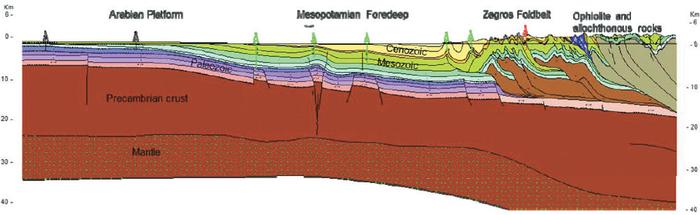
Figure 4 Regional geologic cross section, which extends NE across central Iraq, from the Arabian platform of southwestern Iraq, at the border with Saudi Arabia, across the Mesopotamian Foredeep and Zagros foldbelt in eastern Iraq and adjacent Iran, and ending at the Sirjan-Sanandaj zone in Iran.
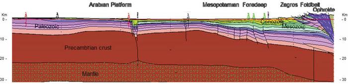
Figure 5 Regional geologic cross section which extends NE across western Iraq, from the Arabian platform at the border with Jordan, across the Mesopotamian Foredeep and Zagros foldbelt in northwestern Iraq, and ending in adjacent Turkey.


The main part of the Zagros foldbelt is topographically lower and is characterized by large anticlines trending to the northwest. In the southwestern part of the foldbelt, synclinal areas are covered by Neogene sediments. In the northwestern part of the foldbelt, Paleogene strata are exposed in synclines. The Zagros foldbelt forms a large structural embayment, called the Kirkuk embayment, in the overall Zagros foldbelt. Many oil and gas fields occur within this zone, as shown in Figure 3, including the super-giant Kirkuk field.
The central portion of Iraq is the Mesopotamian foredeep, an area of relatively deep-water deposition in the Mesozoic and Cenozoic that formed in front of, and which is less deformed than, the Zagros foldbelt (Figure 6). Structural features trend to the northwest in the Mesopotamian foredeep, parallel to the Zagros foldbelt trends, and are formed by both detached and basement-involved faults (Figure 4, Figure 6). Bouguer-gravity values are low in this foredeep (Figure 2), reflecting the thick sedimentary section. There are many oil and gas fields in the Mesopotamian foredeep (Figure 3), including the large East Baghdad field.

The southern part of the Mesopotamian foredeep is contiguous with the northern extension of the Gotnia Basin, an area of subsidence and deep-shelfal salt deposition during the Jurassic that extends into adjacent Kuwait. The Gotnia Basin (called the Zubair zone by Jassim and Goff[1]) is characterized by broad, low-angle anticlines that trend and plunge to the north. These anticlines form many oil and gas fields, including the super-giant Rumaila, West Qurna, Zubair, and Majnoon fields (Figure 3). Values of both Bouguer gravity and total magnetics are low (Figure 2), indicating a thick sedimentary sequence with a non-magnetic basement.
The Zagros foldbelt and Mesopotamian foredeep end at the Khleisia High (Rutbah subzone of Jassim and Goff[1]), a region of shallow basement and thin sedimentary cover, as interpreted from the high values of the Bouguer gravity map (Figure 2) and from the deep Khleisia 1 well which drilled to the Ordovician (Figure 5). Several east-trending extensional grabens that formed in the Late Cretaceous cut across and form the northern and southern boundaries of the Khleisia High (Figure 3). These include the Anah and Ashtar Grabens to the south (Figure 5), which appear as relatively low in the total magnetics map (Figure 2), and the inverted Sinjar Graben to the north, which is a low on Bouguer gravity. There are only a few small fields in northwestern Iraq (Figure 3).
Western and southern Iraq is part of the Arabian platform, a tectonically stable area which is only mildly deformed (Figure 4). The Ga’ara uplift in western Iraq is a large basement-involved high area where erosion has exposed Paleozoic strata. There are some small oil and gas discoveries on the Arabian platform in Iraq, mostly along the eastern edge, which is a structural monocline that flexes downward into the Mesopotamian foredeep (Figure 3). The most significant discovery is the Akkas field, located south of the Anah Graben, which contains gas in Paleozoic rocks.
Oil and gas fields[edit]
Table 1 lists the discoveries in Iraq (information in part from Jassim and Goff[1]; Verma et al.[3]), along with the hydrocarbon type and age of the main reservoir. The numbers refer to the locations of the fields as shown in Figure 3. Table 2 lists the fields by hydrocarbon type, structural province, structural style and trap type, source name, age and strata type, and volumes of in-place, estimated ultimate recoverable (EUR), produced, and remaining ultimate recoverable (RUR) oil and gas. The volumes data for oil and gas come mainly from Verma et al.[3] and Jassim and Goff,[1] except as noted in other references in this article.
| Field # | Field name | Hydrocarbon type | Age of main reservoirs | Field # | Field name | Hydrocarbon type | Age of main reservoirs | Field # | Field name | Hydrocarbon type | Age of main reservoirs | Field # | Field name | Hydrocarbon type | Age of main reservoirs |
|---|---|---|---|---|---|---|---|---|---|---|---|---|---|---|---|
| 1 | Tawake | Oil | Cretaceous | 31 | Chemchemal | Gas | Triassic | 61 | Tel Ghazal | Gas | Cenozoic | 91 | Nasiriyah | Oil | Cretaceous |
| 2 | Sufaiyah | Oil | Cretaceous | 32 | Kirkuk | Oil | Cenozoic | 62 | Balad | Oil | Cretaceous | 92 | Samawa | Oil | Cretaceous |
| 3 | Mushorah | Oil | Cretaceous | 33 | Ismail | Oil | Cenozoic | 63 | East Baghdad | Oil | Cretaceous | 93 | Diwan | Oil | Cretaceous |
| 4 | Boheira | Oil | Cretaceous | 34 | Bai Hassan | Oil | Cenozoic | 64 | Nahrawan | Oil | Cretaceous | 94 | Ghalaisan | Oil | Cretaceous |
| 5 | Abtakh | Oil | Cretaceous | 35 | Qara Chauq | Oil | Triassic | 65 | Fallujah | Oil | Cretaceous | 95 | Shawiyah | Oil | Cretaceous |
| 6 | Ain Zalah | Oil | Cretaceous | 36 | Khabbaz | Oil | Cenozoic | 66 | Nafatah | Oil | Cretaceous | 96 | Safawi | Oil | Cretaceous |
| 7 | Gullar | Oil | Cretaceous | 37 | Sadid | Oil | Cenozoic | 67 | Hit | Oil | Cenozoic | 97 | Ubaid | Oil | Cretaceous |
| 8 | Gusair | Oil | Cretaceous | 38 | Khanuqah | Oil | Cenozoic | 68 | Awasil | Oil | Cretaceous | 98 | Majnoon | Oil | Cretaceous |
| 9 | Jabal Kand | Oil | Cretaceous | 39 | Makhul | Oil | Jurassic | 69 | Abu Jir | Oil | Cretaceous | 99 | Nahr Umr/Bin Umar | Oil | |
| 10 | Raffan | Oil | Jurassic | 40 | Kor Mor | Gas | Cenozoic | 70 | Badrah | Oil | Cretaceous | 100 | Sindbad | Oil | Cenozoic |
| 11 | Butmah | Oil | Triassic | 41 | Jambur | Oil | Cenozoic | 71 | Dhafriya | Oil | Cretaceous | 101 | Siba | Oil | Cretaceous |
| 12 | Alan | Oil | Triassic | 42 | Pulkhana | Oil | Cenozoic | 72 | Ahdab | Oil | Cretaceous | 102 | Umm Qasr | Oil | Cretaceous |
| 13 | Sarjoon | Oil | Cretaceous | 43 | Judaida | Oil | Cenozoic | 73 | Afaq | Oil | Cretaceous | 103 | Zubair | Oil | Cretaceous |
| 14 | Ain Ghazal | Oil | Cenozoic | 44 | Hamrin | Oil | Cenozoic | 74 | Musaiyib | Oil | Cretaceous | 104 | Jabal Sanam | Oil | Cretaceous |
| 15 | Tel Hajar | Oil | Cenozoic | 45 | Ajil | Oil | Cenozoic | 75 | Kifl | Oil | Cretaceous | 105 | Tuba | Oil | Cretaceous |
| 16 | Ibrahim | Oil | Triassic | 46 | Tikrit | Oil | Cretaceous | 76 | West Kifl | Oil | Cretaceous | 106 | West Qurna | Oil | Cretaceous |
| 17 | Atshan | Oil | Triassic | 47 | Samarra | Oil | Cretaceous | 77 | Merjan | Oil | Cretaceous | 107 | Rumaila | Oil | Cretaceous |
| 18 | Adaiyah | Oil | Triassic | 48 | Mileh Tharthar | Oil | Triassic | 78 | Abu Ghirab | Oil | Cenozoic | 108 | Ratawi | Oil | Cretaceous |
| 19 | Qalian | Oil | Triassic | 49 | Khleisia | Gas | Paleozoic | 79 | Jabal Fauqi | Oil | Cenozoic | 109 | Subba | Oil | Cretaceous |
| 20 | Qasab | Oil | Cenozoic | 50 | Anah | Oil | Triassic | 80 | Buzurgan | Oil | Cretaceous | 110 | West Luhais | Oil | Cretaceous |
| 21 | Jawan | Oil | Cenozoic | 51 | Akkas | Gas | Paleozoic | 81 | Noor | Oil | Cretaceous | 111 | Luhais | Oil | Cretaceous |
| 22 | Najmah | Oil | Cenozoic | 52 | Chia Surkh | Oil | Cenozoic | 82 | Huwaiza | Oil | Cretaceous | 112 | Rachi | Oil | Cretaceous |
| 23 | Qaiyarah | Oil | Cenozoic | 53 | Qamar | Oil | Cenozoic | 83 | Halfayah | Oil | Cretaceous | 113 | Jerishan | Oil | Cretaceous |
| 24 | Hibbarah | Oil | Cenozoic | 54 | Gilabat | Oil | Cenozoic | 84 | Amara | Oil | Cretaceous | 114 | Khidr Al Maa | Oil | Cretaceous |
| 25 | Makhmour | Oil | Cretaceous | 55 | Injana | Oil | Cretaceous | 85 | Rifae | Oil | Cretaceous | 115 | Abu Kheima | Oil | Cretaceous |
| 26 | Hawler (Benenan) | Oil | Jurassic | 56 | Khashm Al Ahmar | Gas | Cenozoic | 86 | Muhainya | Oil | Cretaceous | 116 | Shaikan | Oil | Jurassic |
| 27 | Demirdagh | Oil | Cretaceous | 57 | Jaria Pika | Gas | Cenozoic | 87 | Kumait | Oil | Cretaceous | 117 | Miran West | Oil | Cretaceous |
| 28 | Quwair | Oil | Cenozoic | 58 | Nau Doman | Oil | Cenozoic | 88 | Dujaila | Oil | Cretaceous | 118 | Kurdamir | Gas | Cenozoic |
| 29 | Binabawi | Gas | Triassic | 59 | Naft Khaneh | Oil | Cenozoic | 89 | Rafidain | Oil | Cretaceous | 119 | Shakal | Oil | Cenozoic |
| 30 | Taq Taq | Oil | Cretaceous | 60 | Mansuriya | Gas | Cenozoic | 90 | Gharraf | Oil | Cretaceous | 120 | Bijeel | Oil | Jurassic |
| 121 | Bazian | Oil | Cretaceous |
Table 3 lists the reservoir horizons and seals in fields that have produced oil and gas. The same information is shown for undeveloped fields in Table 4 and for small discoveries and wells with shows in Table 6.

There are 107 oil discoveries and nine gas discoveries in Iraq. The majority of these are in the Zagros foldbelt (53), the Mesopotamian foredeep (22), and the Gotnia Basin (18), and they account for over 98% of the oil and gas discovered.
The oil discoveries contain recoverable reserves of about 137 billion barrels of oil (gbo) and 93 trillion cubic feet of gas (tcfg). The largest oil fields are Rumaila (30 gbo), Kirkuk (25 gbo), and East Baghdad (16 gbo). Oil (and minor condensate) is about 89% of the per-barrel oil equivalent in Iraq.
The nine gas discoveries contain recoverable reserves of about 13 tcfg and 280 million barrels of liquid (mbl). The largest gas fields are Mansuriya (3.3 tcfg) and Akkas (2.5 tcfg).
To date, about 25 gbo and 11 tcfg have been produced from about 23 fields. The most has been from the Kirkuk (about 14 gbo) and Rumaila (about 8 gbo) fields.
The major reservoirs in Iraq are Cretaceous, and these are the main reservoirs in 69 discoveries. The recoverable reserves in Cretaceous reservoirs in all fields are estimated to be between 59 and 101 gbo and 15 to 55 tcfg. Similar, there are 32 discoveries with mainly Cenozoic reservoirs, with 24–46 gbo and 14–41 tcfg recoverable in all Cenozoic reservoirs. Only 10 discoveries are mainly in Triassic reservoirs, with recoverable reserves of 400–500 mbo and up to 6 tcfg, and three discoveries mainly from Jurassic reservoirs, with 580–1500 mbo and no gas. Estimates of up to 6 tcfg of gas occur in the Paleozoic at Akkas field, with shows in Khleisia 1.
Several conclusions can be drawn from these data:
- Iraq is an oil province, with a lot of oil generated in superb source rocks.
- The Cretaceous and Cenozoic are the most important reservoir intervals, and there are fewer discoveries in Jurassic and older rocks.
- Some accumulations are very large, with large trap and reservoir volumes, commonly in stacked reservoir-seal pairs.
See also[edit]
- Phanerozoic Tethys region
- Israel petroleum systems
- Libya hydrocarbon provinces
- Tethys region
- Jordan petroleum geology
References[edit]
- ↑ 1.0 1.1 1.2 1.3 1.4 1.5 1.6 Jassim, S. Z. and Goff, J. C., 2006, Geology of Iraq: Dolin, Prague, and Moravian Museum, Brno, 341 p.
- ↑ Mohammed, S. A. G., 2006, Megaseismic section across the northeastern slope of the Arabian plate, Iraq: GeoArabia, v. 11, no. 4, p. 77–102.
- ↑ 3.0 3.1 3.2 Verma, M. K., Ahlbrandt, T. S., and Al-Gailani, M., 2004, Petroleum reserves and undiscovered resources in the total petroleum systems of Iraq: Reserve growth and production implications: GeoArabia, v. 9, no. 3, p. 51–74.
External links[edit]
| find literature about Iraq petroleum geology |