Difference between revisions of "San Juan basin"
m (added Category:Stubs using HotCat) |
Cwhitehurst (talk | contribs) |
||
| (3 intermediate revisions by the same user not shown) | |||
| Line 1: | Line 1: | ||
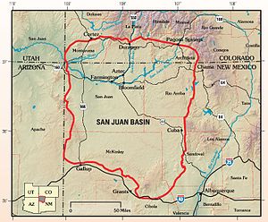
[[File:SanJuanBasinUSGS.jpg|thumb|300px|Map of San Juan Basin, Colorado-New Mexico, USA. U.S. Geological Survey.]] | [[File:SanJuanBasinUSGS.jpg|thumb|300px|Map of San Juan Basin, Colorado-New Mexico, USA. U.S. Geological Survey.]] | ||
| − | The San Juan basin is a structural depression in the northwest corner of New Mexico and in southern Colorado that encompasses about 35,000 km<sup>2</sup> (13,500 mi<sup>2</sup>). The [[basin]] contains deposits of [[natural gas]], [[oil]], [[coal]], [[uranium]], [[sand]], [[gravel]], [[limestone]], [[humate]], [[gypsum]], road metal, building stone, water, and paleoplacer concentrations of heavy minerals, and therefore has been of economic interest to industries for many decades. The structural geology of the basin bears directly on the distribution of most of these resources and their recovery, and has attracted much academic interest in its relationship to depositional and tectonic patterns in the western interior of the United States.<ref name=Thadenandzech_1986>Thaden, | + | The San Juan basin is a structural depression in the northwest corner of New Mexico and in southern Colorado that encompasses about 35,000 km<sup>2</sup> (13,500 mi<sup>2</sup>). The [[basin]] contains deposits of [[natural gas]], [[oil]], [[coal]], [[uranium]], [[sand]], [[gravel]], [[limestone]], [[humate]], [[gypsum]], road metal, building stone, water, and paleoplacer concentrations of heavy minerals, and therefore has been of economic interest to industries for many decades. The structural geology of the basin bears directly on the distribution of most of these resources and their recovery, and has attracted much academic interest in its relationship to depositional and tectonic patterns in the western interior of the United States.<ref name=Thadenandzech_1986>Thaden, R. E., and R. S. Zech, 1986, [http://archives.datapages.com/data/specpubs/mineral1/data/a179/a179/0001/0000/0035.htm Structure contour map of the San Juan basin and vicinity], in C. E. Turner-Peterson, E. S. Santos, and N. S. Fishman, A Basin Analysis Case Study: Morrison Formation, Grants Uranium Region, New Mexico: AAPG Studies in Geology 22, p. 35-45.</ref> |
| − | |||
| − | |||
| + | Although the structural basin dates back to the Paleozoic [[Era]],<ref name=Wengerdandmatheny_1958>Wengerd, S. A., and M. L. Matheny, 1958, [http://archives.datapages.com/data/bulletns/1957-60/data/pg/0042/0009/2000/2048.htm Pennsylvanian system of Four Corners region]: AAPG Bulletin, v. 42, p. 2048-2106.</ref> the present structural configuration is largely the result of [[Laramide]] [[deformation]] in the latest [[Cretaceous]] to early [[Tertiary]].<ref name=Kelley_1951>Kelley, V. C., 1951, Tectonics of the San Juan basin, ''in'' Guidebook of the south and west sides of the San Juan basin, New Mexico and Arizona, 2nd Field Conference: New Mexico Geological Society, p. 124-131.</ref><ref name=Thadenandzech_1986 /> [[Paleotectonic]] reconstructions have shown that the basinal axis shifted considerably in pre-Laramide time. The bounding [[uplift]]s at times were active and at times were quiescent. When active, the uplifts controlled the distribution of [[sediment]]s.<ref name=Santosandpeterson_1986>Santos, E. S., and C. E. Turner-Peterson, 1986, [http://archives.datapages.com/data/specpubs/mineral1/data/a179/a179/0001/0000/0027.htm Tectonic setting of the San Juan basin in the Jurassic], in C. E. Turner-Peterson, E. S. Santos, and N. S. Fishman, A Basin Analysis Case Study: Morrison Formation, Grants Uranium Region, New Mexico: AAPG Studies in Geology 22, p. 27-33.</ref> | ||
{{stub}} | {{stub}} | ||
| − | |||
==References== | ==References== | ||
Latest revision as of 15:01, 11 January 2016
The San Juan basin is a structural depression in the northwest corner of New Mexico and in southern Colorado that encompasses about 35,000 km2 (13,500 mi2). The basin contains deposits of natural gas, oil, coal, uranium, sand, gravel, limestone, humate, gypsum, road metal, building stone, water, and paleoplacer concentrations of heavy minerals, and therefore has been of economic interest to industries for many decades. The structural geology of the basin bears directly on the distribution of most of these resources and their recovery, and has attracted much academic interest in its relationship to depositional and tectonic patterns in the western interior of the United States.[1]
Although the structural basin dates back to the Paleozoic Era,[2] the present structural configuration is largely the result of Laramide deformation in the latest Cretaceous to early Tertiary.[3][1] Paleotectonic reconstructions have shown that the basinal axis shifted considerably in pre-Laramide time. The bounding uplifts at times were active and at times were quiescent. When active, the uplifts controlled the distribution of sediments.[4]
This article is a stub. You can help AAPG Wiki by expanding it.
References
- ↑ 1.0 1.1 Thaden, R. E., and R. S. Zech, 1986, Structure contour map of the San Juan basin and vicinity, in C. E. Turner-Peterson, E. S. Santos, and N. S. Fishman, A Basin Analysis Case Study: Morrison Formation, Grants Uranium Region, New Mexico: AAPG Studies in Geology 22, p. 35-45.
- ↑ Wengerd, S. A., and M. L. Matheny, 1958, Pennsylvanian system of Four Corners region: AAPG Bulletin, v. 42, p. 2048-2106.
- ↑ Kelley, V. C., 1951, Tectonics of the San Juan basin, in Guidebook of the south and west sides of the San Juan basin, New Mexico and Arizona, 2nd Field Conference: New Mexico Geological Society, p. 124-131.
- ↑ Santos, E. S., and C. E. Turner-Peterson, 1986, Tectonic setting of the San Juan basin in the Jurassic, in C. E. Turner-Peterson, E. S. Santos, and N. S. Fishman, A Basin Analysis Case Study: Morrison Formation, Grants Uranium Region, New Mexico: AAPG Studies in Geology 22, p. 27-33.
