Search results
Jump to navigation
Jump to search
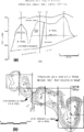
File:Subsurface-maps fig4.png (a) Cross section and (b) net pay Isopach map of the Strachan gas field, western Canada. Contour Interval is 100 ft. (Fro(890 × 1,386 (78 KB)) - 20:42, 14 January 2014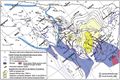
File:M106Ch14Fig13.jpg ...of the Arab reservoir before the Zagros folding, together with the isopach map of the Hanifa–Tuwaiq Mountain and Diyab source rocks (TOC in excess of 1%(700 × 464 (101 KB)) - 18:44, 12 July 2016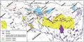
File:M106Ch14Fig12.jpg Cumulative isopach map from the base of the Kazhdumi Formation (Albian) to the top of the Mishan F(700 × 356 (74 KB)) - 19:40, 12 July 2016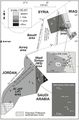
File:M106Ch07Fig04.jpg Isopach map of organic-rich Silurian shales with total gamma-ray values exceeding 150 A(564 × 855 (75 KB)) - 20:49, 18 April 2016
File:Mth14ch02f07.jpg Gross-sandstone isopach map of the Yowlumne sandstone showing separate depocenter thicks in Units A and(700 × 449 (53 KB)) - 19:56, 4 December 2015


