Surficial geochemical case history 2: stratigraphic trap
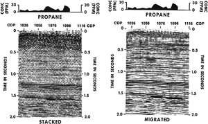
In this case history, the client conducted a soil gas hydrocarbon survey along the trace of the seismic line to look for evidence of hydrocarbon microseepage from a seismically defined trap at CDP 1070 (Figure 1). Propane soil gas anomalies were detected at CDP 1070 and 1096. The wildcat well drilled at CDP 1070 resulted in a new field discovery. The geochemical lead at CDP 1096 was reevaluated seismically. After additional processing, a revised interpretation (right) also predicted porosity development there and coincident with the surface geochemical anomaly. A second productive well was drilled at CDP 1096.

This is a good example, illustrating how we can use surface geochemical data to evaluate a geophysical lead and a geochemical lead.
Anomaly map
Figure 1 is a seismic section and soil gas profile of a stratigraphic trap located at approximately depth::5,600 ft (1.5 sec) in the Cretaceous Escondido Sandstone in La Salle County, Texas.
See also
External links
- ↑ Rice, G., 1989, Exploration Enhancement by integrating near-surface geochemical and seismic methods: Oil & Gas Journal, v. 87, no. 14 (April 3), p. 66-71.