Search results
Jump to navigation
Jump to search
Page title matches
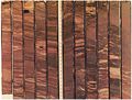
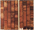
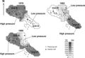
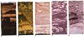
File:Charles-l-vavra-john-g-kaldi-robert-m-sneider capillary-pressure 2.jpg (1,200 × 828 (279 KB)) - 17:41, 13 September 2013
File:Charles-l-vavra-john-g-kaldi-robert-m-sneider capillary-pressure 3.jpg (1,200 × 1,041 (122 KB)) - 17:42, 13 September 2013
File:Charles-l-vavra-john-g-kaldi-robert-m-sneider capillary-pressure 5.jpg (1,200 × 670 (154 KB)) - 17:42, 13 September 2013
File:Charles-l-vavra-john-g-kaldi-robert-m-sneider capillary-pressure 4.jpg (1,200 × 923 (178 KB)) - 17:45, 13 September 2013
File:Charles-l-vavra-john-g-kaldi-robert-m-sneider capillary-pressure 1.jpg (1,200 × 434 (272 KB)) - 17:41, 13 September 2013


Page text matches
File:M91Ch13FG87.JPG ...Angus MacLellan). From Shepherd, M., 2009, Structural geology: Faults, in M. Shepherd, Oil field production geology: AAPG Memoir 91, p. 107-122.(600 × 396 (78 KB)) - 21:36, 29 April 2015
File:M91Ch6FG40.JPG Museum core on display. From Shepherd, M., 2009, Sources of data, in M. Shepherd, Oil field production geology: AAPG Memoir 91, p. 49-63.(600 × 402 (45 KB)) - 16:55, 3 June 2015
File:M91FG175.JPG ...o basin, Spain. From Shepherd, M., 2009, Meandering fluvial reservoirs, in M. Shepherd, Oil field production geology: AAPG Memoir 91, p. 261-272.(800 × 520 (107 KB)) - 19:54, 3 August 2015
File:M91FG170.JPG ...l, and sabkha environments. From Shepherd, M., 2009, Eolian reservoirs, in M. Shepherd, Oil field production geology: AAPG Memoir 91, p. 255-259.(800 × 670 (90 KB)) - 17:03, 29 July 2015
File:M31F24.jpg ...(approximately 10-m water depth) to bottom (water depth 60 m). Coleman, J. M., and D. B. Prior, 1981, Deltaic environments of deposition ''in'' P. A. Sc(758 × 947 (524 KB)) - 18:21, 18 August 2014
File:M91FG171.JPG ...y in eolian sediments. From From Shepherd, M., 2009, Eolian reservoirs, in M. Shepherd, Oil field production geology: AAPG Memoir 91, p. 255-259.(800 × 734 (138 KB)) - 17:18, 29 July 2015
File:H4CH12FG5.JPG ...g, 2012, Hicks, P. J. Jr., C. M. Fraticelli, J. D. Shosa, M. J. Hardy, and M. B. Townsley, ''in'' Peters, Kenneth E., David J. Curry, and Marek Kacewicz(600 × 707 (97 KB)) - 20:26, 9 July 2015
File:AlotaibiFigure3.jpg ...mage source: Abdul-Hamid M. Emwas, Zeyad A. Al-Talla, Yang Yang, and Najeh M. Kharbatia. (March 2012). Gas Chromatography–Mass Spectrometry of Bioflui(936 × 310 (48 KB)) - 21:23, 3 February 2022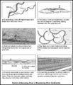
File:M91FG176.JPG ...iver sediments. From Shepherd, M., 2009, Meandering fluvial reservoirs, in M. Shepherd, Oil field production geology: AAPG Memoir 91, p. 261-272.(800 × 929 (161 KB)) - 20:28, 3 August 2015
File:M91Ch6FG48.JPG ...is required for further use). From Shepherd, M., 2009, Sources of data, in M. Shepherd, Oil field production geology: AAPG Memoir 91, p. 49-63.(600 × 428 (145 KB)) - 17:23, 3 June 2015
File:M91Ch13FG93.JPG ...of Structural Geology. Shepherd, M., 2009, Structural geology: Faults, in M. Shepherd, Oil field production geology: AAPG Memoir 91, p. 107-122.(600 × 704 (72 KB)) - 21:40, 29 April 2015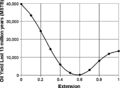
File:H4CH12FG10.JPG ...g, 2012, Hicks, P. J. Jr., C. M. Fraticelli, J. D. Shosa, M. J. Hardy, and M. B. Townsley, ''in'' Peters, Kenneth E., David J. Curry, and Marek Kacewicz(600 × 439 (52 KB)) - 21:21, 13 July 2015
File:M91Ch6FG42.JPG ...ter Caplan and Moslow, 1999). From Shepherd, M., 2009, Sources of data, in M. Shepherd, Oil field production geology: AAPG Memoir 91, p. 49-63.(800 × 942 (95 KB)) - 17:04, 3 June 2015
File:M91Ch6FG45.JPG ...to evaluate reservoir sweep. From Shepherd, M., 2009, Sources of data, in M. Shepherd, Oil field production geology: AAPG Memoir 91, p. 49-63.(800 × 838 (77 KB)) - 17:13, 3 June 2015
File:M91Ch13FG81.JPG ...e to fault cutout. From Shepherd, M., 2009, Structural geology: Faults, in M. Shepherd, Oil field production geology: AAPG Memoir 91, p. 107-122.(600 × 525 (31 KB)) - 21:15, 29 April 2015
File:M91Ch6FG47.JPG ...from the Geological Society. From Shepherd, M., 2009, Sources of data, in M. Shepherd, Oil field production geology: AAPG Memoir 91, p. 49-63.(600 × 758 (111 KB)) - 21:46, 29 April 2015
File:M91Ch2FG6.JPG ...hole before drilling further. From Shepherd, M., 2009, Drilling a well, in M. Shepherd, Oil field production geology: AAPG Memoir 91, p. 7-12.(800 × 847 (167 KB)) - 17:01, 22 April 2015
File:H4CH12FG2.JPG ...g, 2012, Hicks, P. J. Jr., C. M. Fraticelli, J. D. Shosa, M. J. Hardy, and M. B. Townsley, ''in'' Peters, Kenneth E., David J. Curry, and Marek Kacewicz(800 × 581 (246 KB)) - 20:11, 9 July 2015
File:M91Ch13FG90.JPG ...ing et al., 1997). From Shepherd, M., 2009, Structural geology: Faults, in M. Shepherd, Oil field production geology: AAPG Memoir 91, p. 107-122.(600 × 823 (51 KB)) - 21:39, 29 April 2015
File:M91FG187.JPG ...Petroleum Engineers. From From Shepherd, M., 2009, Deltaic reservoirs, in M. Shepherd, Oil field production geology: AAPG Memoir 91, p. 279-288.(800 × 620 (61 KB)) - 20:04, 13 August 2015
File:M91Ch13FG91.JPG ...rom Gibson, 1994). From Shepherd, M., 2009, Structural geology: Faults, in M. Shepherd, Oil field production geology: AAPG Memoir 91, p. 107-122.(600 × 736 (137 KB)) - 21:40, 29 April 2015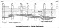
File:M91FG188.JPG ...the AAPG. GR = gamma ray. From Shepherd, M., 2009, Deltaic reservoirs, in M. Shepherd, Oil field production geology: AAPG Memoir 91, p. 279-288.(800 × 385 (54 KB)) - 16:21, 20 August 2015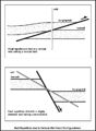
File:M91Ch13FG82.JPG ...ng a normal fault. From Shepherd, M., 2009, Structural geology: Faults, in M. Shepherd, Oil field production geology: AAPG Memoir 91, p. 107-122.(600 × 820 (92 KB)) - 21:16, 29 April 2015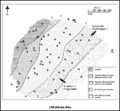
File:M91Ch11FG73.JPG ...from the Geological Society. From Shepherd, M., 2009, Lithofacies maps, in M. Shepherd, Oil field production geology: AAPG Memoir 91, p. 93-98.(800 × 738 (128 KB)) - 15:54, 27 April 2015
File:H4CH12FG3.JPG ...g, 2012, Hicks, P. J. Jr., C. M. Fraticelli, J. D. Shosa, M. J. Hardy, and M. B. Townsley, ''in'' Peters, Kenneth E., David J. Curry, and Marek Kacewicz(600 × 252 (67 KB)) - 20:14, 9 July 2015
File:M91Ch11FG70.JPG ...Texas (from Burnett, 1996). From Shepherd, M., 2009, Lithofacies maps, in M. Shepherd, Oil field production geology: AAPG Memoir 91, p. 93-98.(600 × 353 (134 KB)) - 15:46, 27 April 2015
File:M91Ch13FG86.JPG ...Sanderson, 1994). From Shepherd, M., 2009, Structural geology: Faults, in M. Shepherd, Oil field production geology: AAPG Memoir 91, p. 107-122.(600 × 444 (30 KB)) - 21:35, 29 April 2015
File:H4CH12FG12.JPG ...g, 2012, Hicks, P. J. Jr., C. M. Fraticelli, J. D. Shosa, M. J. Hardy, and M. B. Townsley, in Peters, Kenneth E., David J. Curry, and Marek Kacewicz, ed(600 × 346 (51 KB)) - 21:41, 13 July 2015
File:M91FG185.JPG ...www.earthobservatory.com). From Shepherd, M., 2009, Deltaic reservoirs, in M. Shepherd, Oil field production geology: AAPG Memoir 91, p. 279-288.(800 × 989 (133 KB)) - 18:40, 13 August 2015
File:H4CH12FG13.JPG ...g, 2012, Hicks, P. J. Jr., C. M. Fraticelli, J. D. Shosa, M. J. Hardy, and M. B. Townsley, in Peters, Kenneth E., David J. Curry, and Marek Kacewicz, ed(600 × 480 (128 KB)) - 21:42, 13 July 2015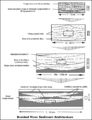
File:M91FG182.JPG ...ion from the AAPG. From Shepherd, M., 2009, Braided fluvial reservoirs, in M. Shepherd, Oil field production geology: AAPG Memoir 91, p. 273-277.(800 × 1,040 (126 KB)) - 18:47, 12 August 2015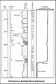
File:M91FG183.JPG ...ringer-Verlag Ltd. From Shepherd, M., 2009, Braided fluvial reservoirs, in M. Shepherd, Oil field production geology: AAPG Memoir 91, p. 273-277.(800 × 1,199 (103 KB)) - 19:00, 12 August 2015
File:M91FG178.JPG ...left to right. From Shepherd, M., 2009, Meandering fluvial reservoirs, in M. Shepherd, Oil field production geology: AAPG Memoir 91, p. 261-272.(800 × 1,042 (186 KB)) - 21:26, 3 August 2015
File:H4CH12FG11.JPG ...g, 2012, Hicks, P. J. Jr., C. M. Fraticelli, J. D. Shosa, M. J. Hardy, and M. B. Townsley, in Peters, Kenneth E., David J. Curry, and Marek Kacewicz, ed(600 × 322 (73 KB)) - 21:40, 13 July 2015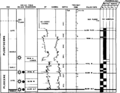
File:Paleontology fig1.png ...Globoquadrina altispira''. Paleoecological abbreviations: Bathy = bathyal, M = middle, U = upper, O = outer, I = inner. (From Armentrout, 1987.)(1,953 × 1,521 (104 KB)) - 17:48, 14 January 2014
File:H4CH12FG4.JPG ...g, 2012, Hicks, P. J. Jr., C. M. Fraticelli, J. D. Shosa, M. J. Hardy, and M. B. Townsley, ''in'' Peters, Kenneth E., David J. Curry, and Marek Kacewicz(600 × 369 (82 KB)) - 20:20, 9 July 2015
File:M91FG177.JPG ...ntary Geology). From Shepherd, M., 2009, Meandering fluvial reservoirs, in M. Shepherd, Oil field production geology: AAPG Memoir 91, p. 261-272.(800 × 765 (56 KB)) - 21:21, 3 August 2015
File:M91FG180.JPG ...from the AAPG. From Shepherd, M., 2009, Meandering fluvial reservoirs, in M. Shepherd, Oil field production geology: AAPG Memoir 91, p. 261-272.(800 × 474 (56 KB)) - 15:53, 10 August 2015
File:M91Ch13FG85.JPG ...rce et al., 2006). From Shepherd, M., 2009, Structural geology: Faults, in M. Shepherd, Oil field production geology: AAPG Memoir 91, p. 107-122.(600 × 303 (34 KB)) - 21:34, 29 April 2015
File:M91Ch13FG94.JPG ...om Edwards, 1976). From Shepherd, M., 2009, Structural geology: Faults, in M. Shepherd, Oil field production geology: AAPG Memoir 91, p. 107-122.(800 × 345 (49 KB)) - 21:41, 29 April 2015
File:M91Ch6FG41.JPG ...Geological Society of London. From Shepherd, M., 2009, Sources of data, in M. Shepherd, Oil field production geology: AAPG Memoir 91, p. 49-63.(600 × 835 (138 KB)) - 17:00, 3 June 2015
File:M91Ch13FG83.JPG ...ransient analysis. From Shepherd, M., 2009, Structural geology: Faults, in M. Shepherd, Oil field production geology: AAPG Memoir 91, p. 107-122.(600 × 749 (49 KB)) - 21:16, 29 April 2015
File:M91Ch6FG46.JPG ...ul in reducing the water cut. From Shepherd, M., 2009, Sources of data, in M. Shepherd, Oil field production geology: AAPG Memoir 91, p. 49-63.(800 × 607 (60 KB)) - 17:17, 3 June 2015
File:M91FG172.JPG ...w.earthasart.gsfc.nasa.gov. From Shepherd, M., 2009, Eolian reservoirs, in M. Shepherd, Oil field production geology: AAPG Memoir 91, p. 255-259.(800 × 1,164 (226 KB)) - 19:51, 29 July 2015
File:M91FG181.JPG ...ion from the AAPG. From Shepherd, M., 2009, Braided fluvial reservoirs, in M. Shepherd, Oil field production geology: AAPG Memoir 91, p. 273-277.(600 × 805 (104 KB)) - 21:18, 10 August 2015
File:M91Ch13FG89.JPG ...aposition sealing. From Shepherd, M., 2009, Structural geology: Faults, in M. Shepherd, Oil field production geology: AAPG Memoir 91, p. 107-122.(600 × 632 (54 KB)) - 21:38, 29 April 2015
File:M91Ch6FG43.JPG ...is required for further use. From Shepherd, M., 2009, Sources of data, in M. Shepherd, Oil field production geology: AAPG Memoir 91, p. 49-63.(800 × 827 (107 KB)) - 17:07, 3 June 2015
File:M91FG173.JPG ...from the AAPG. From Shepherd, M., 2009, Meandering fluvial reservoirs, in M. Shepherd, Oil field production geology: AAPG Memoir 91, p. 261-272.(800 × 878 (161 KB)) - 16:11, 31 July 2015
File:M91Ch11FG69.JPG ...a billion-barrel oil field. From Shepherd, M., 2009, Lithofacies maps, in M. Shepherd, Oil field production geology: AAPG Memoir 91, p. 93-98.(600 × 606 (106 KB)) - 15:42, 27 April 2015
File:M31F25.jpg ...ical scale is 10 milliseconds per time line, or 7.6 m (25 ft). Coleman, J. M., and D. B. Prior, 1981, Deltaic environments of deposition ''in'' P. A. Sc(1,087 × 1,348 (940 KB)) - 18:21, 18 August 2014
File:Mth14ch04f01.jpg ...t South Pass 62 Salt-dome Field, by E. P. Mason, M. J. Bastian, R. Detomo, M. N. Hashem, and A. J. Hildebrandt, Pages 49 - 65, ''in'' AAPG Methods in Ex(700 × 525 (111 KB)) - 16:00, 7 December 2015
File:M91Ch2.JPG ...ones required for production. From Shepherd, M., 2009, Drilling a well, in M. Shepherd, Oil field production geology: AAPG Memoir 91, p. 7-12.(800 × 831 (175 KB)) - 21:14, 22 April 2015
File:M91Ch2FG5.JPG ...y Ltd. (www.woodside.com.au). From Shepherd, M., 2009, Drilling a well, in M. Shepherd, Oil field production geology: AAPG Memoir 91, p. 7-12.(600 × 606 (66 KB)) - 16:49, 22 April 2015
File:H4CH12FG8.JPG ...g, 2012, Hicks, P. J. Jr., C. M. Fraticelli, J. D. Shosa, M. J. Hardy, and M. B. Townsley, ''in'' Peters, Kenneth E., David J. Curry, and Marek Kacewicz(600 × 372 (49 KB)) - 20:32, 13 July 2015
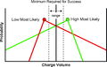
File:M91Ch2FG4.JPG ...k cuttings up to the surface. From Shepherd, M., 2009, Drilling a well, in M. Shepherd, Oil field production geology: AAPG Memoir 91, p. 7-12.(800 × 1,046 (200 KB)) - 16:45, 22 April 2015- ...5/a095/0001/0200/0221.htm Capillary pressure] in D. Morton-Thompson and A. M. Woods, eds., Development Geology Reference Manual: [http://store.aapg.org/557 bytes (82 words) - 14:13, 24 July 2014
File:H4CH12FG1.JPG ...g, 2012, Hicks, P. J. Jr., C. M. Fraticelli, J. D. Shosa, M. J. Hardy, and M. B. Townsley, in Peters, Kenneth E., David J. Curry, and Marek Kacewicz, ed(600 × 378 (60 KB)) - 19:59, 9 July 2015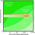
File:CO2TrappingMechanisms.JPG ...ogical input to selection and evaluation of CO2 geosequestration sites, in M. Grobe, J. C. Pashin, and R. L. Dodge, eds., Carbon dioxide sequestration i(600 × 596 (131 KB)) - 18:25, 7 August 2014
File:M91FG174.JPG ...physical Union. From Shepherd, M., 2009, Meandering fluvial reservoirs, in M. Shepherd, Oil field production geology: AAPG Memoir 91, p. 261-272.(800 × 639 (117 KB)) - 16:13, 31 July 2015
File:M91Ch11FG72.JPG ...otential log; GR = gamma-ray log. Shepherd, M., 2009, Lithofacies maps, in M. Shepherd, Oil field production geology: AAPG Memoir 91, p. 93-98.(800 × 658 (69 KB)) - 15:51, 27 April 2015
File:H4CH12FG7.JPG ...g, 2012, Hicks, P. J. Jr., C. M. Fraticelli, J. D. Shosa, M. J. Hardy, and M. B. Townsley, ''in'' Peters, Kenneth E., David J. Curry, and Marek Kacewicz(600 × 599 (51 KB)) - 21:12, 9 July 2015
File:M91FG189.JPG ...permission from the AAPG. From Shepherd, M., 2009, Deltaic reservoirs, in M. Shepherd, Oil field production geology: AAPG Memoir 91, p. 279-288.(800 × 544 (102 KB)) - 16:57, 20 August 2015
File:M91Ch13FG80.JPG ...y of Schlumberger. From Shepherd, M., 2009, Structural geology: Faults, in M. Shepherd, Oil field production geology: AAPG Memoir 91, p. 107-122.(800 × 660 (102 KB)) - 21:14, 29 April 2015
File:M91FG123.png ...mission from the AAPG. From Shepherd, M., 2009, Geostatistical methods, in M. Shepherd, Oil field production geology: AAPG Memoir 91, p. 159–174.(2,064 × 2,095 (121 KB)) - 19:40, 13 August 2015
File:CO2StorageOptions.JPG ...ogical input to selection and evaluation of CO2 geosequestration sites, in M. Grobe, J. C. Pashin, and R. L. Dodge, eds., Carbon dioxide sequestration i(800 × 570 (244 KB)) - 17:26, 7 August 2014
File:M91FG186.JPG ...ourtesy of the AAPG). From From Shepherd, M., 2009, Deltaic reservoirs, in M. Shepherd, Oil field production geology: AAPG Memoir 91, p. 279-288.(800 × 1,137 (157 KB)) - 19:22, 13 August 2015
File:M91FG184.JPG ...with permission from AAPG. From Shepherd, M., 2009, Deltaic reservoirs, in M. Shepherd, Oil field production geology: AAPG Memoir 91, p. 279-288.(800 × 1,134 (191 KB)) - 20:10, 12 August 2015
File:M91Ch13FG92.JPG ...eological Society. From Shepherd, M., 2009, Structural geology: Faults, in M. Shepherd, Oil field production geology: AAPG Memoir 91, p. 107-122.(600 × 517 (60 KB)) - 21:40, 29 April 2015
File:M91Ch06FG44.JPG ...res as a result of depletion. From Shepherd, M., 2009, Sources of data, in M. Shepherd, Oil field production geology: AAPG Memoir 91, p. 49-63.(800 × 696 (58 KB)) - 17:11, 3 June 2015
File:M91FG179.JPG ..., Springer Ltd. From Shepherd, M., 2009, Meandering fluvial reservoirs, in M. Shepherd, Oil field production geology: AAPG Memoir 91, p. 261-272.(800 × 984 (103 KB)) - 21:50, 3 August 2015
File:H4CH12FG9.JPG ...g, 2012, Hicks, P. J. Jr., C. M. Fraticelli, J. D. Shosa, M. J. Hardy, and M. B. Townsley, ''in'' Peters, Kenneth E., David J. Curry, and Marek Kacewicz(800 × 262 (80 KB)) - 20:34, 13 July 2015
File:BLTN12220fig5.jpg ...petroleum inclusions were found in gas-stage TSR calcite, well D4, 4793.00 m (15,721.04 ft). From Thermochemical sulfate reduction and fluid evolution o(444 × 500 (324 KB)) - 13:22, 13 August 2014
File:M91Ch11FG71.JPG ...from Hamilton et al., 2002). From Shepherd, M., 2009, Lithofacies maps, in M. Shepherd, Oil field production geology: AAPG Memoir 91, p. 93-98.(800 × 629 (79 KB)) - 15:48, 27 April 2015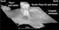
File:Mth14ch04f04.jpg ...t South Pass 62 Salt-dome Field, by E. P. Mason, M. J. Bastian, R. Detomo, M. N. Hashem, and A. J. Hildebrandt, Pages 49 - 65, in AAPG Methods in Explor(400 × 202 (17 KB)) - 16:51, 7 December 2015
File:Mth14ch07f02.jpg ...dhoe Bay Field, Alaska , by R. S. Tye, B. A. Watson, P. L. McGuire, and M. M. Maguire, Pages 113 - 125, in AAPG Methods in Exploration No. 14: Horizonta(500 × 923 (106 KB)) - 17:50, 7 December 2015
File:Mth14ch04f03.jpg ...t South Pass 62 Salt-dome Field, by E. P. Mason, M. J. Bastian, R. Detomo, M. N. Hashem, and A. J. Hildebrandt, Pages 49 - 65, in AAPG Methods in Explor(500 × 495 (47 KB)) - 16:09, 7 December 2015
File:M91Ch13FG84.JPG ...eological Society. From Shepherd, M., 2009, Structural geology: Faults, in M. Shepherd, Oil field production geology: AAPG Memoir 91, p. 107-122.(600 × 766 (134 KB)) - 21:34, 29 April 2015- ...amu.edu/publications/tnotes/tn30/tn30_2.htm Ocean Drilling Program Texas A&M University article]258 bytes (35 words) - 16:37, 27 March 2015
File:Mth14ch07f04.jpg ...dhoe Bay Field, Alaska , by R. S. Tye, B. A. Watson, P. L. McGuire, and M. M. Maguire, Pages 113 - 125, in AAPG Methods in Exploration No. 14: Horizonta(500 × 258 (39 KB)) - 17:58, 7 December 2015
File:M91Ch13FG88.JPG ...lof et al., 2004). From Shepherd, M., 2009, Structural geology: Faults, in M. Shepherd, Oil field production geology: AAPG Memoir 91, p. 107-122.(600 × 585 (272 KB)) - 21:36, 29 April 2015
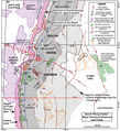
File:M115CH10FG02.jpg ...structural spill point to the west. Depth contours shown are in 100 ft (30 m) TVD increments. Area of map is shown in [[Kingfisher field|Figure 1]]. Fro(1,283 × 1,132 (1.55 MB)) - 18:38, 17 January 2019
File:Mth14ch04f06.jpg ...t South Pass 62 Salt-dome Field, by E. P. Mason, M. J. Bastian, R. Detomo, M. N. Hashem, and A. J. Hildebrandt, Pages 49 - 65, in AAPG Methods in Explor(800 × 563 (141 KB)) - 16:55, 7 December 2015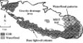
File:Mth14ch07f05.jpg ...dhoe Bay Field, Alaska , by R. S. Tye, B. A. Watson, P. L. McGuire, and M. M. Maguire, Pages 113 - 125, in AAPG Methods in Exploration No. 14: Horizonta(500 × 264 (41 KB)) - 18:09, 7 December 2015
File:H4CH12FG6.JPG ...g, 2012, Hicks, P. J. Jr., C. M. Fraticelli, J. D. Shosa, M. J. Hardy, and M. B. Townsley, ''in'' Peters, Kenneth E., David J. Curry, and Marek Kacewicz(600 × 611 (85 KB)) - 21:07, 9 July 2015
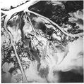
File:M31F1.jpg ...a delta system. From Deltaic environments of deposition, 1981, Coleman, J. M., and D. B. Prior, in AAPG Memoir 31.(744 × 591 (256 KB)) - 18:15, 15 August 2014
File:Mth14ch04f05.jpg ...t South Pass 62 Salt-dome Field, by E. P. Mason, M. J. Bastian, R. Detomo, M. N. Hashem, and A. J. Hildebrandt, Pages 49 - 65, in AAPG Methods in Explor(700 × 469 (63 KB)) - 16:53, 7 December 2015
File:M91FG190.JPG ...permission from the AAPG. From Shepherd, M., 2009, Deltaic reservoirs, in M. Shepherd, Oil field production geology: AAPG Memoir 91, p. 279-288.(800 × 1,047 (162 KB)) - 18:05, 20 August 2015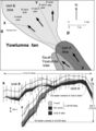
File:Mth14ch02f05.jpg ...ural relief between oil-water contacts in the lobes of Units A and B. From M. S. Clark, R. K. Prather, J. D. Melvin, 2003, Characterization and Exploita(500 × 682 (64 KB)) - 17:07, 4 December 2015
File:M31F4.jpg ...t-bar deposits. From Deltaic environments of deposition, 1981, Coleman, J. M., and D. B. Prior, in AAPG Memoir 31.(1,464 × 916 (326 KB)) - 19:19, 15 August 2014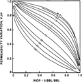
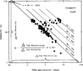
File:Waterflooding fig3.png Vertical sweep efficiency (coverage) as a function of WOR, ''M'', and permeability variation (''V''<sub>DP</sub>), where WOR = 5. (From Dy(949 × 944 (54 KB)) - 19:18, 14 January 2014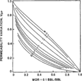
File:Waterflooding fig4.png Vertical sweep efficiency (coverage) as a function of WOR, ''M'', and permeability variation (''V''<sub>DP</sub>), where WOR = 0.1. (From(937 × 927 (20 KB)) - 19:18, 14 January 2014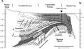
File:Mth14ch07f03.jpg ...dhoe Bay Field, Alaska , by R. S. Tye, B. A. Watson, P. L. McGuire, and M. M. Maguire, Pages 113 - 125, in AAPG Methods in Exploration No. 14: Horizonta(700 × 409 (77 KB)) - 17:55, 7 December 2015
File:Mth14ch07f01.jpg ...dhoe Bay Field, Alaska , by R. S. Tye, B. A. Watson, P. L. McGuire, and M. M. Maguire, Pages 113 - 125, ''in'' AAPG Methods in Exploration No. 14: Horiz(700 × 809 (135 KB)) - 17:34, 7 December 2015
File:Difficult-lithologies fig1.png M-N crossplot for mineral identification. Copyright: Schlumberger Well Servic(950 × 1,231 (43 KB)) - 01:11, 14 January 2014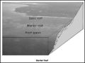
File:M91FG198.JPG ..., Bahamas. The back reef between the barrier reef and the shoreline is 700 m (2296 ft) wide.(800 × 602 (59 KB)) - 13:10, 20 August 2015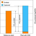
File:CO2EmissionsComparison.JPG ...ogical input to selection and evaluation of CO2 geosequestration sites, in M. Grobe, J. C. Pashin, and R. L. Dodge, eds., Carbon dioxide sequestration i(600 × 600 (75 KB)) - 16:14, 7 August 2014
File:M31F6.jpg ...er delta plain. From Deltaic environments of deposition, 1981, Coleman, J. M., and D. B. Prior, in AAPG Memoir 31.(1,467 × 1,013 (318 KB)) - 19:40, 15 August 2014
File:M31F3.jpg ...p photographs). From Deltaic environments of deposition, 1981, Coleman, J. M., and D. B. Prior, in AAPG Memoir 31.(2,941 × 1,884 (830 KB)) - 19:02, 15 August 2014- | author = Grant M. Skerlec ...a 100-m column of oil might leak if the column increased to [[length::101 m]].2 KB (266 words) - 15:45, 31 March 2022
- ...and is what is displayed on a sonic log, usually in units of μs/ft or μs/m. It is also seen as ''delta t'' or ''Δt''.205 bytes (40 words) - 20:03, 14 April 2014
File:Mth14ch04f02.jpg ...t South Pass 62 Salt-dome Field, by E. P. Mason, M. J. Bastian, R. Detomo, M. N. Hashem, and A. J. Hildebrandt, Pages 49 - 65, in AAPG Methods in Explor(500 × 718 (88 KB)) - 16:08, 7 December 2015
File:Mth14ch02f08.jpg ...uhas Talukdar, Core Laboratories, Inc., written communication, 1998). From M. S. Clark, R. K. Prather, J. D. Melvin, 2003, Characterization and Exploita(400 × 465 (28 KB)) - 20:19, 4 December 2015
File:M31F16.jpg ...furcating distributary channel in the Mississippi River delta. Coleman, J. M., and D. B. Prior, 1981, Deltaic environments of deposition ''in'' P. A. Sc(356 × 353 (54 KB)) - 18:14, 18 August 2014- ...in the Paraná basin, which displays large-scale sets of cross strata (1-30 m; [[:file:Botucatu_1.jpg|Figure 1]]), formed in a desert environment similar3 KB (432 words) - 17:54, 22 March 2019
File:M31F26.jpg ...aracteristics of slump deposits in the subaqueous delta plain. Coleman, J. M., and D. B. Prior, 1981, Deltaic environments of deposition ''in'' P. A. Sc(1,499 × 968 (531 KB)) - 18:22, 18 August 2014- [[File:Vápeč_od_Horn%C3%AD_Poruby.jpg|thumb|300px|Vápeč Hill (955 m), Strážovské vrchy Mountains, District Ilava, Slovakia. Highest part of391 bytes (57 words) - 16:04, 2 June 2015

File:SiteCharacterization.JPG ...ation methodology for the geological storage of CO2. From Gibson-Poole, C. M., 2009, Site characterization for geological storage of carbon dioxide: Exa(600 × 723 (218 KB)) - 19:10, 7 August 2014
File:M31F9.jpg ...acteristics of the bay-fill deposits in the lower delta plain. Coleman, J. M., and D. B. Prior, 1981, Deltaic environments of deposition in P. A. Scholl(1,510 × 990 (305 KB)) - 15:13, 18 August 2014
File:M31F13.jpg ...the abandoned distributary deposits in the lower delta plain. Coleman, J. M., and D. B. Prior, 1981, Deltaic environments of deposition in P. A. Scholl(1,508 × 950 (293 KB)) - 15:16, 18 August 2014
File:M31F22.jpg ...iver-mouth tidal ridge deposits in the subaqueous delta plain. Coleman, J. M., and D. B. Prior, 1981, Deltaic environments of deposition ''in'' P. A. Sc(1,416 × 989 (554 KB)) - 18:20, 18 August 2014
File:M31F17.jpg ...distributary-mouth bar deposits in the subaqueous delta plain. Coleman, J. M., and D. B. Prior, 1981, Deltaic environments of deposition ''in'' P. A. Sc(1,519 × 957 (150 KB)) - 18:17, 18 August 2014
File:M31F29.jpg ...the continental shelf off the modern Mississippi River delta. Coleman, J. M., and D. B. Prior, 1981, Deltaic environments of deposition ''in'' P. A. Sc(1,161 × 1,502 (970 KB)) - 18:25, 18 August 2014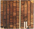
File:M31F15.jpg ...s, Mississippi River delta. Diameter of cores is 8 cm (3 in.). Coleman, J. M., and D. B. Prior, 1981, Deltaic environments of deposition in P. A. Scholl(1,194 × 1,001 (1.91 MB)) - 15:17, 18 August 2014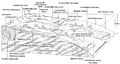
File:M31F23.jpg ...apirs, and contemporary faults in the Mississippi River delta. Coleman, J. M., and D. B. Prior, 1981, Deltaic environments of deposition ''in'' P. A. Sc(1,476 × 791 (905 KB)) - 18:20, 18 August 2014- ...ent Geology Reference Manual.'' Edited by Diana Morton-Thompson and Arnold M Woods. AAPG: Tulsa, USA.2 members (2 subcategories, 0 files) - 17:26, 9 October 2013
File:M31F8.jpg ...nment in the lower delta plain of the Mississippi River delta. Coleman, J. M., and D. B. Prior, 1981, Deltaic environments of deposition in P. A. Scholl(744 × 752 (412 KB)) - 15:12, 18 August 2014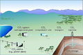
File:GeosequestrationProcess.JPG ...n and Evaluation of CO2 Geosequestration Sites by John G. Kaldi, Catherine M. Gibson-Poole, Tobias H. D. Payenberg, AAPG Studies in Geology 59, Carbon d(600 × 399 (131 KB)) - 15:54, 7 August 2014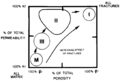
File:Evaluating-fractured-reservoirs fig1.png ...ractured reservoir types 1 through 3 and normal matrix reservoirs (<italic>m</italic>) in the percentage of porosity and permeability space. Symbols: <i(942 × 642 (23 KB)) - 15:00, 14 January 2014- | author = Grant M. Skerlec ...[[hydrocarbon column]]. Seals can be extremely thin—less than [[length::1 m]] thick that seal individual hydrocarbon [[accumulation]]s. There are also3 KB (464 words) - 20:56, 31 March 2022
File:M115CH02FG03.jpg ...EB = East Brae; G = Gudrun; JS = John Sverdrup; K = Kingfisher; L = Larch; M = Miller; NB = North Brae; SB = South Brae; S = Sycamore; Th = Thelma; Ti =(700 × 767 (157 KB)) - 21:29, 10 January 2019- * Burger, H., R., Hamill, M., 1976, Petrofabric analysis of the Dry Creek Ridge anticline, Montana: Geo * Burkhard, M., 1993, Calcite twins, their geometry, appearance and significance as stres4 KB (447 words) - 15:17, 3 February 2022
File:Log-analysis-applications fig5.png ...ub>w</sub> = 100%). This line identifies the cementation exponent (<italic>m</italic>) and the product of a × <italic>R</italic><sub><italic>w</italic>(929 × 801 (40 KB)) - 16:36, 14 January 2014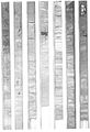
File:M31F11.jpg ...istal end of the bay infill. Diameter of core is 8 cm (3 in.). Coleman, J. M., and D. B. Prior, 1981, Deltaic environments of deposition in P. A. Scholl(951 × 1,393 (675 KB)) - 15:15, 18 August 2014- | author = Grant M. Skerlec ...me=ch10r27>England, W., A., Mackenzie, A., S., Mann, D., M., Quickley, T., M., 1987, The movement and entrapment of petroleum fluids in the subsurface:2 KB (313 words) - 13:57, 1 April 2022
- ...era as indicators of organic carbon flux, in M. A. Kaminski, S Geroch, and M. A. Gasiński, eds., Proceedings of the Fourth International Workshop on Ag4 KB (468 words) - 15:16, 31 January 2022
File:M31F19.jpg ...of the distal bar deposit. Diameter of cores is 8 cm (3 in.). Coleman, J. M., and D. B. Prior, 1981, Deltaic environments of deposition ''in'' P. A. Sc(1,343 × 1,017 (615 KB)) - 18:17, 18 August 2014- | author = Grant M. Skerlec ...nsylvania, SEALS International, 3948 p.</ref><ref name=ch10r74>Skerlec, G. M., 1997b, Atlas of fault seal behavior in the Gulf Coast: Franklin, Pennsylv4 KB (598 words) - 19:47, 24 March 2022
- | author = Grant M. Skerlec ...tion Research Company internal report.</ref><ref name=ch10r71>Skerlec, G., M., 1990, SEALS: A short course for risking top seal and fault seal: Franklin3 KB (403 words) - 15:21, 30 March 2022
File:M31F12.jpg ...rt of the bay-fill sequence. Diameter of core is 8 cm (3 in.). Coleman, J. M., and D. B. Prior, 1981, Deltaic environments of deposition in P. A. Scholl(946 × 1,383 (664 KB)) - 15:15, 18 August 2014- # Determine ''m'' using the table of values. ==Step 3: Determine ''m''==6 KB (878 words) - 16:16, 5 April 2022
File:M31F20.jpg ...ributary-mouth bar deposit. Diameter of cores is 8 cm (3 in.). Coleman, J. M., and D. B. Prior, 1981, Deltaic environments of deposition ''in'' P. A. Sc(1,158 × 1,014 (1.94 MB)) - 18:18, 18 August 2014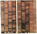
File:M31F21.jpg ...ibutary-mouth bar deposits. Diameter of cores is 8 cm (3 in.). Coleman, J. M., and D. B. Prior, 1981, Deltaic environments of deposition ''in'' P. A. Sc(1,120 × 1,026 (1.69 MB)) - 18:19, 18 August 2014
File:M31F28.jpg ...and capped by marine clays. Diameter of cores is 8 cm (3 in.). Coleman, J. M., and D. B. Prior, 1981, Deltaic environments of deposition ''in'' P. A. Sc(1,230 × 1,012 (1.84 MB)) - 18:24, 18 August 2014- | author = Grant M. Skerlec ...G Bulletin, vol. 81, no. 6, p. 897–917.</ref><ref name=ch10r74>Skerlec, G. M., 1997, Atlas of fault seal behavior in the Gulf Coast: Franklin, Pennsylva3 KB (471 words) - 21:50, 28 March 2022
- :<math>\mbox{R} = {-}(\mbox{k} \times \mbox{A/m} \times [(\mbox{P}_{\rm grad} + \mbox{P}_{\rm c}) - \rho_{\rm hc} \times \m * R = rate of migration (m<sup>3</sup>/sec)4 KB (618 words) - 19:40, 14 February 2022
- | author = Grant M. Skerlec ...carbon in the field in the Tar Springs Formation reservoir is [[length::29 m]] [[depth::(95 ft]]).4 KB (587 words) - 13:36, 1 April 2022
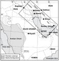
File:M106Ch14Fig01.jpg ...rops surrounding the Arabian shield are indicated. 200 km (124.3 mi). From M. L. Bordenave, 2014, Petroleum Systems and Distribution of the Oil and Gas(641 × 662 (94 KB)) - 18:05, 12 July 2016
File:M106Ch14Fig12.jpg ...nal highs as they appear before the Zagros folding. 100 km (62.1 mi). From M. L. Bordenave, 2014, Petroleum Systems and Distribution of the Oil and Gas(700 × 356 (74 KB)) - 19:40, 12 July 2016
File:M91FG199.JPG ...onate tidal flat on Andros Island, Bahamas. The tidal channel is about 150 m (492 ft) wide at the bottom of the photograph. The lower diagram shows thre(800 × 1,089 (126 KB)) - 13:11, 20 August 2015
File:M106Ch14Fig02.jpg ...Foothills and contiguous offshore (after Bordenave and Hegre, 2005). From M. L. Bordenave, 2014, Petroleum Systems and Distribution of the Oil and Gas(700 × 357 (77 KB)) - 18:08, 12 July 2016
File:M31F5.jpg ...t-bar deposits. From Deltaic environments of deposition, 1981, Coleman, J. M., and D. B. Prior, in AAPG Memoir 31.(1,152 × 941 (941 KB)) - 19:33, 15 August 2014
File:BasinCenteredGasFig4.jpg ...e field area to inside the field area ranges from 2500 to 3000 ft (762-914 m) (Warner, 1998). Figure modified from Warner (1998). From Law, Ben E., 2002(600 × 783 (79 KB)) - 22:22, 13 January 2015
File:M106Ch14Fig14.jpg ...he Mesopotamian depression area are also indicated. 100 km (62.1 mi). From M. L. Bordenave, 2014, Petroleum Systems and Distribution of the Oil and Gas(700 × 402 (73 KB)) - 19:35, 12 July 2016
File:M106Ch14Fig07.jpg ...han (data from Setudehnia, 1973; Huber, 1978; Ghavidel Syooki, 2003). From M. L. Bordenave, 2014, Petroleum Systems and Distribution of the Oil and Gas(700 × 567 (117 KB)) - 18:19, 12 July 2016- | author = John M. Armentrout ...ld: Pliocene-Pleistocene, northwestern Gulf of Mexico ''in'' P. Weimer and M. J. Link, eds., Seismic facies and sedimentary processes of submarine fans6 KB (850 words) - 15:33, 23 March 2022
- ...D. A., 2002, Volcanology and facies architecture of flood basalts, ''in'' M. A. Menzies, S. L. Klemperer, C. J. Ebinger, and J. Baker, eds., Magmatic r ...magma types:<ref name=Peate_1992>Peate, D. W., C. J. Hawkeswort, and M. S. M. Mantovani, 1992, Chemical stratigraphy of the Parana lavas (South America)6 KB (922 words) - 19:45, 11 April 2019
- | author = Diana Morton-Thompson and Arnold M. Woods124 members (0 subcategories, 0 files) - 16:26, 18 January 2022
File:M31F2.jpg ...nd laminations. From Deltaic environments of deposition, 1981, Coleman, J. M., and D. B. Prior, in AAPG Memoir 31.(365 × 772 (175 KB)) - 18:56, 15 August 2014- ...evidence.<ref name=ch21r47>Van Wagoner, J. C., Mitchum, R. M., Campion, K. M., Rahmanian, V. D., 1990, Siliciclastic Sequence stratigraphy in Well Logs, ! Sequence order || Cycle frequency, m.y. || Thickness, m || Stratigraphic name3 KB (380 words) - 22:25, 3 February 2022
- ...essure]] (''P''<sub>b</sub> ) at the depth of the measured pressure (P<sub>m</sub> ) from the measured pressure: #*:<math>P_{\rm b} = P_{\rm m} - P_{\rm hydrostatic}</math>3 KB (463 words) - 17:54, 17 February 2022
- As part of my reformat, I'm taking out references to other chapters (e.g. "For an example and explanati473 bytes (73 words) - 20:07, 21 May 2014
File:M106Ch14Fig11.jpg ...he Mesopotamian depression area are also indicated. 100 km (62.1 mi). From M. L. Bordenave, 2014, Petroleum Systems and Distribution of the Oil and Gas(700 × 422 (79 KB)) - 18:36, 12 July 2016- ...ula <math>\text{V} = \text{A} \times \text{T} \times \text{Y} \times \text{M}</math>, where: #* ''M'' = migration efficiency6 KB (834 words) - 20:41, 14 February 2022
- | author = Grant M. Skerlec ...trolled instead by fault-dependent leak points.<ref name=ch10r3>Allard, D. M., 1993, Fault leak controlled trap fill, rift basin examples (abs.), in J.4 KB (556 words) - 20:56, 31 March 2022
- :<math>\mbox{S}_{\rm w} = \left(\frac{1}{\Phi^{\rm m}} \times \frac{\mbox{R}_{\rm w}}{\mbox{R}_{\rm t}}\right)^{\rm 1/n}</math> * m = cementation exponent, which varies from 1.7 to 3.0 but normally is 2.04 KB (528 words) - 13:53, 4 April 2022
File:Mth14ch02f03.jpg ...ty decreases from the axis of the fan eastward toward the fan margin. From M. S. Clark, R. K. Prather, J. D. Melvin, 2003, Characterization and Exploita(700 × 529 (75 KB)) - 15:26, 4 December 2015- | author = John M. Armentrout ...field: Pliocene–Pleistocene, northwestern Gulf of Mexico, in P. Weimer and M. J. Link, eds., Seismic Facies and Sedimentary Processes of Submarine Fans5 KB (662 words) - 14:48, 19 December 2023
- ...ut too tight to produce. Between these are [[length::30 ft]] [[depth::(8.5 m]]) of mesoto macroporous sandstone (flow units 1-4). * M = medium grained7 KB (956 words) - 17:24, 11 April 2022
- ...p>13</sup>C values. From Bordenave and Burwood;<ref name=ch08r2>Bordenave, M. L., and R. Burwood, 1990, [[Source rock]] distribution and [[maturation]] ...g, H. M., M. A. Rooney, M. B., Toon, G. E. Claypool, M. A. Rooney, and R. M. Squires, 1994, [http://archives.datapages.com/data/bulletns/1994-96/data/p6 KB (915 words) - 17:34, 15 February 2022
File:Mth14ch02f06.jpg ...te compartments that are not in fluid communication with one another. From M. S. Clark, R. K. Prather, J. D. Melvin, 2003, Characterization and Exploita(700 × 481 (51 KB)) - 17:48, 4 December 2015- :<math>\mbox{P}_{\rm G} = [\rho_{\rm m} \times (1 - \phi) \times \mbox{d}] + [\rho_{\rm w} \times \phi \times \mbo * ρ<sub>m</sub> = weighted average of grain (mineral) density (sandstone and shale =3 KB (402 words) - 14:47, 16 February 2022
- ...sequence stratigraphy, in Wilgus, C. K., Hastings, B. S., Posamentier, H. M., Van Wagoner, J., Ross, C. A., Kendall, G. C. St. C., eds., Sea-Level Chan ...er et al.<ref name=ch21r47>Van Wagoner, J. C., Mitchum, R. M., Campion, K. M., Rahmanian, V. D., 1990, Siliciclastic Sequence stratigraphy in Well Logs,4 KB (486 words) - 14:57, 4 February 2022
- ...ello, A. G., L. J. Bauer, T. A. Battista, P. W. Mueller, M. S. Kendall and M. E. Monaco, 2009, Shallow-Water Ben thic Habitats of St. John, U.S. Virgi2 KB (298 words) - 21:30, 21 November 2014
- ...recoverable reserves of about 300 million bbl of oil (48 × 10<sup>6</sup> m<sup>3</sup>). The main pay interval is the lower part of the Midale, called ...Subtle seals and fluid-flow barriers in carbonate rocks, in J. C. Dolson, M. L. Hendricks, and W. A. Wescott, eds., Unconformity Related Hydrocarbons i6 KB (848 words) - 17:34, 3 January 2024
- | author = John M. Armentrout ...rative fractionation reported by Thompson<ref name=ch04r95>Thompson, K. F. M., 1987, Fractionated aromatic petroleums and the generation of gas-condensa5 KB (648 words) - 15:33, 23 March 2022
- | author = Grant M. Skerlec ...hea et al..<ref name=ch10r68>Shea, W., T., Schwalbach, J., R., Allard, D., M., 1993, Integrated rock-log evaluation of fluvio-lacustrine seals, in Ebank5 KB (760 words) - 20:55, 31 March 2022
- | author = John M. Armentrout ...Group (Paleocene), central Texas coastal plain, in R. D. Winn, Jr., and J. M. Armentrout, eds., Turbidites and Associated Deep-Water Facies: WEPM Core W4 KB (494 words) - 13:44, 5 December 2023
- ...sured temperature, found on the log header. If only mud resistivity (R<sub>m</sub>) is given, convert it to R<sub>mf</sub> as explained below. ==Converting r<sub>m</sub> to r<sub>mf</sub>==6 KB (1,027 words) - 16:40, 5 April 2022
File:Mth14ch02f04.jpg ...m west to east, perpendicular to the direction of sediment transport. From M. S. Clark, R. K. Prather, J. D. Melvin, 2003, Characterization and Exploita(500 × 605 (114 KB)) - 15:58, 4 December 2015
File:M106Ch14Fig05.jpg ...part of the Garau Formation is organic-rich and acted as source rock. From M. L. Bordenave, 2014, Petroleum Systems and Distribution of the Oil and Gas(700 × 856 (149 KB)) - 18:17, 12 July 2016
File:Mth14ch02f01.jpg ...the relationship of Yowlumne Units A and B to the anticlinal closure. From M. S. Clark, R. K. Prather, J. D. Melvin, 2003, Characterization and Exploita(700 × 457 (103 KB)) - 23:18, 3 December 2015
File:Mth14ch02f07.jpg ...representing separate compartments with different oil-water contacts. From M. S. Clark, R. K. Prather, J. D. Melvin, 2003, Characterization and Exploita(700 × 449 (53 KB)) - 19:56, 4 December 2015- | author = John M. Armentrout ...e=ch04r29>Dow, W. G., M. A. Yukler, J. T. Senftle, M. C. Kennicutt, and J. M. Armentrout, 1990, Miocene oil source beds in the East Breaks basin, Flex-T5 KB (715 words) - 17:07, 23 March 2022
- | Amplitude (m) || High (50–100) || Moderate (20–50) || Low (1–20) ...ds, in Read, J., F., Kerans, C., Webber, L., J., Sarg, J., F., Wright, F., M., eds., Milankovitch Sea-level Changes, Cycles, and Reservoirs on Carbonate7 KB (894 words) - 20:54, 6 April 2022
- ...gram; (bottom left) m/z 217 fragment in the mass spectrometer; (top right) m/z 218 fragment. Copyright: Unocal.]] ...meter, while the top right chromatogram shows those compounds that give an m/z 218 fragment. The 217 and 218 mass chromatograms are very similar because6 KB (894 words) - 21:38, 15 February 2022
- ...age in exploration: the spectrum of seepage styles], in D. Schumacher, and M. A. Abrams, eds., Hydrocarbon Migration and Its Near-Surface Expression: [h ...try as an exploration tool in the South Caribbean], in D. Schumacher, and M. A. Abrams, eds., Hydrocarbon Migration and Its Near-Surface Expression: [h8 KB (1,128 words) - 22:24, 31 January 2022
File:Mthch02f02.jpg ...be the main source rock for most of the oil produced from the basin. From M. S. Clark, R. K. Prather, J. D. Melvin, 2003, Characterization and Exploita(300 × 453 (36 KB)) - 15:19, 4 December 2015
File:Mth14ch02f09.jpg ...he creation of reservoir permeability pathways that parallel bedding. From M. S. Clark, R. K. Prather, J. D. Melvin, 2003, Characterization and Exploita(600 × 541 (60 KB)) - 20:21, 4 December 2015- ...the updip change in pore throat sizes could account for 280–890 ft (95–298 m) of oil column. The column height shown from producing wells at Weyburn and ...]), then the total column could not exceed [[length::300 ft]] [[depth::(90 m]]).5 KB (723 words) - 17:02, 12 April 2022
- ...ed. For example, suppose a potential [[source rock]] unit is [[length::100 m]] thick. What was the average calculated from: * 10 samples, [[length::10 cm]] thick, taken every 10 m3 KB (428 words) - 16:33, 13 April 2022
- * Antonellini, M., and A. Aydin, 1995, [http://archives.datapages.com/data/bulletns/1994-96/ * Finkbeiner, T., C. A. Barton, and M. D. Zoback, 1997, [http://archives.datapages.com/data/bulletns/1997/12dec/15 KB (638 words) - 14:17, 2 February 2022
- ...memoir66/11/0139.htm Migration a view from the top], in D. Schumacher, and M. A. Abrams, eds., Hydrocarbon Migration and Its Near-Surface Expression:[ht ...l Explorationists Bulletin, vol. 8, p. 1–17.</ref><ref name=ch18r1>Abrams, M. A., 1992, Geophysical and geochemical evidence for subsurface hydrocarbon6 KB (754 words) - 22:07, 24 January 2022
- | 0.1 and 100 m/year | 0.001 and 1 m/year6 KB (877 words) - 19:33, 14 February 2022
- .../ref> Reymond and Stampfli<ref name=ch13r10>Reymond, B., A., Stampfli, G., M., 1994, Sequence stratigraphic interpretation of 3D seismic data offshore L6 KB (859 words) - 19:42, 27 January 2022
- ...rbon seepage in near-surface marine sediments], in Schumacher, D., Abrams, M., A., eds., Hydrocarbon Migration and Its Near-Surface Expression: [http://4 KB (482 words) - 21:00, 31 January 2022
- | author = John M. Armentrout ...ock, although Taylor and Armentrout<ref name=ch04r93>Taylor, G. S., and J. M. Armentrout, 1990, Rock geochemistry and relationships to produced oils fro6 KB (929 words) - 19:41, 22 March 2022
- | author = Grant M. Skerlec ..., p. 840–850.</ref><ref name=ch10r68>Shea, W. T., J. R. Schwalbach, and D. M. Allard, 1993, Integrated rock-log evaluation of fluvio-lacustrine seals, i5 KB (764 words) - 19:46, 31 March 2022
- ...ne]] interbedded with bentonite, sandstone, and silt.<ref>Burtner, R., and M. Warner, 1984, Hydrocarbon generation in Lower Cretaceous Mowry and Skull C ...in, Wyoming, Montana, South Dakota, and Nebraska, ''in'' P. D. Warwick and M. D. Corum, eds., Geologic framework for the national assessment of carbon d4 KB (677 words) - 17:14, 22 December 2023
File:M106Ch14Fig13.jpg ...n paths from the kitchens toward the Gavbendi High. 100 km (62.1 mi). From M. L. Bordenave, 2014, Petroleum Systems and Distribution of the Oil and Gas(700 × 464 (101 KB)) - 18:44, 12 July 2016- | author = Grant M. Skerlec ...</ref> and Vavra et al.<ref name=ch10r87>Vavra, C. L., J. G. Kaldi, and R. M. Sneider, 1992, [http://archives.datapages.com/data/bulletns/1992-93/data/p3 KB (357 words) - 15:08, 31 March 2022
- ...t has moved past some critical portion of the fault plane.<ref>Skerlec, G. M., 1996, Risking fault seal in the Gulf Coast (abs.): AAPG Annual Convention911 bytes (124 words) - 13:49, 18 March 2019
File:M31F14v2.jpg ...clays forming the uppermost part of the channel-fill deposits. Coleman, J. M., and D. B. Prior, 1981, Deltaic environments of deposition in P. A. Scholl(1,134 × 503 (75 KB)) - 15:16, 18 August 2014- ...erence is in the depth to the onset of oil generation, where [[depth::1000 m]] separates the top of the oil windows of these two kerogen types. ! Present-day depth, m, Type II4 KB (503 words) - 14:18, 14 February 2022
- ...n Circular 40 (Li et al.<ref name=Lietal>Li, Peng, M. E. Ratchford, and D. M. Jarvie, 2010, Geochemistry and thermal maturity analysis of the Fayettevil5 KB (645 words) - 22:38, 2 June 2021
- ...hether the strain exceeds the seal ductility.<ref name=Skerlec>Skerlec, G. M., 1999, [http://archives.datapages.com/data/specpubs/beaumont/ch10/ch10.htm990 bytes (151 words) - 14:30, 27 January 2016
- | author = Grant M. Skerlec ...)90004-2</ref> and clay mineralogy<ref name=ch10r14>Corbett, K., Friedman, M., Spang, J., 1987, [http://archives.datapages.com/data/bulletns/1986-87/dat4 KB (510 words) - 15:22, 30 March 2022
- .... S. de Alvarenga, E. L. Dantas, M. M. Pimentel, C. G. de Oliveira, and L. M. de Araújo, 2006, Shrimp U–Pb zircon dating and palynology of bentonitic3 KB (500 words) - 20:53, 4 April 2019
- ...e=ch05r12 /> These porosities are those that would be expected at 700-1200 m in normally pressured rock sections. ...s.<ref name=ch05r7>Gaarenstroom, L., R. A. J. Tromp, M. C. de Jong, and A. M. Brandenburg, 1993, Overpressures in the Central North Sea: implications fo6 KB (828 words) - 17:57, 17 February 2022
- | author = Grant M. Skerlec ...(600 psi).<ref name=ch10r40>Jev, B. I., C. H. Kaars-Sijpesteign, M. P. A. M. Peters, N. W. Watts, and J. T. Wilkie, 1993, [http://archives.datapages.co4 KB (530 words) - 15:21, 30 March 2022
- ...k-correlations_fig8-40.png|Figure 1]] illustrates this trend. It shows the m/z 217.2 mass chromatograms of three oils from central Myanmar in successive ...panes and moretanes in a heavily biodegraded oil (bottom), revealed in the m/z 177 mass chromatogram. From Volkman et al.;<ref name=ch08r57>Volkman, J.8 KB (1,111 words) - 22:05, 15 February 2022
- | author = John M. Armentrout ...smic stratigraphy, Pliocene–Pleistocene, Gulf of Mexico, in P. Weimer, and M. H. Link, eds., Seismic Facies and Sedimentary Processes of Submarine Fans7 KB (952 words) - 18:44, 21 March 2022
- ...ociation of facies.<ref name=ch21r47>Van Wagoner, J. C., R. M. Mitchum, K. M. Campion, and V. D. Rahmanian, 1990, Siliciclastic Sequence stratigraphy in ...th field, southwestern USA, in J. F. Read, L. J. Weber, J. F. Sarg, and F. M. Wright, eds., Milankovitch Sea-Level Changes, Cycles, and Reservoirs on Ca5 KB (619 words) - 22:26, 3 February 2022
- | author = Grant M. Skerlec ...es, including siltstones, marls, and chalks.<ref name=ch10r71>Skerlec, G., M., 1990, SEALS: A short course for risking top seal and fault seal: Franklin7 KB (1,000 words) - 15:22, 30 March 2022
- | author = John M. Armentrout ...on in the GOM basin. Copyright: Armentrout<ref name=Arm1993>Armentrout, J. M., 1993, Relative seal-level variations and fault-salt response: offshore Te5 KB (698 words) - 14:57, 23 February 2022
- ...tle seals and fluid-flow barriers in carbonate rocks, ''in'' J. C. Dolson, M. L. Hendricks, and W. A. Wescott, eds., Unconformity related hydrocarbons i4 KB (516 words) - 14:04, 4 April 2022
- | author = Grant M. Skerlec ...orrection factor that ranges from 15–250 psi.<ref name=ch10r78>Sneider, R. M., and G. Bolger, 1993, Estimating seals from wireline logs of clastic seals5 KB (749 words) - 19:46, 31 March 2022
- ...f sampling design and density in target recognition], in D. Schumacher and M. A. Abrams, eds., Hydrocarbon Migration and Its Near-Surface Expression: [h ...for geochemical surveys may vary from 500–1,000 m at one extreme to 50–100 m at the other. Sampling along geochemical grids is recommended for small exp6 KB (826 words) - 17:33, 25 January 2022
- ....htm Natural-gas hydrates: Resources of the twenty-first century?], ''in'' M. W. Downey et al., eds., Petroleum provinces of the twenty-first century: [ ...st gas hydrates accumulations are in rough accord at about 20,000 trillion m<sup>3</sup> (706,200 tcf).</blockquote>7 KB (1,050 words) - 20:53, 6 January 2015
- | author = E. P. Mason, M. J. Bastian, R. Detomo, M. N. Hashem, A. J. Hildebrandt ...Pass 62 field, lying 50 km southeast of the Mississippi River delta in 100 m of water ([[:file:Mth14ch04f01.jpg|Figure 1]]), was discovered in 1965. It9 KB (1,290 words) - 21:18, 19 October 2016
- ...as an exploration tool in the South Caribbean], in Schumacher, D., Abrams, M., A., eds., Hydrocarbon Migration and Its Near-Surface Expression: [http:// ...ocarbon exploration: one company's experience], in Schumacher, D., Abrams, M. A., eds., Hydrocarbon Migration and Its Near-Surface Expression: [http://s8 KB (1,055 words) - 16:29, 25 January 2022
- ...Paleozoic Total Petroleum System. From Pollastro.<ref>Pollastro, R. M., D. M. Jarvie, R. J. Hill, & C. W. Adams, 2007, [http://archives.datapages.com/da ...</ref> Montgomery,<ref>Montgomery, S. L., D. M. Jarvie, K. A. Bowker, & R. M. Pollastro, 2005, [http://archives.datapages.com/data/bulletns/2005/02feb/06 KB (909 words) - 19:24, 14 March 2019
- | author = John M. Armentrout ...APG Studies in Geology No. 1], p. 1–10.</ref><ref name=ch04r70>Mitchum, R. M., Jr., and J. C. Van Wagoner, 1990, High-frequency sequences and eustatic c3 KB (409 words) - 21:47, 22 February 2022
- ...Subtle seals and fluid-flow barriers in carbonate rocks, in J. C. Dolson, M. L. Hendricks, and W. A. Wescott, eds., Unconformity Related Hydrocarbons i4 KB (588 words) - 17:01, 12 April 2022
- ...ations are at least [[length::250 m]].y. old—maybe as old as [[length::300 m]].y. ...cements in the reservoir.<ref name=ch11r22>Lee, M., J. L. Aronson, and S. M. Savin, 1985, [http://archives.datapages.com/data/bulletns/1984-85/data/pg/5 KB (782 words) - 22:36, 31 January 2022
- ..., Subtle seals and fluid-flow barriers in carbonate rocks, in J.C. Dolson, M.L. Hendricks, and W.A. Wescott, eds., Unconformity Related Hydrocarbons in3 KB (388 words) - 13:52, 4 April 2022
- ! Type || Single Scene Coverage (km) || Resolution (m) * Insley, M. W., F. X. Murphy, D. Naylor, and M. Critchley, 1996, The use of satellite imagery in the validation and verifi6 KB (794 words) - 20:06, 2 February 2022
- | author = Grant M. Skerlec * ''h'' = thickness of the hydrocarbon column, ft or m3 KB (488 words) - 16:13, 31 March 2022
- ...e rock beginning to generate hydrocarbons at a depth of approximately 2200 m. Copyright: Ungerer et al.;<ref name=Ungerer1991>Ungerer, P., P. Forbes, an ...ginning to generate hydrocarbons at a depth of approximately [[depth::2200 m]].3 KB (409 words) - 15:33, 10 February 2022
- ...l.<ref>[https://oilgas.ogm.utah.gov/pub/Publications/Reports/Prod/Field/?C=M;O=D Field Production Reports, Utah]</ref> | colspan = 4 | Structural closure, 800 ft (270 m); oil column, 450 ft (150 m)6 KB (897 words) - 19:39, 14 February 2017
- ...nd proposed working model of surface geochemical exploration, in Davidson, M. J., ed., Unconventional Methods in Exploration for Petroleum and Natural G ...n exploration: the spectrum of seepage styles], in Schumacher, D., Abrams, M., A., eds., Hydrocarbon Migration and Its Near-Surface Expression: [http://4 KB (605 words) - 19:24, 24 January 2022
- | author = John M. Armentrout ...Group (Paleocene), central Texas coastal plain, in R. D. Winn, Jr., and J. M. Armentrout, eds., Turbidites and Associated Deep-Water Facies: WEPM Core W7 KB (1,022 words) - 21:54, 22 March 2022
- | author = John M. Armentrout ...e 1-B oils<ref name=ch04r96>Thompson, K. F. M., M. C. Kennicutt II, and J. M. Brooks, 1990, [http://archives.datapages.com/data/bulletns/1990-91/data/pg7 KB (1,080 words) - 17:44, 23 March 2022
File:M31F27.jpg ...slump deposits. ote the lack of disturbance in these deposits. Coleman, J. M., and D. B. Prior, 1981, Deltaic environments of deposition ''in'' P. A. Sc(760 × 1,372 (583 KB)) - 18:23, 18 August 2014- * Watson, M. P., A. B. Hayward, D. N. Parkinson, and Z. M. Zhang, 1987, [http://www.sciencedirect.com/science/article/pii/02648172879 ...tic reconstruction of China and its neighboring regions, in A, Yin, and T. M. Harrison, eds., The Tectonic Evolution of Asia: Cambridge, Mass., Cambridg4 KB (601 words) - 18:22, 2 February 2022
- ...bon-induced alteration of soils and sediments], in Schumacher, D., Abrams, M., A., eds., Hydrocarbon Migration and Its Near-Surface Expression: [http:// ...ometrics: post-survey drilling results, in Davidson, M., J., Gottlieb, B., M., eds., Unconventional Methods in Exploration for Petroleum and Natural Gas10 KB (1,443 words) - 16:08, 25 January 2022
- ...., 1190/1., 1440255</ref> and controlled source<ref name=ch16r3>Goldstein, M. A., and D. W. Strangway, 1975, Audio-frequency magnetotellurics with a gro ...orm. This signal is transmitted into a grounded dipole typically 600–1,200 m (2,000–4,000 ft) long. The transmitter is normally located 3–6 km (2–5 KB (706 words) - 15:11, 31 January 2022
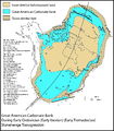
File:M98Ch2Fig1.JPG ...across Laurentia. Derby, James R., Robert J. Raine, Anthony C. Runkel, and M. Paul Smith, 2012, Paleogeography of the great American carbonate bank of L(800 × 915 (269 KB)) - 16:14, 19 August 2014- | author = John M. Armentrout ...w York, Springer-Verlag, p. 137–170.</ref><ref name=ch04r9>Armentrout, J., M., 1996, High-resolution sequence biostratigraphy: examples from the Gulf of8 KB (1,103 words) - 21:21, 23 February 2022
- | author = John M. Armentrout ...gin]] has been influenced by several factors:<ref name=ch04r26>Coleman, J. M., and H. H. Roberts, 1991, Mississippi River depositional system: model for3 KB (406 words) - 17:03, 22 February 2022
- | author = John M. Armentrout ...from the ''Glob alt'' sandstones and the ''Glob alt'' sandstone 200-ft (60-m) isopach.11 KB (1,482 words) - 15:47, 21 March 2022
- ....</ref><ref>Fulljames, J. R., L. J. J. Zijerveld, R. C. M. W. Franssen, G. M. Ingram, and P. D. Richard, 1996, Fault seal processes, in Norwegian Petrol3 KB (437 words) - 20:02, 13 December 2016
- ...e Formation''' is the Upper Lutetian central part of an approximately 3000 m thick package of Lutetian to Priabonian sediments in the Ainsa Basin<ref>Dr1 KB (163 words) - 00:12, 30 June 2014
- | author = Grant M. Skerlec ...tests, well [[stimulation]]s, and subsurface waste disposal.<ref>Evans, D. M., 1966, The Denver area earthquakes and the Rocky Mountain Arsenal disposal9 KB (1,274 words) - 15:44, 30 March 2022
- | author = John M. Armentrout ...ual Research conference, p. 142–145.</ref><ref name=ch04r10>Armentrout, J. M.,and J. F. Clement, 1990, Biostratigraphic calibration of depositional cyc9 KB (1,143 words) - 14:57, 23 February 2022
- | author = A. M. Sam Sarem ...ure number|3}}Vertical sweep efficiency (coverage) as a function of WOR, ''M'', and permeability variation (''V''<sub>DP</sub>), where WOR = 5.<ref name10 KB (1,468 words) - 18:23, 21 January 2022
- * ''R''<sub>m</sub> = 2.5 Ω-m at [[temperature::70°F]] * ''R''<sub>mf</sub> = 2.0 Ω-m at [[temperature::70°F]]13 KB (2,077 words) - 17:26, 18 January 2022
- | author = Grant M. Skerlec1 KB (179 words) - 20:54, 31 March 2022
- | author = John M. Armentrout ...c stratigraphy, Pliocene–Pleistocene, Gulf of Mexico, in Weimer, P., Link, M., H., eds., Seismic Facies and Sedimentary Processes of Submarine Fans and7 KB (895 words) - 16:18, 24 March 2022
- ...t prolific unconventional reservoirs outside of North America. At over 500 m thick with multiple stacked organic-rich intervals, the Vaca Muerta has gar ...highest potential for unconventional development<ref name=Zbrsk>Zborowski, M., 2018, [https://jpt.spe.org/how-does-vaca-muerta-stack-vs-us-shale-data-te11 KB (1,644 words) - 16:14, 11 May 2023
- | author = Grant M. Skerlec ...ction Research Company internal report.</ref><ref name=ch10r71>Skerlec, G. M., 1990, SEALS: A short course for risking top seal and fault seal: Franklin6 KB (930 words) - 15:49, 30 March 2022
- | author = John M. Armentrout ...w York, Springer-Verlag, p. 137–170.</ref><ref name=ch04r9>Armentrout, J., M., 1996, High-resolution sequence biostratigraphy: examples from the Gulf of7 KB (982 words) - 21:20, 23 February 2022
- ...</ref> quoted widths in excess of 40 km (25 mi) and thicknesses up to 1200 m (3937 ft) for the very large braided river systems (Table 1). These form in ...m (3-3937 ft); most < 60 m (197 ft); common range 5-60 m (16-197 ft) || 50 m-1300+ km (164 ft-808+ mi); many > 1 km (0.62 mi); common range 0.5-10 km (013 KB (1,859 words) - 21:29, 12 March 2019
- | author = John M. Armentrout ...within the same structure<ref name=ch04r86>Schanck, J. W., C. C. Cobb, and M. L. Ivey, Jr., 1988, East Breaks 160 field on the offshore Texas shelf edge10 KB (1,376 words) - 16:00, 23 March 2022
- ...500 m (5,000 ft), the thickness of the layer needs to be approximately 150 m (500 ft) or more. Low-resistivity layers are more easily delineated than hi3 KB (486 words) - 17:53, 25 January 2022
- | author = Grant M. Skerlec ...ediments near Lilstock, U.K., shows a gouge zone approximately [[length::5 m]] thick. The gouge consists predominantly of ductile shales and marls as we4 KB (509 words) - 16:52, 29 March 2022
- ...zy, M., B. Steer, F. Abu-Shadi, M. Schlorholtz, J. Mika, J. C. Dolson, and M. Zinger, 1996, Gulf of Suez rift basin sequence models--Part B: Miocene seq5 KB (746 words) - 16:54, 4 February 2022
- ...bb, A. Yin, T. M. Harrison, J. Célérier, G. E. Gehrels, C. E. Manning, and M. Grove, 2011, Cenozoic tectonic history of the Himachal Himalaya (northwest ...: Geology vol. 13.10, pp. 679-682.</ref><ref>Beaumont, C., R. A. Jamieson, M. H. Nguyen, and B. Lee, 2001, Himalayan tectonics explained by extrusion of10 KB (1,434 words) - 15:39, 20 January 2016
- ...field, southwestern U.S.A., in J. F. Read, L. J. Weber, J. F. Sarg, and F. M. Wright, eds., Milankovitch Sea-Level Changes, Cycles, and Reservoirs on Ca ...wedge trap: Lower Cretaceous Cutbank Sandstone, Montana, in J. C. Dolson, M. L. Hendricks, and W. A. Wescott, eds., Unconformity-Related Hydrocarbons i6 KB (862 words) - 15:20, 4 February 2022
- ..., such as Van Wagoner et al.<ref>Van Wagoner, J. C., H. W. Posamentier, R. M. Mitchum, P. R. Vail, J. F. Sarg, T. S. Loutit, and J. Hardenbohl, 1988, An4 KB (612 words) - 17:39, 13 April 2022
- | author = John M. Armentrout1 KB (176 words) - 17:29, 13 April 2022


