Contourites
| Wiki Write-Off Entry | |
|---|---|

| |
| Student Chapter | University of La Plata |
| Competition | June 2015 |
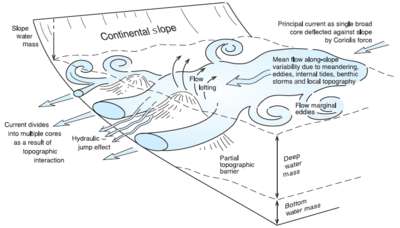
Contourites are oceanic sedimentary deposits originated by the circulation of thermohaline oceanic currents of contour, named this way because they follow bathymetric curves. These currents are caused by the global marine circulation and correspond to those of low temperature, which together warm temperature currents, conform a system of vital importance. These currents may flow upwards, downwards, around or above obstacles or irregular topographies.
In addition of taking part in the regulation of global temperatures and the distribution of the marine fauna, countour currents generate across-slope processes, that together with along-slope processes, dominate large part of the sedimentary dynamics in deep marine environments, either within the continenetal slope or the continental rise. Along-slope processes may generate drift or contouritic features. The latter are less known than the former, which are considered erosional terraces, contourite channels, abraded surfaces, moats and furrows (Hernandez-Molina et al.,2008).
Contourites, formed by oceanic currents which circulate along the continental slope, are often alterated by "turbiditic" sedimentary events. These turbiditic deposits are formed by gravitational processes at the seabed sharpest slopes, transverse to the continental slope. Sediment transport and the existence of fossils in said contournitic and turbidic sediments are traits that have implications in paleoclimatic, paleoceanographic aspects, as well as in the morphology of sediment within the oceanic margin, both kind of deposits are of critical importance as reservoirs of oil and other mineral resources.
History
The first person to mention abyssal deposits generated by sea bottom currents, was the german oceanographer Georg Wüst in 1930, however, it was not outstanding until 1964 when a student of his, Heezen and his supervisor Hollister introduced the concept of contourites. They pointed to the presence of sea bottom currents, which verified by measurements and photographs. Just in 1971, they define the term contourites when the real evidence of the existence and magnitude of the currents appear, when from photographs of various locations with traces of ripples caused by flowing contour, plus a wealth of information and evidence they could guide the interpretation of sediments collected at great ocean depths.
By the year 1976 at the School of Mines Geology from Caracas, Venezuela, the scientist Nicolás Muñoz applies the term “contornita”, in Spanish, as the equivalent of "contourite" but with a lithologic-petrographic order preceded by a descriptive name.
Formation
Bottom currents are responsible of contourites formation. They are affected by variations in temperatures, salinity, tides, waves, wind, topography and physical barriers that have to pass trough.
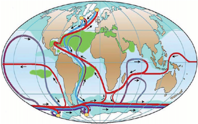
Thermohaline currents are the most common of type of bottom current, they conform the global conveyor belt (Figure 1). Its name derives from thermal= temperature and haline=salinity. Its relevance is in distributing the heat all over the world, from the tropics to Polar Regions. Changes on them could cause radical climate changes.
They begin on the Antarctic Ocean, most specifically in Weddell Sea. Considered as the coolest water, they separate from the salt faze, and sinking in the water mass, forming bottom currents. Flow eastward, affecting Pacific, Atlantic and Indian Oceans. From here temperature starts to rise as latitude decreases and bottom currents turn into shallow-water bottom currents. As this happens, it is enriched with salts and progressively increasing its temperature. Subsequently, a high evaporation cooling, where the concentrated salt water temperature drops, again becoming denser body will occur. This situation occurs in the seas of Greenland and Norway, here it returns to form deep undercurrents that flow south, to the west of the Atlantic Ocean.
Cold currents flow on the western edge of the ocean basins, therefore, on the eastern edge of the great land masses. While the warm currents, they will in the eastern margins of the ocean basins, or put another way, to the west of the land masses. The temperature gradient in the water, is most significant in the tropics, where surface water bodies, up to tens of meters, have more interaction with the climate and weather changes, presenting with an average temperature of 20 ° C. Beneath these waters, temperatures drop about 5 ° C, and greater depths the gradient is less evident and reaches be 4 ° C. At higher latitudes, depeest water bodies vary in a range from 0 to 2.2 ° C.
This process of global ocean circulation is affected by several factors:
- Winds: affect surface water, generate movement direction parallel to its direction due to the effect of shear, subsequent propagation and movement through the water column. The winds that affect the flow, are the Trade winds and the West.
- Coriolis Effect: diverts the winds, which are a meridional direction. Those that go to the poles, turning east, while those who turn to Ecuador, turn west.
- Also it affects ocean currents, causing them to have higher speeds on the western side of the ocean basins, of 10-20 cm / s; that unlike other they come to have a speed of 2 cm / s.
- Density influences the location of a body of water in the vertical. If it presents low density it will remain surface, while a high density will sink. In turn, this property is dependent on temperature and salinity.
- Salinity: High concentrations cause an increase in the density of water; while its low concentration, decrease it.
- Temperature: affects evaporation of water. At higher temperatures, the water evaporates and is concentrated in salts, increasing the density. At low temperatures, the water present lows salt concentration, therefore, is low density.
- In turn, the coldest waters are denser, and warmest waters, less dense, and tend to be on the surface.
- Landmasses: limited water currents, flowing perpendicular to them. The colder water flowing through the west side of the ocean, while warmer does the east side.
- Marine Topography affects and limits the movement of the currents.
In addition, some authors propose a minimum boundary depth of 300 meters. However, it has been found that is not entirely true, because some deposits can be shallow.
Contourite Facies and Features
Contourite deposits, also called drift, surface can range from small sizes (100km2) to giant (> 100,000 km2). A good example is the basin of Argentina that reaches cover an area 1,000,000km2. On average, its width, ranging from tens to hundreds of kilometers and its thickness from tens to 2000 meters. These can vary widely depending on factors such as sediment, stream velocity, availability of oxygen and others.
The lithology of these deposits does not differ much with respect to pelagic sediments and hemipelagic, it's commonly a mixed nature between terrigenous, biogenic, chemogenic and volcanigenic composition. Grain sizes are commonly fine size from silt and sand but also gravel size, and are considered a good to very good selection.
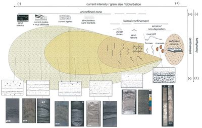
Tractive structures, product of the movement of bottom currents that form, are abundant and the most common are ripples currents and cross lamination. Some authors propose that flasser and lenticular-like structures characterized this type of deposit and different from others, as they reflect the variation in the intensity of the current, as well as the selection of grain selection (grading) and erosive scars also represent the same processes. Other common structures are horizontally or sinusoidal lamination, parallel lamination, crossbedding, pebblelags, etc. The preservation of these depends greatly on the degree of bioturbation that can reach delete left a massive structure.
Biogenic structures are usually diagnostic features of contourite deposits when conditions favor the benthic life and when the speed of the current cannot erase them. The mottling is the common structure sizes ranging from millimetric to centimetric but also usually appear ichnofacies like fodichnia, pascichnia and domichnia. The factor that primarily affects their absence or abundance is the oxygenation of the ocean floor. As for the fossil content, it depends on the parent material reworked, being common remains of planktonic animals.
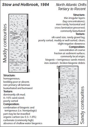
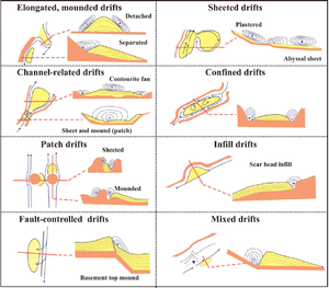
Gao et al. (1998) propose a facies classification based on grain size and the composition so there are muddy contourites, silty contourites, sandy contourites, gravel-lag contourites and bioclastic contourites, the first three with their calcareous variations (Figure 3). The most common in current deposits is muddy type, in which predominates the clay size with diffuse stratification and parallel lamination, bioturbation and organic traces. Among the most common fossils contourites, are sandy facies wich are well selected and stratified with gradations and bioturbation and organic traces can be abundant predominates. Another facies classification is proposed by Stow et al (1996). They propose that there clastic contourites (muddy, silty, sandy, gravel lag, micro-brecciated) biogenic (carbonate or siliceous) chemogenic and also the shallow water contourites. The depositional features can be classified into shallow (less than 300m), intermediate (between 300 and 2000 m) and deep drifts (more than 2000m). The most widely used classification (Rebesco, 2005) is based on its morphological, sedimentological and seismic characteristics shown in Figure 3.
Economic Significance
Recognition of the economic significance of contourites has only recently been pushed forward due to the continuous advance of hydrocarbon exploration.
The increasing use by academic institutions of high-resolution swath bathymetry and sea-floor imaging techniques, coupled correlating seismic anomalies from 3D mapping with core and well logging data reveals the depositional geometry and sedimentological characteristics of coarse-grained contourites.
Contourite deposits must present some particular characteristics. Coarse-grained sediments,preserving good petrophysical characteristics, such as porosity, permeability, and lateral and vertical transmissibility of fluids, must form part of the deposit, wich could be a great reservoir.
Fine-grained drifts can locally and regionally develop large and thick accumulations, which have an important seal potential for trapping hydrocarbon. The depth, thickness, extent and properties of these sands are determining.
Some reliable criteria for recognizing this, both in seismic profiles and lithology, need to be identified to predict their occurrence. Our findings could be an important change in future hydrocarbon exploration targets.
Bibliography
- Rebesco M. and A. Camerlenghi, 2008, Contourites: Elsevier Science
- Stow D. A. V., C. J. Pudsey J. A. Howe J.-C. Faugères and A. R. Viana, 2002, Deep-Water Contourite Systems: Modern Drifts and Ancient Series, Seismic and Sedimentary Characteristics: Geological Society Memoir 22
- Zabala C., 2004, “Cuso de campo sobre Sedimentología Descriptiva”.
- Rebesco M., A. Camerlenghi and A. J. Van Loon, 2008, “Contourite Research: A Field In Full Development, in: M. Rebesco & A. Camerlenghi, eds., Contourites: Developments in Sedmentology, 60, pp. 1-10
- Zenk, W., 2008, Abyssal and Contour Currents, in: M. Rebesco & A. Camerlenghi, eds., Contourites: Developments in Sedmentology 60, pp. 37-57
- Shanmugam G., “Deep-Water Bottom Currents And Their Ddeposits”
- Salon S., Crise A. and Van Loon A.J. “Dynamics Of The Bottom Boundary Layer”
- He Y., Duan T. and Gao Z., “Sediment Entrainment”
- Stow D.A.V., S. Hunter D. Wilkinson and F. J. Hernández-Molina, The Nature Of Contourite Deposition in: M. Rebesco & A. Camerlenghi, eds., Contourites: Developments in Sedmentology 60, pp. 143-156
- Faugeres J.-C. and Stow D.A.V. “Contourite Drifts: Nature, Evolution And Controls”
- Viana A. R., REBESCO M., 2007. "Economic and Palaeoceanographic Significance of Contourite Deposits"
