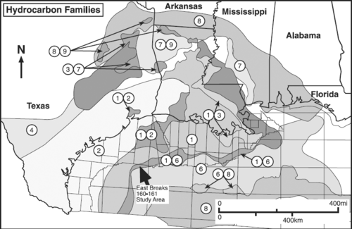
Maps of hydrocarbon types: Gulf of Mexico example
| Exploring for Oil and Gas Traps | |

| |
| Series | Treatise in Petroleum Geology |
|---|---|
| Part | Critical elements of the petroleum system |
| Chapter | Sedimentary basin analysis |
| Author | John M. Armentrout |
| Link | Web page |
| Store | AAPG Store |
Discussion
Hydrocarbon types reflect the composition of the kerogens from which they were generated. Kerogens are the insoluble organic matter in sedimentary rocks. Maps of hydrocarbon types estimate the number and distribution of mature generating source rocks. The map of hydrocarbon types in Figure 1 is based on analyses of more than 2000 oil, 600 gas, and 1200 seep samples correlated to specific source rocks. Nine oil-source-rock families have been identified (labeled 1-9; see Table 1), each having a specific geographic distribution related to mature source-rock location and migration paths. We will focus on the High Island-East Breaks area, where families 1 and 6 overlap (bold arrow).
Source table

Table 1, modified from Gross et al.[1] lists source-rock ages, oil types, and map numbers for Figure 1.
| Source-rock age | Oil type | Map # |
|---|---|---|
| Lower Tertiary (centered on Eocene, ~50-40 Ma) | ① ① ② | |
| Upper Cretaceous (centered on Turonian, ~85-95 Ma) |
|
③ ④ |
| Lower Cretaceous (centered on Aptian, ~115-105 Ma) |
|
⑤ ④ |
| Uppermost Jurassic (centered on Tithonian, ~140-130 Ma) |
|
⑥ ⑥ ⑥ ⑦ |
| Upper Jurassic (Oxfordian, ~ 152-145 Ma) |
|
⑧ |
| Triassic (Eagle Mills Formation, > 210 Ma) |
|
⑨ |
- ↑ 1.0 1.1 Tertiary marine and Tertiary intermediate are mapped together.
- ↑ 2.0 2.1 Calcareous; moderate sulfur; no Tertiary influence and Calcareous; moderate sulfur; Lower Cretaceous are mapped as an undifferentiated unit.
- ↑ 3.0 3.1 3.2 Oil subtypes related to variations in sulfur content and associated geochemical parameters have not been subdivided on Figure 1.
- ↑ Oil subtypes reflecting differences in salinity and clastic input to source facies are known but are not delineated on Figure 1.
Summary
By overlaying maps of total overburden thickness above major source-rock intervals, thermally mature source-rock distribution, hydrocarbon occurrences, and major structural features, the regional elements of the petroleum system(s) begin to emerge.
See also
- How to define the framework of a basin
- Example: defining a basin outline
- Example: mapping sediment thickness and field location