East Breaks reservoir rock
| Exploring for Oil and Gas Traps | |

| |
| Series | Treatise in Petroleum Geology |
|---|---|
| Part | Critical elements of the petroleum system |
| Chapter | Sedimentary basin analysis |
| Author | John M. Armentrout |
| Link | Web page |
| Store | AAPG Store |
Four reservoir intervals are productive in the East Breaks 160-161 minibasin: Glob alt, Glob M, Hyal B, and Trim A horizons. Reservoir intervals are named for the regionally useful bioevent species stratigraphically above the reservoir. These bioevents most often occur within condensed sections. All four reservoir intervals are interpreted to be gravity-flow sand deposits.[1] Only the Glob alt reservoir is considered here.
Glob alt sequence deposition
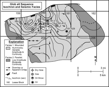
Figure 1 Map of the Glob alt depositional sequence of Late Pliocene age. After Armentrout et al.[2] Courtesy Springer-Verlag. Original map by Charles R. Beeman, Mobil Oil, 1987.
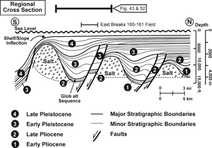
Figure 2 Schematic diagram of the seismic reflection profile along the west side of the East Breaks 160-161 field. From Armentrout & Clement;[3] Courtesy Gulf Coast SEPM.
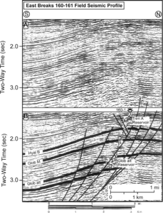
Figure 3 Seismic reflection profile showing the Glob alt reservoir interval. After Armentrout et al.[2] Courtesy Springer-Verlag.


The Glob alt depositional sequence of Late Pliocene age (mapped in Figure 1) is part of depositional cycle 2 in Figure 2. The sequence, deposited on a relatively open slope with only slightly undulating sea-floor topography, thins rapidly basinward due to sediment starvation in the most distal areas of the High Island-East Breaks depocenter (Figure 3). Subsequent progradation resulted in differential loading of the allochthonous salt and formation of local depocenters between downloaded growth fault sediment prisms and differentially displaced salt-cored anticlines.
Glob alt isochron and seismic facies map
Glob alt sandstones of the East Breaks 160-161 field occur within an isochron thick where hummocky seismic facies downlap toward and are buried by parallel low-amplitude seismic facies indicative of hemipelagic mudstone drape.[1] Figure 1 shows an isochron and seismic facies map of the Glob alt reservoir interval. The internal reflections of the mounded facies (1) downlap away from the isochron thick and toward the parallel seismic facies (2). Neither the isochron nor the seismic facies is mapped north of the fault due to poor data quality.
Seismic profile
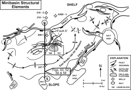
Figure 4 Structural elements that define the East Breaks 16-161 mini basin. From Armentrout et al.;[2] courtesy Springer-Verlag.
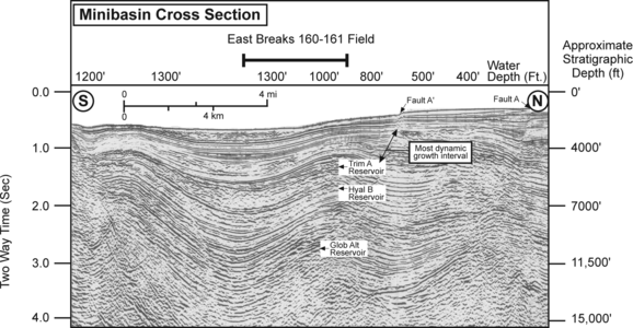
Figure 5 North-South seismic section through the East Breaks 160-161 field.


Figure 3 is a seismic reflection profile showing the Glob alt reservoir interval. Section A is uninterpreted; section B is interpreted. The reservoir thins southward between the top seal at the Glob alt condensed section datum and the underlying, unlabeled datum (thick black lines). The reservoir is penetrated by the 160-1 well in the faulted anticlinal trap formed by the rollover into the growth-fault complex bounding the north side of the mini basin (Figures 4, 5, and 2). The 160-1 electric log pattern is spontaneous potential.
Well-log cross section
Figure 6 is a well-log cross section of the Glob alt reservoir interval; datum is a mudstone within the GA-2 sandstone (well locations are shown on Figure 1). All logs are spontaneous potential with true vertical depth displays. The GA-4 reservoir sand is below the displayed interval. Log profiles are annotated: arrow C = funnel-shaped, coarsening-upward sandstone; arrow F = bell-shaped, fining-upward sandstone; parallel lines B = blocky profile of relatively thick sandstones and thin mudstone interbeds.
Net sandstone isopachs
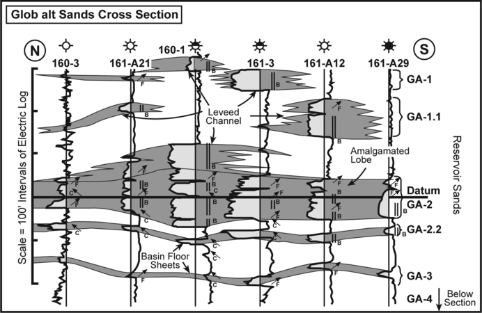
Figure 6 Well-log cross section of the Glob alt reservoir interval. After Armentrout et al.[2] Courtesy Springer-Verlag.
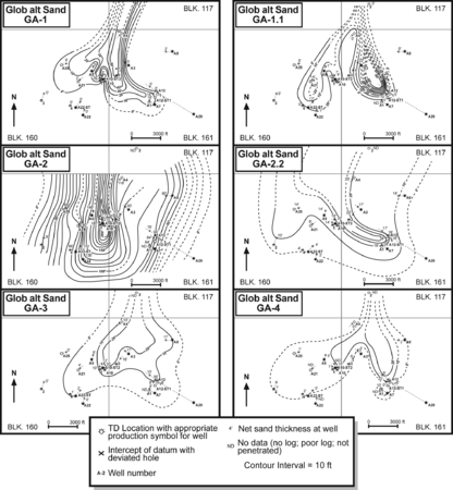
Figure 7 Net sandstone isopachs for reservoir units of the Glob alt sandstone interval. From Armentrout et al.[2]. Courtesy Springer-Verlag.


Well-log correlations within the Glob alt isochron thick show a succession of aggrading sandstone bodies (Figure 6). Figure 7 shows net sandstone isopachs for reservoir units of the Glob alt sandstone interval. The stratigraphic succession from top to bottom reservoir sandstone is 1, 1.1, 2, 2.2, 3, and 4. Maps of each sandstone interval document lobate deposition within the minibasin. Individual lobe development shows compensation lobe switching as progressively younger deposits infill the mud-rich/sand-poor intralobe areas of the preceding lobe.
The patterns mapped on the figure suggest lower thin lobate sheets (GA-4, GA-3, and GA-2.2), an intermediate thick lobe of amalgamated blocky sandstones (GA-2), and an upper moderately thick, bilobed leveed-channel system (GA-1.1 and GA-1). Net sandstone isopach contours are length::10 ft (3 m); the scale bar is depth::3000 ft (1000 m).
Depositional model summary
All the observations made from seismic profiles, isochron maps, seismic facies maps, well-log cross sections, cuttings, biofacies, and cores have been used to construct a depositional model for the Glob alt cycle of the High Island-East Breaks 160-161 minibasin. This model incorporates far-traveled gravity-flow sands that accumulated in a depositional thick, filling an upper-slope salt-withdrawal sea-floor low. Laterally shifting fan lobes resulted in a complex architectural framework (Figure 6). The profile pattern (Figure 3), combined with the mapped isochron and seismic facies pattern of Figure 1 and the net sandstone patterns of Figure 7, have been interpreted as minibasin basin-floor sheet sandstones, amalgamated-lobe sandstones, and leveed-channel sandstones by Armentrout et al.[1]) (see Figure 6).
Depositional model diagram
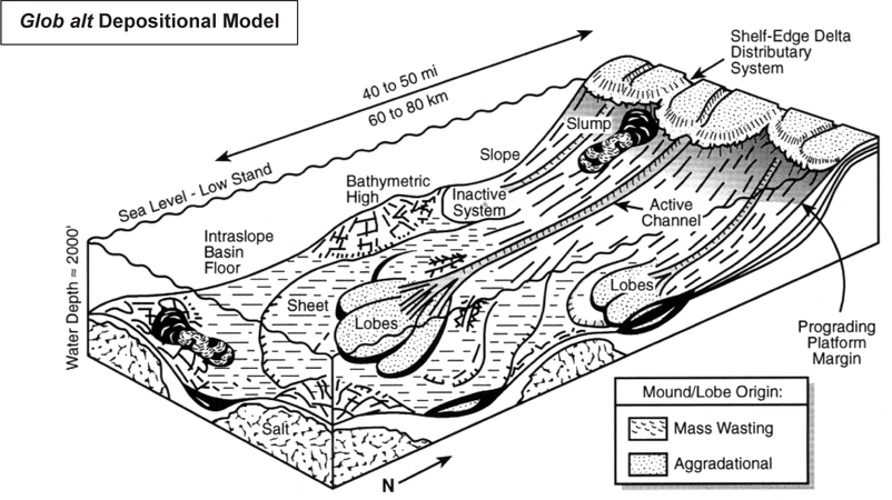
Figure 8 block diagram of the depositional model for the Glob alt reservoir interval. From Armentrout et al.[2]. Courtesy Springer-Verlag.
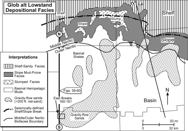
Figure 9 Depositional facies map for the Glob alt interval’s basal sequence boundary, constructed by integrating the biofacies map, the net sandstone map, and the seismic facies map. After Armentrout;[1] courtesy Springer-Verlag.


Figure 8 is a block diagram of the depositional model for the Glob alt reservoir interval. The model shows a 40-50-mi-long (60-80 km) transport system from a shelf-edge delta basinward to the East Breaks 160-161 minibasin. Depositional water depths exceeded depth::1000 ft (320 m) (upper bathyal), suggesting transport was by gravity-flow processes. Sandstone deposition in the minibasin may have resulted from subtle variations of sea-floor topography, perhaps related to early salt withdrawal.[4] Mass-wasting processes occurred on the slope well to the north of the field, as shown by slump facies on Figure 9. The areal extent of the basin-floor sheet is restricted by the areal extent of the East Breaks 160-161 intraslope minibasin.
Accommodation space

Differential loading of the mobile salt resulted in some syndepositional subsidence and accommodation of the Glob alt sand-prone isochron thick. The apparent thickening into the north-bounding growth fault is due to the maximum differential subsidence and isochron thickening being coincident with the fault trace of a much younger growth fault phase. Biostratigraphic calibration of the fault system indicates most, if not all, of the fault offset occurred during middle Pleistocene time, after the Trifarina rutila bioevent (= Ang B) dated at 1.30 Ma (Figure 10). This is more than length::1.5 m.y. after deposition of the Glob alt sands.
Structural trap formation
Structural trap formation is related to differential rotation of the Glob alt sand-prone interval. This rotation occurred between 1.3 Ma and the present. The result was the development of the rollover anticline downthrown to fault A′, which is a splay off regional fault A (Figures 4 and 5). (See Apps et al.,[6] Armentrout,[5] Kneller,[4] and Weimer and Bouma, 1995, for discussions on structural control of deepwater deposition.)
See also
- East Breaks petroleum system
- East Breaks seal rock
- East Breaks overburden rock
- East Breaks source rock
References
- ↑ 1.0 1.1 1.2 1.3 Armentrout, J. M., 1991, Paleontological constraints on depositional modeling: examples of integration of biostratigraphy and seismic stratigraphy, Pliocene–Pleistocene, Gulf of Mexico, in Weimer, P., Link, M., H., eds., Seismic Facies and Sedimentary Processes of Submarine Fans and Turbidite Systems: New York, Springer-Verlag, p. 137–170.
- ↑ 2.0 2.1 2.2 2.3 2.4 2.5 Armentrout, J. M., S. J. Malacek, P. Braithwaite, and C. R. Beeman, 1991, Seismic facies of slope basin turbidite reservoirs, East Breaks 160-161 field: Pliocene-Pleistocene, northwestern Gulf of Mexico, in P. Weimer and M. J. Link, eds., Seismic facies and sedimentary processes of submarine fans and turbidite systems: New York, Springer-Verlag, p. 223-239.
- ↑ Armentrout, J. M., and J. F. Clement, 1990, Biostratigraphic calibration of depositional cycles: a case study in High Island–Galveston–East Breaks areas, offshore Texas: Proceedings, Gulf Coast Section SEPM 11th Annual Research Conference, p. 21–51.
- ↑ 4.0 4.1 Kneller, B., 1995, Beyond the turbidite paradigm: Physical models for deposition of turbidites and their implications for reservoir prediction, in Hartley, A. J., and D. J. Prosser, eds., Characterization of Deep Marine Clastic Systems: Geological Society, London, Special Publication 94, p. 31–49.
- ↑ 5.0 5.1 Armentrout, J. M., 1996, High-resolution sequence biostratigraphy: examples from the Gulf of Mexico Plio–Pleistocene, in Howell, J., and J. Aiken, eds., High Resolution Sequence stratigraphy: Innovations and Applications: The Geological Society of London Special Publication 104, p. 65–86.
- ↑ Apps, G. M., F. J. Peel, C. J. Travis, and C. A. Yeilding, 1994, Structural controls on Tertiary deep water deposition in the northern Gulf of Mexico: Proceedings, Gulf Coast Section SEPM 15th Annual Research conference, p. 1–7.
External links
| find literature about East Breaks reservoir rock |