Difference between revisions of "File:M106Ch14Fig05.jpg"
(Schematic stratigraphy and source rock-reservoir-seal relationship for the Dezful embayment and neighboring areas. Main source rocks are indicated by green flags and marginal ones by white flags. Reservoirs (Res), seals, tectonic phases (Tect), and lat...) |
(No difference)
|
Latest revision as of 18:17, 12 July 2016
Schematic stratigraphy and source rock-reservoir-seal relationship for the Dezful embayment and neighboring areas. Main source rocks are indicated by green flags and marginal ones by white flags. Reservoirs (Res), seals, tectonic phases (Tect), and latitude at the time of deposition (Lat) are also indicated. Note that only the Neocomian part of the Garau Formation is organic-rich and acted as source rock. From M. L. Bordenave, 2014, Petroleum Systems and Distribution of the Oil and Gas Fields in the Iranian Part of the Tethyan Region, in L. Marlow, C. Kendall, and L. Yose, eds., Petroleum systems of the Tethyan region: AAPG Memoir 106, p. 505-540.
File history
Click on a date/time to view the file as it appeared at that time.
| Date/Time | Thumbnail | Dimensions | User | Comment | |
|---|---|---|---|---|---|
| current | 18:17, 12 July 2016 | 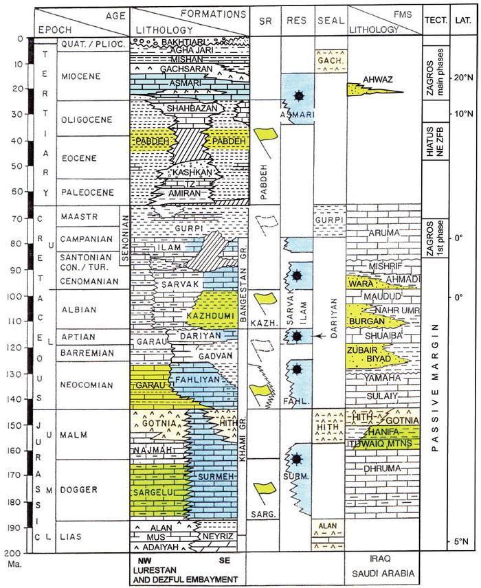 | 700 × 856 (149 KB) | Molyneux (talk | contribs) | Schematic stratigraphy and source rock-reservoir-seal relationship for the Dezful embayment and neighboring areas. Main source rocks are indicated by green flags and marginal ones by white flags. Reservoirs (Res), seals, tectonic phases (Tect), and lat... |
You cannot overwrite this file.
File usage
The following page uses this file: