Iran petroleum systems
| Petroleum systems of the Tethyan region | |
| |
| Series | AAPG Memoir |
|---|---|
| Chapter | Petroleum systems and distribution of the oil and gas fields in the Iranian part of the Tethyan Region |
| Author | M. L. Bordenave |
| Link | Web page |
| Store | AAPG Store |
A unique geological setting that included a long-lived shallow-water, often reefal, carbonate barrier along the edge of South Tethys and a nearly thousand kilometer wide back-barrier shallow-water Intracratonic Sea occurred during much of Mesozoic time in what is now southwest Iran. This barrier hampered water circulation between South Tethys and the Intracratonic Sea. This setting remained very sensitive to sea-level variations and climatic conditions and resulted in the accumulation of excellent source rocks in localized depressions when anoxic conditions prevailed.
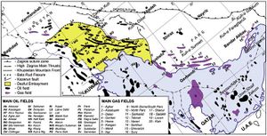
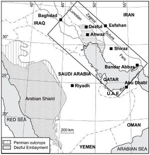
The area includes both the Iranian part of the Zagros foldbelt and its contiguous offshore. It extends over nearly 1400 km (875 mi) from the Iran-Iraq border in the northwest to the Zendan fault, East of Bandar Abbas, in the southeast. It is limited to the northeast by the Zagros suture. The area is slightly larger than 400,000 km2 (2,500,000 mi2); two-third of this area is located onshore (Figure 1). The Iranian Zagros foldbelt includes the three provinces of Lurestan, Khuzestan, and Fars. Lurestan and Fars are mountainous with deeply breached anticlines. Khuzestan is divided into two morphological zones: the mountainous Izeh zone to the north and the Dezful embayment to the south. These two zones are separated by the “Mountain Front” flexure (Figure 2), which seems to correspond to a basement thrust.[2] [3] [4]
The Dezful embayment covers only 60,000 km2 (37,500 mi2), but contains some 50 oil fields that account for more than 400 billion barrels of initial oil-in-place (IOIP), corresponding to 8% of the estimated global oil reserves. While Lurestan contains little reserves due to the poor quality of its reservoirs, Fars and its adjacent Iranian offshore contain some 650 TCF, corresponding to 12% of global gas reserves.
Petroleum systems[edit]
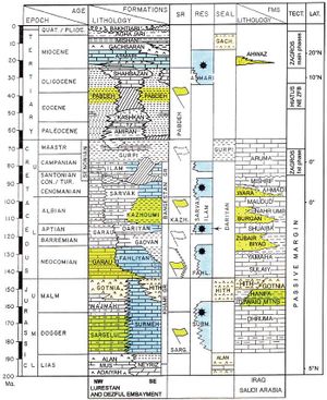
Five petroleum systems were defined based on the association of source rocks, reservoirs, and seals (Figure 3, Figure 4):
- The Paleozoic petroleum system: Early Silurian (Llandoverian) source rocks charged Permo-Triassic carbonates (Dalan and Kangan Formations) capped by the anhydrite of the Middle/Late Triassic Dashtak Formation, and locally a few younger reservoirs.
- The Middle Jurassic petroleum system: Sargelu source rocks deposited in the Mesopotamian depression are limited above and below by thick evaporitic series and are not connected to reservoirs, except at the edge of the depression.
- The Late Jurassic petroleum system: Hanifa–Tuwaiq Mountains/Diyab source rocks that extend on both sides of the Qatar Arch charged most of the giant oil fields in Abu Dhabi and Saudi Arabia. This system has an impact into the Iranian waters, where oil, often heavy, and bitumen are found in Early Cretaceous and younger reservoirs.
- The Early Cretaceous petroleum system: Source rocks deposited in the lower part of the Garau Formation during the Neocomian period extend in Lurestan in the Dezful embayment and in the northern part of the Gulf. These source rocks are limited below by thick evaporites (Gotnia) and above by thick basinal marls.
- The Middle Cretaceous to Early Miocene petroleum system: It includes two main source rocks, the Kazhdumi Formation of Albian age and the upper part of the Pabdeh Formation (Middle Eocene to Oligocene). A third source rock was developed locally and is known as the Ahmadi Member of the Sarvak Formation (Cenomanian) in Iran and as the Shilaif Formation in Abu Dhabi. These source rocks charged two reservoirs (Asmari and Sarvak). This system is capped by the evaporites of the Gachsaran Formation. Thin source rocks were also deposited during Cenomanian in a local intra-platform basin in Lurestan.[9] [10] [11]
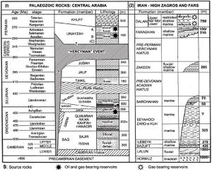
The Paleozoic petroleum system[edit]
The Paleozoic petroleum system provides an example of a complex system involving long range migrations from Llandoverian source rocks and the formation of large accumulations of oil and gas on regional highs occurring long before the formation of the Zagros folds, and the late re-accommodation of part of the gas in anticlines that resulted from the Late Miocene to Pliocene orogeny.[12]
The older sediments known in the Zagros foldbelt and offshore are the thick halite of the Hormuz Formation that formed early deep-seated salt-pillows and salt-plugs. These are overlain by Cambro-Ordovician fluviatile reddish cross-bedded sandstone and mud-stone, shallow marine shale and dolomite, generally organic-lean, which outcrop at the base of the High Zagros thrusts.[6] Ordovician sediments also outcrop at Kuh-e Surmeh in Central Fars (Figure 4).
The Middle Jurassic petroleum system[edit]
Sargelu source rocks were deposited during the Bajocian and Bathonian in the Mesopotamian depression. The Middle Jurassic petroleum system provides an example of source rocks that are poorly connected with reservoirs, excepting those located close to the edge of the depression.
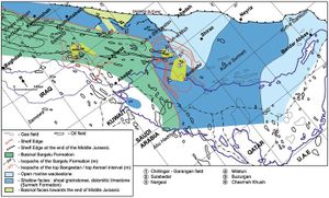
An elongated northwest-southeast carbonate shoal hampered the water circulation between the Epicontinental Sea and South Tethys during the Middle and Late Jurassic. The low-energy oxygen-deprived Sargelu facies was deposited in the subsiding Mesopotamian depression.[14] Thick evaporites accumulated during periods of sea level fall at the bottom of hypersaline waters, while anoxic episodes corresponded to high-stand periods. To the east of the depression, on a wide platform that covered Fars and the southeast part of the Dezful embayment, the depositional environment remained oxic and no source rocks were deposited (Figure 5).
The Sargelu Formation is composed of black finely laminated organic-rich shales and thin-bedded black bituminous limestone.[15] In Iraq, the Sargelu is conformably overlain by a condensed section of Late Jurassic age, which is highly bituminous (Naokelekan Formation). In Lurestan, the Sargelu Formation is 100–300 m (328.1–984.2 ft) thick. It is thinner in the central part of the depression, indicating a starved basin; that is, the supply of fine-grained sediments, originating from the distant Arabian shield, was not sufficient to match the subsidence.
Samples from Kuh-e Bangestan-1 and Samand-1 were analyzed. At Samand, where the Sargelu is overmature (Tmax between 462 and 476°C), the residual TOC varies from 1.2 to 3.0%. At Kuh-e Bangestan, where the oil window was reached (Tmax 443°C), current TOC varies between 3.1 and 4.4%, and current HI varies from 190 to 260 g HC/kg C. The isotopic composition (d13C) of the Sargelu pyrolysate was comprised between −29.2 and −28.2. Fields located in Iraq, close to the Iran–Iraq border (Buzurgan and Jebel Fauqi) were charged by Sargelu source rocks, as their oil composition is compatible with the Sargelu pyrolysate. They contain Gammacerane, testifying to the hypersalinity of the Mesopotamian depression during the Middle/Late Jurassic.[16]
The Late Jurassic petroleum system in Iran[edit]
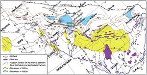
During the Late Callovian, Oxfordian, and Early Kimmeridgian, anoxic conditions prevailed in two intrashelf depressions that extended on both sides of the Qatar Arch. Excellent source rocks were deposited in the Hanifa–Tuwaiq Mountain Formations of Saudi Arabia, west of Qatar and the northern part of the Arabo-Persian Gulf, and in the time-equivalent Diyab Formation in Abu Dhabi. These source rocks are connected with the excellent reservoirs of the Arab Formation, which is sealed by the Hith Anhydrite.[17] [18] [19] The western depression communicated with the Mesopotamian Basin where the condensed organic-rich Naokelekan Formation and the basinal evaporites of the Gotnia Formations accumulated during the Late Jurassic.
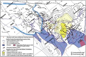
The kitchens of the Hanifa–Tuwaiq Mountain and Diyab source rocks are located outside of Iran (Figure 6). However, some oil migrated over a long distance toward the Gavbendi and the South Bushehr regional highs. Heavy oil and bitumen remain trapped in various reservoirs of salt-related domes, in the absence of efficient seals at the time of migration.
In the Abu Dhabi waters west of Zakum, the basal part of the Diyab Formation consists of 45–85 m (148–279 ft) of thick, laminated, organic-rich, and radioactive calcareous shales and argillaceous limestone. East of Zakum, the Diyab Formation passes into a clean sucrosic dolomitic facies (Figure 6). Actual TOC values of the Diyab Formation vary between 0.3 and 5.5%, with most of the values being lower than 2%. The Diyab Formation being already mature (Ro varying from 0.8% at Salman to 1.7% at Bu Hasa), the initial TOC values were probably 1.5 times to twice the present values.[23] [24] At the offshore ADNOC-1b well, located south of Nasr, oil expulsion from the Diyab source rock likely began toward the end of the Eocene.[25]
West of Qatar, up to 150 m (492 ft) of organic-rich and radioactive laminated calcareous shales and argillaceous limestone were deposited in the Hanifa and Tuwaiq Mountain Formations. TOC values are generally lower than 7.5%, with an average value of 3%. The Rock Eval S2 peak would categorize the kerogen as a rich type 2, with S2 generally consisting of 5–40 g HC/kg Rock (average 25 g HC/kg Rock), and Hydrogen Index (HI) values varying from 600 to 800 g HC/kg C. The carbon isotopic composition of the source rock samples varies from −27.5 to −26 PDB (average −26.4) for the kerogen, and from −28 to −26, (average −26.6) for the extracted bitumen. These values are compatible with the carbon isotopic composition of oils found in the Jurassic reservoirs of Saudi Arabia.[22] Modeling applied to the Hanifa source rocks from Ghawar to Safaniya and Bahrain shows that oil expulsion began 75 Ma ago at the beginning of the Maastrichtian, while the peak of oil generation was reached by the Middle Eocene (50 Ma). However, oil generation continued up to the beginning of the Miocene.[26] [22]
The Early Cretaceous petroleum system[edit]
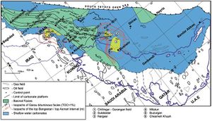
Excellent source rocks deposited in the lowermost part of the Garau Formation during the Neocomian are widely distributed throughout a depression including Lurestan and the Dezful Embayment (Figure 7). Similar to the Sargelu Formation, Garau source rocks are unconnected or poorly connected to reservoirs, at least in the central part of this depression.
In the central part of the Lurestan depression, the first reservoirs that could have drained the source rocks were either the high-energy limestones in the Sarvak Formation in the southern part of the depression or the Ilam limestone.[9] [27][10] In the absence of a reservoir directly associated with the Garau source rocks, a good part of the oil was likely cracked in situ, causing the formation of pyrobitumen and gas. Some oil was expelled through a network of linear microfaults and formed impressive dykes, sometimes up to 20 cm thick, of gillsonite-type material observed in several Lurestan breached anticlines, particularly on the northeast flank of Kuh-e Sultan.[9]
In the Dezful embayment, the 15–25 m (49.2–82 ft) thick shallow-water limestone of the Khalij Member of the Gadvan Formation facilitated the migration of some oil/gas toward the platform facies of the Khami Group, and its accumulation on pre-Zagros Highs (Figure 8), where reservoirs of the Khami Group are efficiently sealed by the organic-rich Kazhdumi Formation.
The Middle Cretaceous to Early Miocene petroleum system[edit]
The Middle Cretaceous to Early Miocene petroleum system provides a completely different setting based upon vertical migration, enhanced by fracturing, toward large Zagros anticlinal structures. Such a setting implies excellent correlation between the composition of source rock pyrolysates and oils from current accumulations, in terms of isotopic composition (δ13C, δ34S) and biomarker composition.[28] In such a setting, a theoretical amount of oil generated and expelled by source rocks in the drainage area of anticlines could be calculated by modeling, and compared to the IOIP of the corresponding fields.
About 8% of the global oil reserves concentrated in the 60,000 km2 Dezful embayment accumulated in two limestone reservoirs; the Asmari limestone, associated in the southwest part of the Dezful embayment with sands (Ahwaz Member), contains 75% of the IOIP, and the Bangestan Group (Sarvak and Ilam Formations) contains another 23%. Seven of the largest fields listed in Table 1 are grouped in an area extending over only 12,000 km2.
| Main oil fields (IOIP >109 barrels) | Discovery year | IOIP (109 barrels) + IGIP (TCF | Current production (b/d) |
|---|---|---|---|
| Ahwaz | 1958 | 56 + 25 A+B | 600,000 (2005) |
| Gachsaran | 1928 | 53 + 34 A/B | 490,000 (2006) |
| Marum | 1963 | 46 + 67 A/B | 520,000 (2006) |
| Agha Jari | 1932 | 26 + 25 A/B | 200,000 (2000) |
| Mansuri | 1963 | 20 + 7 A+B | 100,000 (2008) |
| Rag-e Safid | 1964 | 16 + 27 A/B | 160,000 (2008) |
| Bibi Hakimeh | 1961 | 15 + 12 A/B | 114,000 (2006) |
| Azadegan | 1999 | 26 + ? I+Zs | 30,000 (2009) |
| Aboozar | 1959 | G/A + Khami | 127,000 (2008) |
| Main gas fields (IGIP >10 TCF) | |||
| Pazanan | 1932 | 6 + 45 A/B | |
| South Pars | 1975 | 436 TCF DK | |
| North Pars | 1965 | 60 TCF DK | |
| Kish | 2005 | 36 TCF DK | |
| Kangan | 1973 | 20 + TCF DK | |
| Tabnak | 2001 | 15 TCF DK | |
| (IOIP and IGIP for the Dezful Embayment fields from Oil Service Company of Iran reports (1979) and recent National Iranian Oil Company press releases); A/B Asmari and Bangestan (Sarvak and Ilam) connected limestone reservoirs; A+B Asmari and Bangestan separated reservoirs; G/A Asmari limestone and Ghar sands; I_Zs Ilam limestone and Zubair sands; DK Dalan and Kangan limestone and dolomite | |||
In most of the Dezful embayment’s main fields, located in high-relief asymmetric, often thrusted, anticlines, reservoirs of the Asmari and Sarvak Formations are interconnected and have the same oil-water level (OWL) as a result of the intense fracturing of the Pabdeh-Gurpi marls in the crestal part of the reservoirs. By contrast, the Asmari, Ilam, and Sarvak Formations form distinct reservoirs in lower-relief anticlines, such as Mansuri. The Asmari reservoir is covered by the thick evaporites (halite and anhydrite) of Gachsaran Formation. The oil currently trapped in the Asmari and Bangestan reservoirs originated from two main source rocks, the Kazhdumi Formation of Albian age, and the Pabdeh Formation (Middle Eocene and Early Oligocene). Limited amounts of oil came from the Ahmadi Member of the Sarvak Formation (Early Cenomanian).
See also[edit]
- Phanerozoic Tethys region
- Iraq petroleum geology
- Israel petroleum systems
- Libya hydrocarbon provinces
- Tethys region
- Petroleum basins of Turkey
- Jordan petroleum geology
References[edit]
- ↑ Sherkati, S. and Letouzey, J., 2004, Variation of structural style and basin evolution in the Central Zagros (Izeh zone and Dezful embayment), Iran: Marine and Petroleum Geology, v. 21, p. 535-554.
- ↑ Sherkati, S., Molinaro, M., Frizon De Lamotte, D., and Letouzey, J., 2005, Detachment folding in the Central and Eastern fold-belt (Iran): Salt mobility, multiple detachment and late basement control: Journal of Structural Geology, v. 27, p. 1680–1696.
- ↑ Emami, H., Verges, J., Nalpas, T., Gillespie, P., Sharp, I., Karpuz, R., Blanc, E. P., and Goodarzi, M. G. H., 2010, Structure of the Mountain Front flexure (NW Zagros, Iran): Insights from sand box model, in P. Leturmy and C. Robin, eds., Tectonic and stratigraphic evolution of Zagros and Makran during the Mesozoic and Cenozoic: Geological Society of London Special Publication 330, p. 155–178.
- ↑ McGillivray, J. G. and Husseini, M. I., 1992, The Paleozoic petroleum geology of Central Arabia: AAPG Bulletin, v. 76, no. 10, p. 1473–1490.
- ↑ 6.0 6.1 Setudehnia, A., 1976, The Paleozoic Sequence at Zard-e Kuh and Kuh-e Dinar: Bulletin Iran Petroleum Institute, v. 60, p.16–33.
- ↑ Huber, H., 1978, Geological map of Iran, 1:1,000,000 with explanatory note: National Iranian Oil Company, Exploration and Production Affairs, Tehran.
- ↑ Ghavidel-Syooki, M., 2003, Palyno-stratigraphy of Devonian sediments in the Zagros Basin, Southern Iran: Review of Paleobotany and Palynology, v. 127, p. 241–268.
- ↑ 10.0 10.1 Sharp, I. R., Gillespie, P., Morsalnezadeh, D., Taberner, C., Karpuz, R., Verges, J., Horbury, A., Pickard, N., Garland, J., and Hunt, D., 2010, Stratigraphic architecture and fracture-controlled dolomitization of the Cretaceous Khami and Bangestan Group: An outcrop case study, Zagros Mountain, Iran, in F. S. P. Van Buchem, K. D. Gerdes, and M. Esteban, Mesozoic and Cenozoic carbonate systems of the Mediterranean and the Middle East: Geological Society of London Special Publication 329, p. 343–396.
- ↑ Van Buchem, F. S. P., Allan, T. L., Laursen, G. V., Lotfpour, M., Moallemi, A., Monibi, S., Pickard, N. A. H., Tahmasbi, A. R., Vedrenne, V., and Vincent, B., 2010, Regional stratigraphic architecture and reservoir types of the Oligo-Miocene deposits in the Dezful embayment (Asmari and Pabdeh Formations) SW Iran, in F. S. P. Van Buchem, K. D. Gerdes, and M. Esteban, eds., Mesozoic and Cenozoic carbonate systems of the Mediterranean and the Middle East, Geological Society of London Special Publication 329, p. 219–253.
- ↑ James, G. A., and Wynd, J. G., 1965, Stratigraphic nomenclature of Iranian Oil Consortium Agreement Area: AAPG Bulletin, v. 49, no. 12, p. 2182–2245.
- ↑ Dunnington, H. V., Van Bellen, R. C., Wetzel, R., and Morton, D. M., 1959, Léxique Stratigraphique International, Iraq: vol. III, L. Dubertret, ed., CNRS, Paris, fasc. 10a, 333 p.
- ↑ Connan, J. and Deschesne, O., 1996, Le bitume à Suse, collection du musée du Louvre: Edition de la Réunion des Musées Nationaux, Paris, 444 p.
- ↑ Murris, R. J., 1980, Middle East stratigraphic evolution and oil habitat: AAPG Bulletin, v. 64, p. 587–618.
- ↑ Sharland, P. R., Archer, R., Casey, D. M., Davies, R. B., Hall, S. H., Heward, A. P., Horbury, A. D., and Simmons, M. D., 2001, Arabian plate sequence stratigraphy: Special Publication 2, GeoArabia, Gulf PetroLink, Bahrain, 371 p.
- ↑ Ziegler, M., 2001, Late Permian to Holocene Paleofacies evolution of the Arabian plate and its hydrocarbon occurrences, GeoArabia, v. 6, no. 3, p. 445–504.
- ↑ Ayres, M. G., M. Bilal, R. W. Jones, L. W. Slentz, M. Tartir, and A. O. Wilson, 1982, Hydrocarbon habitat in main producing areas, Saudi Arabia: AAPG Bulletin, v. 66, no. 1, p. 109.
- ↑ Loutfi, G. and El-Bishlawy, S., 1986, Habitat of hydrocarbon in Abu Dhabi, UAE: Symposium on hydrocarbon potential of intense thrust zones: Abu Dhabi, December 1986, p. 63–124.
- ↑ 22.0 22.1 22.2 Carrigan, W. J., Jones, P. J., Tobey, M. H., Alpern, H. I., Wender, L. E., Philp, R. P., and J. Allen, 1998, Geochemical variations among eastern Saudi Arabian Paleozoic condensates related to different source kitchens areas: Organic Geochemistry, v. 29, no. 1-3, p. 785–798.
- ↑ Hassan, T. H. and Azer. S., 1985, The occurrence and origin of oil in offshore Abu Dhabi: S.P.E. Middle East Technical Conference and Exhibition, Bahrain. p. 143–160.
- ↑ Alsharhan, A. S., 1989, Petroleum geology of the United Arab Emirates: Journal of Petroleum Geology, v. 12, no. 3, p. 253–288.
- ↑ Gumati, Y. D., 1993, Kinetic Modeling, Thermal maturation and hydrocarbon generation in the United Arab Emirates: Marine and Petroleum Geology, v. 10, p. 153–161.
- ↑ Chaube, A. N. and Al Samahiji, J., 1994, Jurassic and Cretaceous of Bahrain: Geology and petroleum habitat, Geo 94, Gulf PetroLink, Manama, Bahrain, p. 292–305.
- ↑ Razin, P., Taati, F. and Van Buchem, F. S. P., 2010, Sequence stratigraphy of Cenomanian-Turonian carbonate platform margins (Sarvak Formation) in the High Zagros, SW Iran: An outcrop reference model for the Arabian plate, in F. S. P. Van Buchem, K. D. Gerdes, and M. Esteban, eds., Mesozoic and Cenozoic Carbonate systems of the Mediterranean and the Middle East, Geological Society of London Special Publication 329, p. 187–218.
