Difference between revisions of "File:M106Ch14Fig14.jpg"
Jump to navigation
Jump to search
(Isopachs of the source rocks developed in the lower part of the Garau Formation (after Bordenave and Huc, 1995). Regional highs close to the Mesopotamian depression area are also indicated. 100 km (62.1 mi). From M. L. Bordenave, 2014, Petroleum System...) |
(No difference)
|
Latest revision as of 19:35, 12 July 2016
Isopachs of the source rocks developed in the lower part of the Garau Formation (after Bordenave and Huc, 1995). Regional highs close to the Mesopotamian depression area are also indicated. 100 km (62.1 mi). From M. L. Bordenave, 2014, Petroleum Systems and Distribution of the Oil and Gas Fields in the Iranian Part of the Tethyan Region, in L. Marlow, C. Kendall, and L. Yose, eds., Petroleum systems of the Tethyan region: AAPG Memoir 106, p. 505-540.
File history
Click on a date/time to view the file as it appeared at that time.
| Date/Time | Thumbnail | Dimensions | User | Comment | |
|---|---|---|---|---|---|
| current | 19:35, 12 July 2016 | 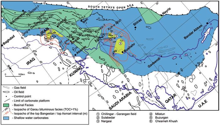 | 700 × 402 (73 KB) | Molyneux (talk | contribs) | Isopachs of the source rocks developed in the lower part of the Garau Formation (after Bordenave and Huc, 1995). Regional highs close to the Mesopotamian depression area are also indicated. 100 km (62.1 mi). From M. L. Bordenave, 2014, Petroleum System... |
You cannot overwrite this file.
File usage
The following page uses this file: