Difference between revisions of "Offshore exploration and exploitation"
Cwhitehurst (talk | contribs) |
Cwhitehurst (talk | contribs) |
||
| (7 intermediate revisions by the same user not shown) | |||
| Line 7: | Line 7: | ||
==Exploration== | ==Exploration== | ||
| + | Exploration first consists of the indirect searching for the resources using geophysical methods: Magnetic survey or register, gravimetric survey, and seismic survey. | ||
| − | |||
| − | |||
| − | |||
=== Magnetic survey or register === | === Magnetic survey or register === | ||
Consist in the register of the magnetic fields of the rocks, having the Earth magnetic field as reference. These fields are registered by a magnetometer installed in a plane that flies over the interest zone. Sedimentary formations with hydrocarbons don't manifest [[magnetics]] properties. | Consist in the register of the magnetic fields of the rocks, having the Earth magnetic field as reference. These fields are registered by a magnetometer installed in a plane that flies over the interest zone. Sedimentary formations with hydrocarbons don't manifest [[magnetics]] properties. | ||
=== Gravimetric survey === | === Gravimetric survey === | ||
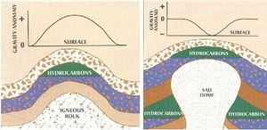
| − | + | [[File:Figura 1.jpeg|300px|thumbnail|right|{{figure number|1}}Gravimetric survey]] | |
| − | |||
| − | |||
| − | |||
| − | [[File: | + | Registers the variation of rock density, taking as reference the Earth gravitational field ([[:File:Figura 1.jpeg|Figure 1]). |
| − | === | + | ===Seismic survey=== |
| − | + | Seismic surveys are the most used and complete method of all. Register the reflection and refraction variation of induced waves into the surface, where the different formations will act in opposite ways, according their characteristics. These waves are captured in surface or, in the offshore exploration, in a ship, by seismographers, who gauge the transit time and the intensity of the reflected waves for the subgrade rocks. There are three kinds of seismic models: one more complete and detail than the other one: 2-D, 3-D, and 4-D seismic. | |
| − | [[File: | + | ====2-D Seismic==== |
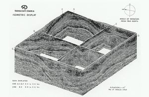
| + | [[File:2D Seismic.jpeg|300px|thumbnail|right|{{figure number|2}}2-D Seismic]] | ||
| + | In two dimensions ([[:File:2D Seismic.jpeg|Figure 2]]), the sources and receptors of the induced waves are ubicated in a line, as a result the seismic line covers the structure. The separation of these lines are ubicated according to the objective and detail level. | ||
| − | ==== | + | ==== 3-D Seismic ==== |
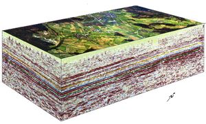
| − | + | [[File:3D Seismic.jpeg|300px|thumbnail|left|{{figure number|3}}3-D Seismic]] | |
| − | + | Surveying in three dimensions ([[:File:3D Seismic.jpeg|Figure 3]]), registers the sources and receptors ubicates across perpendicular lines in each interest area, which results in a seismic data volume, with bigger density than r2-D seismic, and provides better ubication of the structures. This method generates seismic cubes according to the depth and length of the seismic line and the width of the hydrophones arrangement. | |
| − | ==== | + | |
| − | + | ====4-D Seismic==== | |
| − | Once that the seismic shows successful results, is necessary bring | + | 4-D seismic consists of the repetition of a 3-D seismic survey in exactly the same original area, after a determined time. In consequence, the time function is added to a 3-D cube. Once that the seismic shows successful results, it is necessary bring an ocean bed survey to look at topography, in an area of 30 km<sup>2</sup>, having as objective establish the substrate conditions for the anchorage or support of the perforation unit. This is realized by bathymetry and cursory seismic. There must also be a wind, current, and wave study. |
==Exploitation Instance== | ==Exploitation Instance== | ||
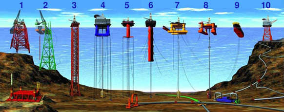
| + | [[File:Different kinds of platforms.png|framed|{{figure number|4}}Different kinds of platforms: 1, 2) conventional fixed platforms; 3) compliant tower; 4, 5) vertically moored tension leg and mini-tension leg platform; 6) spar; 7, 8) semi-submersibles; 9) floating production, storage, and offloading facility; 10) sub-sea completion and tie-back to host facility. Courtesy Ocean Explorer<ref>[https://oceanexplorer.noaa.gov/explorations/06mexico/background/oil/media/types_600.html Ocean Explorer]</ref>]] | ||
| − | [[File:Different kinds of platforms.png | + | After a successful exploration, next comes the offshore platforms installation. These platforms extract oil and gas, and are used as a home for the workers and communication towers. Depending the circumstances, the platform can be fixed at the seafloor, float, or be an artificial island. There different kinds of platforms ([[:File:Different kinds of platforms.png|Figure 4]]), each one with different especial characteristic according to the deposit and ocean bed kind. |
| − | + | ==References== | |
| + | {{reflist}} | ||
==Bibliography== | ==Bibliography== | ||
| − | + | * Michaud, F., and G. Ratzoud, G., et al., 2005, Métodos e Instrumentación acústica para la exploración en Geofísica Marina. | |
| − | * Michaud, F., Ratzoud, G., et al. Métodos e Instrumentación acústica para la exploración en Geofísica Marina | + | * Alvarez, C., and C. Lupo, 2014, [http://oilproduction.net/perforacion/item/1803-evaluacion-de-localizaciones-para-la-perforacion-costa-afuera Evaluación de Localizaciones para la perforación costa afuera]: Sclumberger. |
| − | * Alvarez, C., Lupo, | + | * Garcia Arboix, N., and J. A. Roca Maideu, Investigación de los materiales de una plataforma offshore: Universitat Politecnica de Catalunya Barcelonatech. |
| − | * Garcia Arboix, N., | ||
==External Links== | ==External Links== | ||
| − | |||
* http://oceanexplorer.noaa.gov/explorations/06mexico/background/oil/media/types_600.html | * http://oceanexplorer.noaa.gov/explorations/06mexico/background/oil/media/types_600.html | ||
Latest revision as of 22:00, 10 April 2019
| Wiki Write-Off Entry | |
|---|---|

| |
| Student Chapter | UNLP: La Plata |
| Competition | June 2015 |
Offshore drilling is the searching for hydrocarbon resources off of the continental platform. The exploration and exploitation are complex because of the difficulty for the transport of the necessary machinery. As a first step, it is necessary make indirect exploration, which, if it is successful, goes to a direct exploration, and if that is also successful, ends finally in an exploitation.
Exploration
Exploration first consists of the indirect searching for the resources using geophysical methods: Magnetic survey or register, gravimetric survey, and seismic survey.
Magnetic survey or register
Consist in the register of the magnetic fields of the rocks, having the Earth magnetic field as reference. These fields are registered by a magnetometer installed in a plane that flies over the interest zone. Sedimentary formations with hydrocarbons don't manifest magnetics properties.
Gravimetric survey
Registers the variation of rock density, taking as reference the Earth gravitational field ([[:File:Figura 1.jpeg|Figure 1]).
Seismic survey
Seismic surveys are the most used and complete method of all. Register the reflection and refraction variation of induced waves into the surface, where the different formations will act in opposite ways, according their characteristics. These waves are captured in surface or, in the offshore exploration, in a ship, by seismographers, who gauge the transit time and the intensity of the reflected waves for the subgrade rocks. There are three kinds of seismic models: one more complete and detail than the other one: 2-D, 3-D, and 4-D seismic.
2-D Seismic
In two dimensions (Figure 2), the sources and receptors of the induced waves are ubicated in a line, as a result the seismic line covers the structure. The separation of these lines are ubicated according to the objective and detail level.
3-D Seismic
Surveying in three dimensions (Figure 3), registers the sources and receptors ubicates across perpendicular lines in each interest area, which results in a seismic data volume, with bigger density than r2-D seismic, and provides better ubication of the structures. This method generates seismic cubes according to the depth and length of the seismic line and the width of the hydrophones arrangement.
4-D Seismic
4-D seismic consists of the repetition of a 3-D seismic survey in exactly the same original area, after a determined time. In consequence, the time function is added to a 3-D cube. Once that the seismic shows successful results, it is necessary bring an ocean bed survey to look at topography, in an area of 30 km2, having as objective establish the substrate conditions for the anchorage or support of the perforation unit. This is realized by bathymetry and cursory seismic. There must also be a wind, current, and wave study.
Exploitation Instance

After a successful exploration, next comes the offshore platforms installation. These platforms extract oil and gas, and are used as a home for the workers and communication towers. Depending the circumstances, the platform can be fixed at the seafloor, float, or be an artificial island. There different kinds of platforms (Figure 4), each one with different especial characteristic according to the deposit and ocean bed kind.
References
Bibliography
- Michaud, F., and G. Ratzoud, G., et al., 2005, Métodos e Instrumentación acústica para la exploración en Geofísica Marina.
- Alvarez, C., and C. Lupo, 2014, Evaluación de Localizaciones para la perforación costa afuera: Sclumberger.
- Garcia Arboix, N., and J. A. Roca Maideu, Investigación de los materiales de una plataforma offshore: Universitat Politecnica de Catalunya Barcelonatech.


