Difference between revisions of "Magnetotellurics case history: Precambrian overthrust (Northwestern Colorado)"
FWhitehurst (talk | contribs) |
Cwhitehurst (talk | contribs) m (added Category:Treatise Handbook 3 using HotCat) |
||
| (3 intermediate revisions by 2 users not shown) | |||
| Line 6: | Line 6: | ||
| part = Predicting the occurrence of oil and gas traps | | part = Predicting the occurrence of oil and gas traps | ||
| chapter = Applying magnetotellurics | | chapter = Applying magnetotellurics | ||
| − | | frompg = 16- | + | | frompg = 16-10 |
| − | | topg = 16- | + | | topg = 16-10 |
| author = Arnie Ostrander | | author = Arnie Ostrander | ||
| link = http://archives.datapages.com/data/specpubs/beaumont/ch16/ch16.htm | | link = http://archives.datapages.com/data/specpubs/beaumont/ch16/ch16.htm | ||
| Line 14: | Line 14: | ||
| isbn = 0-89181-602-X | | isbn = 0-89181-602-X | ||
}} | }} | ||
| − | Magnetotellurics (MT) can be used in an [[overthrust]] environment to delineate conductive sediments beneath a resistive thrust plate. It is often difficult to acquire good-quality [[seismic data]] in an overthrust area where high-velocity (high-resistivity, low-conductivity) rocks overlie low-velocity (low-resistivity, high-conductivity) sediments. | + | Magnetotellurics (MT) can be used in an [[overthrust]] environment to delineate [[Wikipedia:Electrical resistivity and conductivity|conductive]] sediments beneath a [[Wikipedia:Electrical resistivity and conductivity|resistive]] thrust plate. It is often difficult to acquire good-quality [[seismic data]] in an overthrust area where high-velocity (high-resistivity, low-conductivity) rocks overlie low-velocity (low-resistivity, high-conductivity) sediments. |
The [[Precambrian]] overthrust in the Bear Springs area of northwestern Colorado is an example.<ref name=ch16r5>Mills, A., 1994, Zephyr Geophysical Services, personal communication.</ref> | The [[Precambrian]] overthrust in the Bear Springs area of northwestern Colorado is an example.<ref name=ch16r5>Mills, A., 1994, Zephyr Geophysical Services, personal communication.</ref> | ||
| Line 32: | Line 32: | ||
* Thickness of Precambrian thrust sheet | * Thickness of Precambrian thrust sheet | ||
* Thinning of Cretaceous sediments to the south | * Thinning of Cretaceous sediments to the south | ||
| − | * Depth to top of Paleozoic sediments | + | * Depth to top of [[Paleozoic]] sediments |
| − | * No differentiation between Paleozoic and basement | + | * No differentiation between Paleozoic and [[basement]] |
| − | A very detailed subsurface structural map could be obtained in this area using a 3-D grid, controlled-source MT survey depicting the Precambrian | + | A very detailed subsurface structural map could be obtained in this area using a 3-D grid, controlled-source MT survey depicting the Precambrian-Cretaceous thrust contact and the top of the Paleozoic section. |
==See also== | ==See also== | ||
| Line 55: | Line 55: | ||
[[Category:Predicting the occurrence of oil and gas traps]] | [[Category:Predicting the occurrence of oil and gas traps]] | ||
[[Category:Applying magnetotellurics]] | [[Category:Applying magnetotellurics]] | ||
| + | [[Category:Treatise Handbook 3]] | ||
Latest revision as of 15:13, 31 January 2022
Magnetotellurics (MT) can be used in an overthrust environment to delineate conductive sediments beneath a resistive thrust plate. It is often difficult to acquire good-quality seismic data in an overthrust area where high-velocity (high-resistivity, low-conductivity) rocks overlie low-velocity (low-resistivity, high-conductivity) sediments.
The Precambrian overthrust in the Bear Springs area of northwestern Colorado is an example.[1]
Survey results[edit]
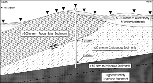
The MT station near the drill hole (see diagram Figure 1) shows a thin, near-surface conductor on top of the resistive Precambrian thrust sheet. This is a wedge of Quaternary and Tertiary sediments. Beneath the thrust, a thick conductive section of Cretaceous sediments is observed.
Figure 1 is an 11-station MT profile across the thrust.
Structural details[edit]
These data provide the following structural details:
- Thickness of Quaternary and Tertiary cover
- Thickness of Precambrian thrust sheet
- Thinning of Cretaceous sediments to the south
- Depth to top of Paleozoic sediments
- No differentiation between Paleozoic and basement
A very detailed subsurface structural map could be obtained in this area using a 3-D grid, controlled-source MT survey depicting the Precambrian-Cretaceous thrust contact and the top of the Paleozoic section.
See also[edit]
- Magnetotellurics
- Magnetotellurics survey measurements
- Magnetotelluric data acquisition
- Magnetotellurics case history: frontier basin analysis (Amazon Basin, Colombia)
- Magnetotellurics case history: rugged carbonate terrain (Highlands of Papua New Guinea)
- Magnetotellurics case history: volcanic terrain (Columbia River Plateau)
