Difference between revisions of "Minibasin"
(Initial import) |
Cwhitehurst (talk | contribs) m (added Category:Treatise Handbook 3 using HotCat) |
||
| (22 intermediate revisions by 4 users not shown) | |||
| Line 6: | Line 6: | ||
| part = Critical elements of the petroleum system | | part = Critical elements of the petroleum system | ||
| chapter = Sedimentary basin analysis | | chapter = Sedimentary basin analysis | ||
| − | | frompg = 4- | + | | frompg = 4-80 |
| − | | topg = 4- | + | | topg = 4-82 |
| author = John M. Armentrout | | author = John M. Armentrout | ||
| link = http://archives.datapages.com/data/specpubs/beaumont/ch04/ch04.htm | | link = http://archives.datapages.com/data/specpubs/beaumont/ch04/ch04.htm | ||
| Line 14: | Line 14: | ||
| isbn = 0-89181-602-X | | isbn = 0-89181-602-X | ||
}} | }} | ||
| − | |||
| − | + | A '''minibasin''' is a subdivision of a [[depocenter]] that in turn is a subdivision of a basin. Sediment thickness is the primary basis for subdividing basins into depocenters. Structural elements separate one minibasin from another within a depocenter. [[::file:Sedimentary-basin-analysis_fig4-42.png|Figure 1]] shows the structural elements that define the East Breaks 160-161 minibasin, which is bound on the north by fault A, on the east by faults B and C, and on the south by a salt-cored high. | |
==Seismic expression== | ==Seismic expression== | ||
| − | The following figure is a north-south seismic section through the East Breaks 160-161 intraslope minibasin, showing the location of the East Breaks 160-161 field. Production is from the ''Trim A'' and ''Glob alt'' reservoirs within the rollover anticline downthrown to the north bounding fault A′. Fault A′ splays southwest off regional fault A ( | + | |
| + | The following figure is a north-south seismic section through the East Breaks 160-161 intraslope minibasin, showing the location of the East Breaks 160-161 field. Production is from the ''Trim A'' and ''Glob alt'' reservoirs within the rollover anticline downthrown to the north bounding fault A′. Fault A′ splays southwest off regional fault A ([[:file:Sedimentary-basin-analysis_fig4-42.png|Figure 1]]).<ref name=ch04r86>Schanck, J. W., C. C. Cobb, and M. L. Ivey, Jr., 1988, East Breaks 160 field on the offshore Texas shelf edge: a model for deepwater exploration and development: Proceedings, 20th Annual Offshore Technology conference, p. 157–162.</ref><ref name=ch04r7>Armentrout, J. M., 1991, Paleontological constraints on depositional [[modeling]]: examples of integration of biostratigraphy and seismic stratigraphy, Pliocene–Pleistocene, Gulf of Mexico, in P. Weimer, and M. H. Link, eds., Seismic Facies and Sedimentary Processes of Submarine Fans and Turbidite Systems: New York, Springer-Verlag, p. 137–170.</ref> | ||
==Age of minibasin formation== | ==Age of minibasin formation== | ||
| − | + | <gallery mode=packed heights=200px widths=200px> | |
| + | Sedimentary-basin-analysis fig4-42.png|{{figure number|1}}An example of the structural elements that define the East Breaks 160-161 mini basin. From Armentrout et al.;<ref name=Armentrout1991>Armentrout, J. M., S. J. Malacek, P. Braithwaite, and C. R. Beeman, 1991, Seismic facies of slope basin turbidite reservoirs, East Breaks 160-161 field: Pliocene–Pleistocene, northwestern Gulf of Mexico, in P. Weimer and M. J. Link, eds., Seismic Facies and Sedimentary Processes of Submarine Fans and Turbidite Systems: New York, Springer-Verlag, p. 223–239.</ref> courtesy Springer-Verlag. | ||
| + | sedimentary-basin-analysis_fig4-44.png|{{figure number|2}}Schematic diagram of the seismic reflection profile along the west side of the East Breaks 160-161 field.<ref name=ch04r10 /> Courtesy Gulf Coast SEPM. | ||
| + | Sedimentary-basin-analysis fig4-17.png|{{figure number|3}}Map of the East Breaks-Highland study area. | ||
| + | </gallery> | ||
| − | [[file:sedimentary-basin-analysis_fig4-44.png| | + | The age of minibasin formation is determined by looking for relationships between sedimentation and [[deformation]], like faulting or folding. [[:file:sedimentary-basin-analysis_fig4-44.png|Figure 2]] is a schematic diagram of the seismic reflection profile along the west side of the East Breaks 160-161 field ([[:file:Sedimentary-basin-analysis_fig4-42.png|Figure 1]]). That reflection profile is nearly coincident with the boundary between the Galveston and High Island exploration areas ([[:file:Sedimentary-basin-analysis fig4-17.png|Figure 3]]). The diagram depicts salt-cored anticlines and [[growth fault]]s separating the [[Depocenter#Sediment_supply_rate_and_facies_patterns|progradational]] basin-filling cycles into distinct minibasins. The stratigraphic pattern shows composite depositional sequences, numbered 1 through 4, prograding into and across progressively younger growth-fault and salt-withdrawal basins. The stratigraphic boundaries outline seismic-stratigraphically defined depositional cycles calibrated by bioevents from several wells along the section.<ref name=ch04r10>Armentrout, J. M., and J. F. Clement, 1990, Biostratigraphic calibration of depositional cycles: a case study in High Island–Galveston–East Breaks areas, offshore Texas: Proceedings, Gulf Coast Section SEPM 11th Annual Research Conference, p. 21–51.</ref> Scales are approximate. |
| − | The age of formation of each minibasin can be interpreted from the relative age of expanded sedimentary section downthrown to each major growth fault or salt high. Along the cross section, the expanded section occurs in progressively younger strata. In the northernmost diagrammed minibasin, the expanded section occurs in cycles 1 and 2. In the middle minibasin, the expanded section is in cycles 2 and 3. In the southernmost minibasin (the East Breaks 160-161), the expanded section formed during cycles 3 and 4. Anew minibasin has begun to form in cycle 4 sediments basinward of the steep salt-cored upper slope. | + | The age of formation of each minibasin can be interpreted from the relative age of expanded sedimentary section downthrown to each major growth fault or salt high. Along the [[cross section]], the expanded section occurs in progressively younger strata. In the northernmost diagrammed minibasin, the expanded section occurs in cycles 1 and 2. In the middle minibasin, the expanded section is in cycles 2 and 3. In the southernmost minibasin (the East Breaks 160-161), the expanded section formed during cycles 3 and 4. Anew minibasin has begun to form in cycle 4 sediments basinward of the steep salt-cored upper slope. |
| − | ==Formation of the | + | ==Formation of the East Breaks minibasin== |
| − | Each of these minibasins formed as sea level fell and the sediment supply system prograded to the shelf edge where it oversteepened and differentially loaded slope muds. Growth | + | Each of these minibasins formed as sea level fell and the sediment supply system [[Depocenter#Sediment_supply_rate_and_facies_patterns|prograded]] to the shelf edge where it oversteepened and differentially loaded slope muds. [[Growth fault]]s developed within this unstable sediment prism and displaced mobile salt to accommodate the downbuilding sediment.<ref name=ch04r117>Winker, C. D., and M. B. Edwards, 1983, Unstable progradational clastic shelf margins: SEPM Special Publication 33, p. 139–157.</ref> This process continued until the salt was completely displaced and the downbuilding sediments welded with the sediments underlying the displaced salt.<ref name=ch04r110>West, D. B., 1989, [http://archives.datapages.com/data/bulletns/1988-89/data/pg/0073/0012/1450/1472.htm Model for salt deformation on deep margin of central Gulf of Mexico basin]: AAPG Bulletin, vol. 73, p. 1472–1482.</ref> Once the sediment-on-sediment welding occurred, the fault system either propagated downward or locked up, resulting in the basin filling to the equilibrium profile of the sea floor. The next cycle of minibasin downloading, growth fault development, and salt withdrawal stepped basin-ward to the next deformable site. That site could be either at the shelf/slope break or within an upper slope valley. |
==See also== | ==See also== | ||
| + | * [[East Breaks petroleum system]] | ||
* [[Minibasins and petroleum systems]] | * [[Minibasins and petroleum systems]] | ||
* [[Petroleum systems]] | * [[Petroleum systems]] | ||
| Line 45: | Line 50: | ||
[[Category:Critical elements of the petroleum system]] | [[Category:Critical elements of the petroleum system]] | ||
[[Category:Sedimentary basin analysis]] | [[Category:Sedimentary basin analysis]] | ||
| + | [[Category:Treatise Handbook 3]] | ||
Latest revision as of 18:44, 21 March 2022
| Exploring for Oil and Gas Traps | |

| |
| Series | Treatise in Petroleum Geology |
|---|---|
| Part | Critical elements of the petroleum system |
| Chapter | Sedimentary basin analysis |
| Author | John M. Armentrout |
| Link | Web page |
| Store | AAPG Store |
A minibasin is a subdivision of a depocenter that in turn is a subdivision of a basin. Sediment thickness is the primary basis for subdividing basins into depocenters. Structural elements separate one minibasin from another within a depocenter. [[::file:Sedimentary-basin-analysis_fig4-42.png|Figure 1]] shows the structural elements that define the East Breaks 160-161 minibasin, which is bound on the north by fault A, on the east by faults B and C, and on the south by a salt-cored high.
Seismic expression
The following figure is a north-south seismic section through the East Breaks 160-161 intraslope minibasin, showing the location of the East Breaks 160-161 field. Production is from the Trim A and Glob alt reservoirs within the rollover anticline downthrown to the north bounding fault A′. Fault A′ splays southwest off regional fault A (Figure 1).[1][2]
Age of minibasin formation
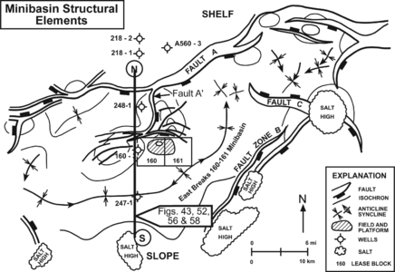
Figure 1 An example of the structural elements that define the East Breaks 160-161 mini basin. From Armentrout et al.;[3] courtesy Springer-Verlag.
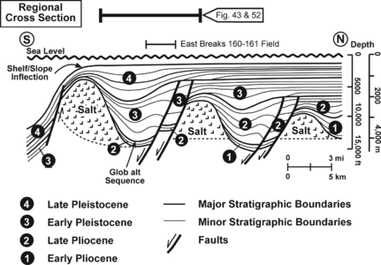
Figure 2 Schematic diagram of the seismic reflection profile along the west side of the East Breaks 160-161 field.[4] Courtesy Gulf Coast SEPM.
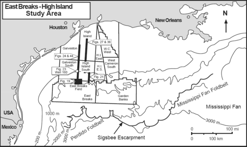
Figure 3 Map of the East Breaks-Highland study area.


The age of minibasin formation is determined by looking for relationships between sedimentation and deformation, like faulting or folding. Figure 2 is a schematic diagram of the seismic reflection profile along the west side of the East Breaks 160-161 field (Figure 1). That reflection profile is nearly coincident with the boundary between the Galveston and High Island exploration areas (Figure 3). The diagram depicts salt-cored anticlines and growth faults separating the progradational basin-filling cycles into distinct minibasins. The stratigraphic pattern shows composite depositional sequences, numbered 1 through 4, prograding into and across progressively younger growth-fault and salt-withdrawal basins. The stratigraphic boundaries outline seismic-stratigraphically defined depositional cycles calibrated by bioevents from several wells along the section.[4] Scales are approximate.
The age of formation of each minibasin can be interpreted from the relative age of expanded sedimentary section downthrown to each major growth fault or salt high. Along the cross section, the expanded section occurs in progressively younger strata. In the northernmost diagrammed minibasin, the expanded section occurs in cycles 1 and 2. In the middle minibasin, the expanded section is in cycles 2 and 3. In the southernmost minibasin (the East Breaks 160-161), the expanded section formed during cycles 3 and 4. Anew minibasin has begun to form in cycle 4 sediments basinward of the steep salt-cored upper slope.
Formation of the East Breaks minibasin
Each of these minibasins formed as sea level fell and the sediment supply system prograded to the shelf edge where it oversteepened and differentially loaded slope muds. Growth faults developed within this unstable sediment prism and displaced mobile salt to accommodate the downbuilding sediment.[5] This process continued until the salt was completely displaced and the downbuilding sediments welded with the sediments underlying the displaced salt.[6] Once the sediment-on-sediment welding occurred, the fault system either propagated downward or locked up, resulting in the basin filling to the equilibrium profile of the sea floor. The next cycle of minibasin downloading, growth fault development, and salt withdrawal stepped basin-ward to the next deformable site. That site could be either at the shelf/slope break or within an upper slope valley.
See also
References
- ↑ Schanck, J. W., C. C. Cobb, and M. L. Ivey, Jr., 1988, East Breaks 160 field on the offshore Texas shelf edge: a model for deepwater exploration and development: Proceedings, 20th Annual Offshore Technology conference, p. 157–162.
- ↑ Armentrout, J. M., 1991, Paleontological constraints on depositional modeling: examples of integration of biostratigraphy and seismic stratigraphy, Pliocene–Pleistocene, Gulf of Mexico, in P. Weimer, and M. H. Link, eds., Seismic Facies and Sedimentary Processes of Submarine Fans and Turbidite Systems: New York, Springer-Verlag, p. 137–170.
- ↑ Armentrout, J. M., S. J. Malacek, P. Braithwaite, and C. R. Beeman, 1991, Seismic facies of slope basin turbidite reservoirs, East Breaks 160-161 field: Pliocene–Pleistocene, northwestern Gulf of Mexico, in P. Weimer and M. J. Link, eds., Seismic Facies and Sedimentary Processes of Submarine Fans and Turbidite Systems: New York, Springer-Verlag, p. 223–239.
- ↑ 4.0 4.1 Armentrout, J. M., and J. F. Clement, 1990, Biostratigraphic calibration of depositional cycles: a case study in High Island–Galveston–East Breaks areas, offshore Texas: Proceedings, Gulf Coast Section SEPM 11th Annual Research Conference, p. 21–51.
- ↑ Winker, C. D., and M. B. Edwards, 1983, Unstable progradational clastic shelf margins: SEPM Special Publication 33, p. 139–157.
- ↑ West, D. B., 1989, Model for salt deformation on deep margin of central Gulf of Mexico basin: AAPG Bulletin, vol. 73, p. 1472–1482.
External links
| find literature about Minibasin |