Search results
Jump to navigation
Jump to search
There is a page named "Basin" on this wiki. See also the other search results found.
Page title matches
File:Sedimentary-basin-analysis fig4-25.png (1,964 × 1,305 (1.17 MB)) - 19:19, 30 January 2014
File:Sedimentary-basin-analysis fig4-53.png (1,256 × 842 (52 KB)) - 20:05, 30 January 2014
File:800px-Photograph - Seven Lakes Basin - 20050918.jpg (800 × 600 (168 KB)) - 13:51, 4 January 2017
File:Sedimentary-basin-analysis fig4-41.png (1,646 × 1,162 (485 KB)) - 18:51, 30 January 2014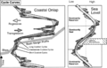
File:Sedimentary-basin-analysis fig4-34.png (1,608 × 1,030 (308 KB)) - 19:36, 30 January 2014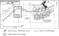
File:Sedimentary-basin-analysis fig4-13.png (780 × 476 (55 KB)) - 19:07, 30 January 2014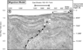
File:Sedimentary-basin-analysis fig4-56.png (1,632 × 994 (691 KB)) - 19:51, 30 January 2014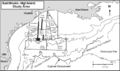
File:Sedimentary-basin-analysis fig4-17.png (866 × 515 (76 KB)) - 19:21, 30 January 2014
File:Sedimentary-basin-analysis fig4-57.png (1,402 × 1,687 (552 KB)) - 20:07, 30 January 2014
File:Sedimentary-basin-analysis fig4-54.png (1,618 × 639 (68 KB)) - 18:52, 30 January 2014
File:Sedimentary-basin-analysis fig4-35.png (1,662 × 891 (348 KB)) - 19:37, 30 January 2014
File:Sedimentary-basin-analysis fig4-14.png (780 × 463 (61 KB)) - 19:08, 30 January 2014
File:Sedimentary-basin-analysis fig4-44.png (1,454 × 1,013 (98 KB)) - 19:52, 30 January 2014
File:Sedimentary-basin-analysis fig4-22.png (730 × 571 (64 KB)) - 19:22, 30 January 2014
File:Sedimentary-basin-analysis fig4-58.png (1,594 × 875 (61 KB)) - 20:08, 30 January 2014
File:Sedimentary-basin-analysis fig4-55.png (1,660 × 1,158 (586 KB)) - 18:53, 30 January 2014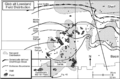
File:Sedimentary-basin-analysis fig4-40.png (1,683 × 1,114 (154 KB)) - 19:38, 30 January 2014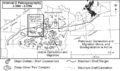
File:Sedimentary-basin-analysis fig4-15.png (760 × 448 (62 KB)) - 19:09, 30 January 2014
File:Sedimentary-basin-analysis fig4-45.png (1,995 × 1,163 (98 KB)) - 19:53, 30 January 2014
File:Sedimentary-basin-analysis fig4-24.png (2,355 × 1,477 (691 KB)) - 19:23, 30 January 2014


Page text matches
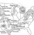
File:MainPageBasinCenteredGasSystems.jpg Basin-centered gas systems: global distribution(400 × 408 (63 KB)) - 19:32, 13 July 2015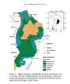
File:Parana 1.jpg Geological Map of the Paraná Basin. Milani E. J. 2004.(610 × 728 (86 KB)) - 17:38, 24 June 2015- ...pts], ''in'' Peters, Kenneth E., David J. Curry, and Marek Kacewicz, eds., Basin modeling: New horizons in research and applications: [http://store.aapg.org ...WnEw&sig2=PhylqTWS83U9eCDYb556qg&bvm=bv.70810081,d.aWw Australian Eromanga Basin]2 KB (268 words) - 19:15, 25 June 2015
- | chapter = Sedimentary basin analysis ...the distribution of sediments, and deform the contained rocks. Aspects of basin analysis, as presented in this chapter, focus on several scales:4 KB (512 words) - 16:26, 18 February 2022
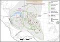
File:GiacomoneEtAlFigure6.jpg Location map of the Permian Basin, with its major structural features and drilled wells.(744 × 524 (88 KB)) - 20:03, 29 October 2021
File:M114CH08FG02.jpg ...n of the siliciclastic sequence presents the main formations of the Llanos Basin. The early Paleocene Barcos (sandy) and Los Cuervos (shally) formations are(700 × 381 (50 KB)) - 18:09, 7 January 2019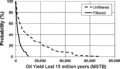
File:H4CH12FG12.JPG ...Townsley, in Peters, Kenneth E., David J. Curry, and Marek Kacewicz, eds., Basin modeling: New horizons in research and applications: AAPG Hedberg Series no(600 × 346 (51 KB)) - 21:41, 13 July 2015- ...pts], ''in'' Peters, Kenneth E., David J. Curry, and Marek Kacewicz, eds., Basin modeling: New horizons in research and applications: [http://store.aapg.org703 bytes (90 words) - 19:50, 25 June 2015
File:BasinCenteredGasFig14.jpg ...ard projection of the Colorado Mineral Belt (CMB). From Law, Ben E., 2002, Basin-centered gas systems: AAPG Bulletin, v. 86, no. 11, p. 1891-1919.(400 × 478 (53 KB)) - 16:30, 11 March 2015
File:H4CH12FG13.JPG ...Townsley, in Peters, Kenneth E., David J. Curry, and Marek Kacewicz, eds., Basin modeling: New horizons in research and applications: AAPG Hedberg Series no(600 × 480 (128 KB)) - 21:42, 13 July 2015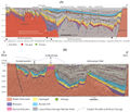
File:M114CH03FG03.jpg ...Formation reservoirs. By contrast, reservoirs in the southern part of the basin are at burial depths present day of ca. 3 km and have not been significantl(700 × 600 (112 KB)) - 17:49, 4 January 2019
File:H4CH12FG11.JPG ...Townsley, in Peters, Kenneth E., David J. Curry, and Marek Kacewicz, eds., Basin modeling: New horizons in research and applications: AAPG Hedberg Series no(600 × 322 (73 KB)) - 21:40, 13 July 2015- ...stratigraphic trap potential using the [[sequence stratigraphy]] approach. Basin-fill analysis is looking for [[Stratigraphic trap|stratigraphic]] or [[comb * [[Procedure for basin-fill analysis]]1 KB (189 words) - 18:53, 4 February 2022
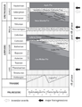
File:2.png Figure 2. Jurassic and Lower Cretaceous lithostratigraphy of the Neuquén Basin. Based on Spalletti & Veiga (2007).(376 × 491 (118 KB)) - 16:48, 26 June 2015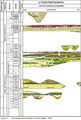
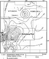
File:Guara 02.jpg Stratigraphic diagram of Paraná Basin. Fm. Taquarembó is the Guará Formation correlate in Uruguay (from Milani,(1,113 × 1,648 (427 KB)) - 16:19, 24 June 2015- [[File:SanJuanBasinUSGS.jpg|thumb|300px|Map of San Juan Basin, Colorado-New Mexico, USA. U.S. Geological Survey.]] ...nd vicinity], in C. E. Turner-Peterson, E. S. Santos, and N. S. Fishman, A Basin Analysis Case Study: Morrison Formation, Grants Uranium Region, New Mexico:3 KB (411 words) - 15:01, 11 January 2016
- ...pts], ''in'' Peters, Kenneth E., David J. Curry, and Marek Kacewicz, eds., Basin modeling: New horizons in research and applications: [http://store.aapg.org688 bytes (93 words) - 19:04, 14 March 2016
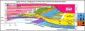
File:GiacomoneEtAlFigure7.jpg Upper Permian Stratigraphy of North West Shelf of the Delaware Basin.(940 × 342 (119 KB)) - 20:03, 29 October 2021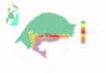
File:Guara 01.jpg Simplified geological map of Paraná Basin in Rio Grande do Sul state, Brazil. (modified from Scherer & Lavina, 2005)(3,364 × 2,331 (1.18 MB)) - 16:14, 24 June 2015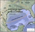
File:GiacomoneEtAlFigure4.jpg Location map of the United States (northern) Gulf of Mexico Super Basin.(678 × 626 (158 KB)) - 19:58, 29 October 2021


