Delta plain, subaqueous
| Sandstone Depositional Environments | |
| |
| Series | Memoir |
|---|---|
| Chapter | Deltaic environments of deposition |
| Author | J. M. Coleman and D. B. Prior |
| Link | Web page |
| PDF file (requires access) | |
| Store | AAPG Store |
The subaqueous delta is that part of the delta plain lying below low-tide level and extending seaward to that area actively receiving fluvial sediment. This area ranges in water depth from 50 to 300 m and in width from a few kilometers to tens of kilometers. It is the foundation across which progradation of the subaerial delta must proceed. Most commonly, the subaqueous delta is characterized by a seaward fining of sediments, sands and coarser clastics being deposited near the river mouths, and finer grained sediments settling farther offshore from suspension in the water column or as a result of downslope mass-movement processes. The seawardmost section of the subaqueous delta is commonly referred to as the prodelta environment and is composed of the finest material deposited from suspension.
Prodelta silts and clays grade landward and upward vertically into the coarser silts and sands of distal bar. Directly at the mouths of the active distributaries lie the coarsest sand deposits. These deposits are commonly referred to as the distributary-mouth bar. If sediments deposited seaward of the river mouth accumulate faster than subsidence or removal of sediments by marine processes occurs, deltaic progradation will take place and the subaerial deltaic deposits will overlie the uppermost parts of the subaqueous delta, forming a complete delta sequence.
Distributary-mouth-bar deposits[edit]
At river mouth, seaward-flowing water leaves the confines of channel banks and spreads and mixes with ambient waters of the receiving basin. This point is the dynamic dissemination for sediments which contribute to continued delta progradation and is responsible for forming one of the major sand bodies associated with deltaic sequences--the distributary-mouth-bar deposits.
The geometry of the river mouth and the distributary-bar topography are influenced by effluent dynamics and marine processes. The resulting geometry and distribution of river-mouth-bar sand bodies is determined by riverine flow conditions, density contrast between issuing ambient water, bottom slope seaward of the mouth, tidal range and tidal currents within the lower river channel, and the ability of waves and other forces to redistribute the fluvial clastics. Comprehensive studies, both theoretical and field, of river-mouth processes have been published by Bates,[1] Scruton,[2] Jopling,[3] Borichansky and Mikhailov,[4] Wright and Coleman,[5] and Wright.[6]
The most important river-mouth processes are those enabling river effluent to interact with ambient marine waters, resulting in deconcentration of outflow momentum and consequent loss of transporting ability. These interactions yield specific geometry to the resulting distributary-mouth-bar deposit. The geometry of the resulting sand body depends on the relative roles of three primary forces: (a) the inertia of the issuing water and associated turbulent diffusion; (b) friction between the effluent and the bed just seaward of the mouth; and (c) buoyancy resulting from density contrasts between issuing and ambient fluids.
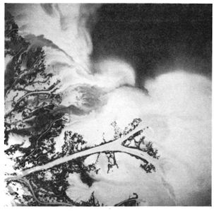
Figure 1 High-altitude photograph of bifurcating distributary channel in the Mississippi River delta.[7]
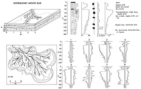
Figure 2 Summary diagram illustrating the major characteristics of the distributary-mouth bar deposits in the subaqueous delta plain.[7]


In the absence of high tidal range and extremely strong marine energy, the distributary channel pattern is often one of seaward bifurcation (Figure 1). Because of this bifurcating channel pattern, the distributary-mouth bars at each of the river mouths often merge and form a near-continuous sand strip around the entire periphery of the delta. Shallow offshore slopes and low wave and tide action favor this type of distributary pattern, and turbulent diffusion within the water mass becomes restricted to the horizontal. Bottom friction plays a major role in causing effluent deceleration and expansion. Initially a broad, arcuate radial bar will form at the mouth. However, as deposition on the bar continues, natural subaqueous levees will develop beneath the lateral boundaries of the expanding effluent, where velocity gradients are generally steepest. Development of subaqueous levees tends to inhibit further increases in effluent expansion, so that with continuing bar accretion continuity can no longer be maintained simply by increasing effluent width. As the central part of the bar grows upward, channelization develops along the threads of maximum turbulence, which tend to follow the subaqueous levee. This process results in formation of a bifurcating channel, which has a triangular middle ground shoal separating diverging channel arms. This type of channel pattern is well displayed in the high-altitude photograph shown as Figure 1.

The upper left diagram of Figure 2 illustrates schematically the process of a bifurcated channel. In the cross sections on this panel, the three major units illustrated include lower prodelta clays, overlain by alternating silt and sand units of the distal bar, and uppermost, distributary-mouth-bar sands. As the diagram shows, distributary-mouth-bar sands form a nearly continuous sand body extending laterally large distances. The upper right-hand diagram shows the most common vertical sequence within the distributary-mouth-bar deposits and some of its characteristics. The unit generally displays a coarsening-upward sequence in which depositional dips are extremely low, rarely exceeding 1° except in areas where slump deposits result in high angles within the mass-moved sediment. Figure 3A and B illustrates some of the characteristic structures found within the lowermost units of prodelta clays. Parallel, colored clay laminations, thin graded silt and silty clay parallel laminations, bioturbation (generally confined to the clay laminations), and slump structures are common within the prodelta deposits. Microfaunal remains generally indicate marine deposition, and diversity of species is generally quite high, indicating an open, inner to outer shelf depositional environment. These deposits display most of the characteristics of normal marine shelf deposits and are differentiated only by their rate of accumulation.
For a given length of time, prodelta deposits are thicker (because of high sedimentation) than an equivalent section of normal marine shelf deposits. Rapid deposition often results in slightly lower amounts of bioturbation and deposits displaying excess pore fluid pressures. Graded bedding zones are sometimes present in the prodelta deposits, but are rarely found in normal marine shelf deposits. X-ray radiography of the cores reveals that many of the parallel laminations are defined either by inclusions of diagenetic origin or extremely slight differences in textural characteristics. Because of the high rates of deposition normally associated with prodelta deposits, intense bioturbation is usually confined only to the lowermost parts of the deposit, where it grades downward into norma open-marine shelf environments, that often show intense bioturbation.
Progressing upward within the vertical sequence, the distal bar (also referred to as delta front or delta platform) overlies the prodelta facies. This environment is the seaward-sloping margin of the advancing delta sequence. Increase in sedimentation rates and coarseness of sediments are characteristic of this environmental sequence.
Lithologically, the sediments primarily consist of laminated silts and clays containing numerous thin-graded and cross-laminated sand-silt layers. Depositional slopes, although higher than in any other subaqueous delta environment, rarely exceed 0.5 to 0.75°. Core photographs in Figure 3D-F show some of the more common structural types associated with distal-bar deposits. Lower parts of the distal bar show small burrows and shell remains generally scattered throughout the deposits, that often result in partial destruction of parallel and lenticular laminations (Figure 3D). Higher in the distal bar deposits, a wide variety of structures associated with both oscillatory and unidirectional currents become much more common. Sedimentary structures such as small-scale cross laminae, starved current ripples, small scour and fill, and graded sand units become much more common. In general the amount of clays and silty clays begins to diminish within the section.
Figure 3F illustrates the wide variety of sedimentary structures found within only a 20-cm core from the uppermost parts of this environmental sequence. The clays, when present, are generally extremely thin, with lateral continuity of individual clay laminations usually low. Distal-bar deposits represent potential reservoirs in the subsurface, and numerous gas fields in such deposits have been located in the Pleistocene deposits of offshore Texas.
The distributary-mouth bar is the area of shoaling associated with the seaward terminus of a distributary-mouth channel. Shoaling is a direct consequence of a decrease in velocity and a reduction in carrying power of a stream as it leaves the confines of its channel. Accumulation rates are extremely high, probably higher than in any other environment associated with the delta. In some places depositional rates of coarse sediments at the mouth of the Mississippi reach 1 to 3 m per year.
The sediments are constantly subjected to reworking, not only by stream currents but by waves generated in the open-marine waters beyond the channel mouth. A general understanding of the processes and mode of formation of the distributary-mouth bar is critical to understanding the evolution and vertical relationships illustrated in Figure 2. As the low-density, turbid, fresh river water flows out of the distributary mouth over denser saline marine waters, the lighter effluent waters expand and lose velocity. Coarser sediments (the sands) settle rapidly, both from suspension and bedload migration, and almost all of the sand is deposited within the vicinity of the distributary mouth.
Because of variations in turbulence at the river mouth and different process intensities between low river stage and high river stage, silts and clays will occasionally be deposited with sands in this environment. However, reworking by marine and riverine processes results in cleaning and sorting of the sediments. As a result, the distributary-mouth bar commonly consists of clean, well-sorted sand and thus is obviously a potential reservoir rock for hydrocarbons. The remaining finer grained suspended load carried by the river is distributed widely by the expanding river effluent and forms distal bar and prodelta environments.
The most common sedimentary structure consists of a variety of small-scale cross laminae and current ripple drift types (Figure 3G-I). Quite often mass-movement processes such as small localized slumps result in distorted laminations. This is particularly true near lower sections of the distributary-mouth-bar sequence, where over-pressured sediments are much more common. Figure 3G illustrates one type of slump structure commonly seen. Near the top of the distributary-mouth bar large accumulations of river-transported organic debris are often present. Water-saturated logs and other organic debris are transported down the rivers in times of flood and discharged into the nearshore zone, where wave action grinds down the coarser wood particles into large concentrations of organic debris. Figure 3I is a core showing some of the organic laminations present within the upper part of the sand body.
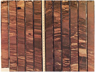
Figure 4 Part of a continuously cored boring through the distributary-mouth bar sequence. This section represents the lower part of the distal bar deposit. Diameter of cores is 8 cm (3 in.).[7]
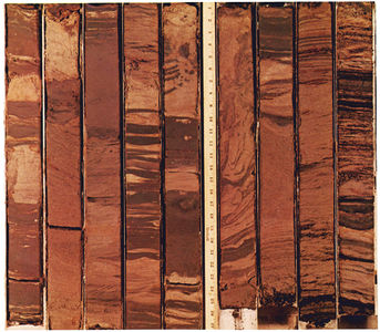
Figure 5 Part of a continuously cored boring through the distributary-mouth bar sequence. This section represents the lower part of the distributary-mouth bar deposit. Diameter of cores is 8 cm (3 in.).[7]
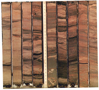
Figure 6 Part of a continuously cored boring through the distributary-mouth bar sequence. This section represents the upper part of the distributary-mouth bar deposits. Diameter of cores is 8 cm (3 in.).[7]


Directly capping the distributary-mouth bar are a variety of overbank splays and shallow-bay deposits. These overbank splays are commonly referred to as natural levees. During annual river floods, the river stage normally tops the distributary channel, and numerous small overbank or crevasse splays result. Each splay will be maintained for one or several years until it builds up or grades the natural levee to flood level, and then it will cease activity. Thus, capping the distributary-mouth bar is commonly a series of small coarsening-upward sequences representative of these splay deposits. Deposits are characterized by a wide variety of sedimentary structures, with climbing current ripples and small-scale cross laminae being the most common in the coarser grained parts. Figure 3J illustrates some of the ripple-type structures present in this environment.
Figures 4, 5, and 6 show parts of a continuously cored boring (approximately 130 m in depth) taken through the distributary-mouth-bar deposits in the Mississippi River delta. Figure 19 illustrates the sedimentary structures in the core representing lower sections of the distal-bar deposits. Even within this 10 m section of core the change from a predominance of clay in the lower part of the distal bar to a predominance of fine, silty and sandy laminations is apparent. Several regions show highly contorted bedding believed to be primarily due to slumping rather than coring processes.
Figure 5 represents approximately 7 m of core taken in the lower segment of the distributary-mouth-bar deposits. The predominance of sand laminations intercalating with silty clay and silt laminations is apparent. Darker colored zones in lower parts of the core represent transported organic debris. Also shown in this sequence is a section of highly contorted core, once more believed to be the result of slumping rather than core disturbance. The predominance of small-scale ripple laminations is obvious within the sequence. Figure 6 represents 7 m of cored boring taken from the uppermost part of the distributary-mouth-bar deposit. The core consists primarily of sand deposits, with sand-sized particles making up 80 to 90% of the total unit. Dark layers are stratification representing transported organic debris. Note that most of the stratification is nearly flat-lying, and few or no steep dips exist, except for small-scale cross-bedding. One core indicates tremendous disturbance and distortion of lamination and undoubtedly represents a portion of a slump block. Ripple laminations, climbing ripples, and larger scale trough cross-laminations are the most dominant sedimentary structure types.
The lower two diagrams on Figure 2 represent a sand isopach map of a distributary-mouth-bar system in which individual distributary-mouth bars have merged, forming a delta-front sand body type. The distributary pattern is shown as solid dark lines. A boring through the distributary channel itself would show very erratic sand distribution in the distributary channel. Electric-log responses and their variations are shown in the lower right-hand diagram of Figure 2. Most borings show a coarsening-upward sequence, with the sand body varying in thickness, depending on the location of the core with reference to the distributary channels themselves. In general, the nearer the boring to the axis of the distributary, the sharper the base of the sand body, and gradational contacts become less well defined. Distally (away from the distributary-channel axis), the sequence displays a much greater tendency toward a large transition from distal bar to distributary-mouth bar.
Literature on distributary-mouth-bar environments.[8] [9] [10] [11] [12] [13] [14] [2] [15] [16] [17] [18] [19] [20] [21] [22] [23] [24] [25] [26] [27] [28] [29] [30] [31] [32] [33] [34]
River-mouth tidal-ridge deposits[edit]
The distributary-mouth-bar sequence just described represents the most common type of vertical sequence within many deltaic deposits. In deltas debouching into macro- or high-tidal ranges and into narrow, elongate basins, however, tidal processes play an important role in dispersing and redistributing fluvial clastics. Where rivers debouch into narrow, elongate basins where tidal range creates strong bidirectional transport, large linear tidal ridges within and just seaward of the river mouth are common topographic forms associated with the distributary-mouth-bar environment. These ridges are commonly composed of coarse fluvial sand and vary in size, some displaying heights exceeding 30 m above the adjacent swales. The ridges are commonly oriented parallel with the river channels forming elongate prominent sand deposits.
Although in present world deltas, river-mouth tidal ridges form one of the major sand bodies associated with rivers prograding into basins displaying macro- or high-tidal ranges, literature on these river-mouth tidal ridges is sparse. Many past river deltas undoubtedly existed in similar environmental settings, and they must therefore form prominent sand bodies in many ancient-rock deltaic sequences. Major literature associated with these types of features includes that of Off,[35] Keller and Richards,[36] Reineck and Singh,[37] Houbolt,[38] Klein,[39] Ludwick,[40] Meckel,[41] and Wright and Thom.[42]
River distributaries debouching into high-tidal regions commonly display a funnel-shaped configuration, with widths attaining several kilometers. Linear, elongate tidal ridges aligned parallel with each other in the direction of tidal flow are the most prominent channel and river mouth accumulation forms. They appear to be directly related to bidirectional sediment transport patterns, high-tidal amplitudes, and tidal-current symmetry. Tidal ridges described by Coleman[33] and Wright and Thum[43] in the Ord River are typical of the study shoals found in river-dominated deltaic distributaries.
Those tidal ranges in the Ord River range in relief from 10 to 22 m and compositely account for over 5 x 10⁶ cu m of total sand accumulation. Tidal ridges average roughly 2 km in length and 300 m in width, with crests emergent or near the surface at low tide. A few are permanently emergent and vegetated by mangrove. In some deltas, tidal ridges attain extreme lengths of 10 to 15 km. Deltas displaying similar types of shoals have been described by Off[35] and Meckel.[41] Meckel[41] referred to tidal ridges at the mouth of the Colorado delta, Gulf of California, as tidal bars. Ridges at the mouth of the Colorado display relief of 7 to 10 m and a crest to crest spacing of several kilometers. In cross-sect on they vary from roughly symmetrical to distinctly asymmetrical, with steep sides commonly facing the downstream direction of tidal propagation.
Although little coring has been done on these types of deposits, Figure 22 is an attempt to summarize data presently available. The upper left diagram illustrates the distribution of some of the tidal ridges seaward of the mouth of the Shatt-el-Arab River delta, which flows into the Persian Gulf. Lengths of the tidal ridges at the river mouth range from 5 to 15 km, with some of the larger ridges displaying widths of 2 km. General spacing of the ridges across the distributary-mouth-bar area ranges from a minimum of about 2 km to slightly over 5 km. The upper righthand diagram shows a typical vertical sequence resulting from river-mouth progradation and lateral migration of ridges. In general, the coarsening upward sequence displayed agrees quite well with data presented from the lower Colorado delta[41] and Ord River delta.[33]
Sand units are generally well sorted and display a variety of small-scale and large-scale cross-stratifications. One of the more common sedimentary structures within sand bodies is the small-scale bidirectional or herring-bone stratification type. Shell debris is generally common, both scattered throughout sand deposits and concentrated into thin lag-type deposits. Parallel sand layers are common throughout the entire sequence of sandy deposits and probably result from deposition during the upper flow regime, especially during low tide, when water depths across the shoals are quite low and velocities are quite high.
Thompson[44] measured flood and ebb currents of 100 to 135 cm/sec, with maximum velocities of more than 200 cm/sec, in bars at the mouth of the Colorado. Although exposures are generally limited within the tidal ridges, shallow pits and box cores near the tops of many tidal ridges have large-scale trough cross-bedding, with the probabilities that within the uppermost sequences, large-scale cross-bedding could be preserved. Directional properties throughout the sequence generally show a net downstream direction; however, upstream-oriented cross-stratification is not uncommon, and thus current roses would probably show the bidirectional pattern.

The lower left diagram in Figure 7 depicts the probable sand isopach associated with a river-mouth tidal-ridge environment. This particular isopach is based on limited data and is patterned after the Ord River mouth. Sand thickness throughout the isopached interval would undoubtedly vary and be concentrated into the linear type of ridges seen topographically in modern deltas. Log response (lower right diagram, Figure 7) displays extreme variation because of sand thickness; the base of the sand deposit displays a gradational contact to a rather abrupt basal scour plane associated with those ridges of prominent scour. In general, the ridges tend to display the coarsest and best sorted sand units and are illustrated by core holes 3, 5 and 7.
In an upstream direction, depicted by core hole 8, it is highly probable that the base of the sand represents a scoured surface, and thus the sand body displays an extremely sharp base. In drop cores and samples from interridge-ridge areas, sediments tend to be much more poorly sorted. Clay clasts, organic trash, and shell lags are common. It is probable that electric-log response would show extremely erratic and ragged types of patterns as indicated in bore holes 4 and 6.
Although data are sparse from this type of environmental setting, the writers believe such sand bodies to be indeed common in ancient rock sequences, and until a larger number of cored borings and cores on and through these river-mouth tidal ridges are obtained, data presented in Figure 7 remains somewhat speculative. However, observations from literature cited above indicate that the general nature of the deposits is as illustrated in the vertical sequence of Figure 7.
Subaqueous slump deposits[edit]
See also[edit]
References[edit]
- ↑ Bates, C. C., 1953, Rational theory of delta formation: AAPG Bulletin, v. 37, p. 2119-2162.
- ↑ 2.0 2.1 Scruton, P. C., 1960, Delta building and the deltaic sequence: in F. P. Shepard et al., eds., Recent sediments, northwest Gulf of Mexico: AAPG Special Publication 21, p. 82-102.
- ↑ Jopling, A. V., 1963, Hydraulic studies on the origin of bedding: Sedimentology, v. 2, p. 115-121.
- ↑ Borichansky, L. S., and V. N. Mikhailov, 1966, Interaction of river and sea water in the absence of tides: in Problems of the humid tropic zone deltas and their implications: UNESCO, Proc. Dacca Symp., p. 175-180.
- ↑ Wright, L. D., and J. M. Coleman, 1971, Effluent expansion and interfacial mixing in the presence of a salt wedge, Mississippi River delta: Jour. Geophys. Research, v. 76, no. 36, p. 8649-8661.
- ↑ Wright, L. D., 1974, Mississippi River mouth processes: effluent dynamics and morphologic development: Jour. Geology, v. 82, p. 751-778.
- ↑ 7.0 7.1 7.2 7.3 7.4 7.5 7.6 Coleman, J. M., and D. B. Prior, 1981, Deltaic environments of deposition in P. A. Scholle and D. Spearing, eds., Sandstone depositional environments: AAPG Memoir 31, p. 139-178.
- ↑ Johnston, W. A., 1922, The character of the stratification of the sediments in the recent delta of the Fraser River delta, British Columbia, Canada: Jour. Geology, v. 30, p. 115-129.
- ↑ Arnborg, L. E., 1948, The delta of the Angerman River: Geog. Ann., Stockholm, v. 30, p. 673-690.
- ↑ Fisk, H. N., et al, 1954, Sedimentary framework of the modern Mississippi delta: Jour. Sed. Petrology, v. 24, p. 76-99.
- ↑ Fisk, H. N., 1955, Sand facies of Recent Mississippi delta deposits: 4th World Petroleum Cong. Proc., Rome, sec. 1, p. 377-398.
- ↑ Fisk, H. N., 1961, Bar-finger sands of the Mississippi delta: in J. A. Peterson and J. C. Osmond, eds., Geometry of sandstone bodies: AAPG Spec. Pub., p. 29-52.
- ↑ Fisk, H. N., and E. McFarlan, Jr., 1955, Late Quaternary deltaic deposits of the Mississippi River--local sedimentation and basin tectonics: in A. Poldervaart, ed., Crust of the earth, a symposium: Geol. Soc. America Spec. Paper 62, p. 279-302.
- ↑ Kruit, C., 1955, Sediments of the Rhone delta, 1, Grain size and microfauna: Kon. Nederlands Geol. Mijnb. Gen. Verhand., v. 15, p. 397-499.
- ↑ Scruton, P. C., 1955, Sediments of the eastern Mississippi Delta: in Finding ancient shorelines: SEPM Spec. Pub. 3, p. 21-51.
- ↑ Scruton, P. C., 1956, Oceanography of Mississippi Delta sedimentary environments: AAPG Bull., v. 40, p. 2864-2952.
- ↑ Shepard, F. P., 1956, Marginal sediments of the Mississippi delta: AAPG Bulletin, v. 40, p. 2537-2623.
- ↑ Shepard, F. P., F. B. Phleger, and T. H. van Andel, eds., 1960, Recent sediments, northwest Gulf of Mexico: AAPG Special Publication 21, 394 p.
- ↑ Allen, J. R. L., 1965, Late Quaternary Niger delta and adjacent areas: AAPG Bulletin, v. 49, p. 547-600.
- ↑ Allen, J. R. L., 1970, Sediments of the modern Niger Delta: in J. P. Morgan, ed., Deltaic sedimentation: modern and ancient: SEPM Spec. Pub. 15, p. 138-151.
- ↑ Kolb, C. R., and J. R. Van Lopik, 1966, Depositional environments of the Mississippi River deltaic plain, southeastern Louisiana, in M. L. Shirley and J. A. Ragsdale, eds., Deltas: Houston Geol. Soc., p. 17-62.
- ↑ Mikhailov, V. N., 1966, Hydrology and formation of river mouth bars: in Scientific problems of the humid tropic zone deltas and their implications: UNESCO, Proc. Dacca Symp., p. 59-64.
- ↑ Shirley, M. L., ed., 1966, Deltas: Houston Geol. Soc., 251 p.
- ↑ Fisher, W. L., and J. H. McGowen, 1967, Depositional systems in the Wilcox Group of Texas and their relationship to oil and gas: Gulf Coast Assoc. Geol. Soc. Trans., v. 17, p. 105-125.
- ↑ Oomkens, E., 1967, Depositional sequences and sand distribution in a deltaic complex: a sedimentological investigation of the post-glacial Rhone delta complex: Geologie en Mijnbouw, v. 46, no. 7, p. 265-278.
- ↑ Oomkens, E., 1974, Lithofacies relations in the Late Quaternary Niger delta complex: Sedimentology, v. 21, p. 195-221.
- ↑ Coleman, J. M., S. M. Gagliano, and W. G. Smith, 1970, Sedimentation in a Malaysian high tide tropical delta: in J. P. Morgan, ed., Deltaic sedimentation: modern and ancient: SEPM Spec. Pub. 15, 312 p.
- ↑ Ferm, J. C., 1970, Allegheny deltaic deposits: in J. P. Morgan, ed., Deltaic sedimentation: Modern and ancient: SEPM Spec. Pub. 15, 312 p.
- ↑ Ferm, J. C., 1977, Allegheny deltaic deposits: in F. B. van Houten, ed., Ancient continental deposits: Benchmark Papers in Geology: Stroudsburg, Pa., Dowden, Hutchinson and Ross, 384 p.
- ↑ Bagans, B. P., J. C. Horne, and J. C. Ferm, 1975, Carboniferous and Recent Mississippi lower delta plains: Gulf Coast Assoc. Geol. Soc. Trans., v. 25, p. 183-191.
- ↑ Belt, E. S., 1975, Scottish carboniferous cyclothem patterns and their paleoenvironmental significance: in M. L. Broussard, ed., Deltas, models for exploration: Houston Geol. Soc., p. 427-449.
- ↑ Maldonado, Andres, 1975, Sedimentation, stratigraphy, and development of the Ebro Delta, Spain: in M. L. Broussard, ed., Deltas, models for exploration, 2nd ed: Houston Geol. Soc., p. 311-338.
- ↑ 33.0 33.1 33.2 Coleman, J. M., 1976, Deltas: Processes of deposition and models for exploration: Continuing Education Publ. Co., Champaign, IL (now available from Burgess Publishing Co., 7108 Ohms Lane, Minneapolis, MN 55435), 102 p.
- ↑ Horne, J. C., et al, 1978, Depositional models in coal exploration and mine planning in Appalachian region: AAPG Bull., v. 62, no. 12, p. 2379-2411.
- ↑ 35.0 35.1 Off, Theodore, 1963, Rhythmic linear sand bodies caused by tidal currents: AAPG Bulletin, v. 47, p. 324-341.
- ↑ Keller, G. H., and A. F. Richards, 1967, Sediments of the Malacca Straits, southeast Asia: Jour. Sed. Petrology, v. 37, p. 102-127.
- ↑ Reineck, H. E., and I. B. Singh, 1967, Primary sedimentary structures in the Recent sediments of the Jade, North Sea: Marine Geol., v. 5, p. 227-235.
- ↑ Houbolt, J. J. H. C., 1968, Recent sediments in the southern bight of the North Sea: Geol. en Mijnbouw, v. 47, p. 245-273.
- ↑ Klein, G. de V., 1970, Depositional and dispersal dynamics of intertidal sand bars: Jour. Sed. Petrology, v. 40, p. 1095-1127.
- ↑ Ludwick, J. C., 1970, Sand waves and tidal channels in the entrance to Chesapeake Bay: Old Dominion Univ., Inst. Oceanography, Tech. Rept. 1, 79 p.
- ↑ 41.0 41.1 41.2 41.3 Meckel, L. D., 1975, Holocene sand bodies in the Colorado Delta, Salton Sea, Imperial County, California: in M. L. Broussard, ed., Deltas, models for exploration, 2nd ed: Houston Geol. Soc., p. 239-265.
- ↑ Wright, L. D., and B. G. Thom, 1975, Sediment transport and deposition in a macrotidal river channel: Ord River, Western Australia: Estuarine Research, v. II: New York, Academic Press, p. 309-321.
- ↑ Cite error: Invalid
<ref>tag; no text was provided for refs namedWrightandthum_1975 - ↑ Thompson, R. W., 1968, Tidal flat sedimentation on the Colorado River delta, northwestern Gulf of California: Geol. Soc. America Mem. 107, 133 p.
External links[edit]
| find literature about Delta plain, subaqueous |