File:Subsurface-maps fig2.png
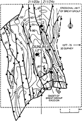
Revision as of 20:42, 14 January 2014 by Importer (talk | contribs) (Structure of the base of the Humber unconformity (top of the Brent Group), Dunlin field, U.K. Northern North Sea mapped with 1979 and 1989 vintage data. Contours are marked in ft subsea × 100; contour interval is 100 ft. (From Braithwaite et al., 1989...)

Size of this preview: 407 × 599 pixels. Other resolutions: 163 × 240 pixels | 936 × 1,378 pixels.
Original file (936 × 1,378 pixels, file size: 102 KB, MIME type: image/png)
Structure of the base of the Humber unconformity (top of the Brent Group), Dunlin field, U.K. Northern North Sea mapped with 1979 and 1989 vintage data. Contours are marked in ft subsea × 100; contour interval is 100 ft. (From Braithwaite et al., 1989.)
File history
Click on a date/time to view the file as it appeared at that time.
| Date/Time | Thumbnail | Dimensions | User | Comment | |
|---|---|---|---|---|---|
| current | 20:42, 14 January 2014 | | 936 × 1,378 (102 KB) | Importer (talk | contribs) | Structure of the base of the Humber unconformity (top of the Brent Group), Dunlin field, U.K. Northern North Sea mapped with 1979 and 1989 vintage data. Contours are marked in ft subsea × 100; contour interval is 100 ft. (From Braithwaite et al., 1989... |
You cannot overwrite this file.
File usage
The following page uses this file: