Difference between revisions of "Growth fault"
Jump to navigation
Jump to search

FWhitehurst (talk | contribs) |
FWhitehurst (talk | contribs) |
||
| Line 1: | Line 1: | ||
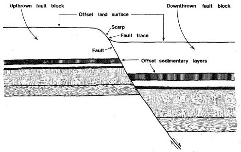
[[File:GrowthFaultFig8.jpg|thumb|500px|Figure 1. Vertical section through a hypothetical fault in the Houston area. Land surface was originally level, but has since been displaced by movement along the fault. Note thickening of sedimentary layers on the downthrown side. This indicates that faulting occurred repeatedly over a long period of time, while the sediments were being deposited. Such faults are common in the Texas Gulf Coast. From USGS.<ref name=Verbeek-et-al />]] | [[File:GrowthFaultFig8.jpg|thumb|500px|Figure 1. Vertical section through a hypothetical fault in the Houston area. Land surface was originally level, but has since been displaced by movement along the fault. Note thickening of sedimentary layers on the downthrown side. This indicates that faulting occurred repeatedly over a long period of time, while the sediments were being deposited. Such faults are common in the Texas Gulf Coast. From USGS.<ref name=Verbeek-et-al />]] | ||
| − | A fault along which movement occurs as sediments are deposited on and above the fault scarp. Continued movement and sedimentation over an extended period of time causes the oldest and lowermost sediments to be offset the most and causes the amount of offset to decrease upward within younger deposits (Figure 1). Such faults are common in the Gulf Coast.<ref name=Verbeek-et-al>Verbeek, E. R., K. W. Ratzlaff, and U. S. Clanton, [http://pubs.usgs.gov/mf-maps/mf1136/mf1136/glossary.htm#glossary Faults in Parts of North-Central and Western Houston Metropolitan Area, Texas]. US Geological Survey Miscellaneous Field Studies Map 1136</ref> | + | A fault along which movement occurs as sediments are deposited on and above the fault scarp. Continued movement and sedimentation over an extended period of time causes the oldest and lowermost sediments to be offset the most and causes the amount of offset to decrease upward within younger deposits (Figure 1). Such faults are common in the Gulf Coast.<ref name=Verbeek-et-al>Verbeek, E. R., K. W. Ratzlaff, and U. S. Clanton, 1979, [http://pubs.usgs.gov/mf-maps/mf1136/mf1136/glossary.htm#glossary Faults in Parts of North-Central and Western Houston Metropolitan Area, Texas]. US Geological Survey Miscellaneous Field Studies Map 1136</ref> |
==References== | ==References== | ||
{{reflist}} | {{reflist}} | ||
Revision as of 16:50, 18 July 2014

Figure 1. Vertical section through a hypothetical fault in the Houston area. Land surface was originally level, but has since been displaced by movement along the fault. Note thickening of sedimentary layers on the downthrown side. This indicates that faulting occurred repeatedly over a long period of time, while the sediments were being deposited. Such faults are common in the Texas Gulf Coast. From USGS.[1]
A fault along which movement occurs as sediments are deposited on and above the fault scarp. Continued movement and sedimentation over an extended period of time causes the oldest and lowermost sediments to be offset the most and causes the amount of offset to decrease upward within younger deposits (Figure 1). Such faults are common in the Gulf Coast.[1]
References
- ↑ 1.0 1.1 Verbeek, E. R., K. W. Ratzlaff, and U. S. Clanton, 1979, Faults in Parts of North-Central and Western Houston Metropolitan Area, Texas. US Geological Survey Miscellaneous Field Studies Map 1136