Difference between revisions of "Plate tectonics and basin formation"
Ivana Debora (talk | contribs) (Created page with "Plate tectonics regards the lithosphere broken into plate that are in motion. The plates move relative to another along plate boundaries, sliding upon the underlying asthenosp...") |
Ivana Debora (talk | contribs) |
||
| Line 128: | Line 128: | ||
===Convergent Plate Boundaries=== | ===Convergent Plate Boundaries=== | ||
Convergent plate boundaries are the collisions between tectonic plates. The collisions between tectonic plates can be distinguished into ocean-ocean convergent, ocean-continent convergent, or continent-continent convergent. The character of the boundary depends partly on the type of plates that converge. In ocean-ocean convergent, a plate can move toward another plate, where one plate subducts under the other. While, in ocean-continent convergent, the dense oceanic plate subducts under the continental plate. In continent-continent convergent, the two approaching plate collide and crumple but neither is subducted. | Convergent plate boundaries are the collisions between tectonic plates. The collisions between tectonic plates can be distinguished into ocean-ocean convergent, ocean-continent convergent, or continent-continent convergent. The character of the boundary depends partly on the type of plates that converge. In ocean-ocean convergent, a plate can move toward another plate, where one plate subducts under the other. While, in ocean-continent convergent, the dense oceanic plate subducts under the continental plate. In continent-continent convergent, the two approaching plate collide and crumple but neither is subducted. | ||
| + | [[File:Ocean-ocean.jpg|framed|center|Ocean-Ocean Convergent <ref> http://oceansjsu.com/images/exp5_oceanocean_conv.gif </ref>]] | ||
| + | [[File:Continental-ocean.jpg|framed|center |Ocean-Continent Convergent <ref> http://geology.com/usgs/gold-prospecting/convergent-boundary-and-magma.jpg </ref>]] | ||
| + | [[File:Cont-cont.jpg|framed|center|Continent-Continent Divergent <ref> http://geomaps.wr.usgs.gov/parks/pltec/contvscont289x153.gif </ref>]] | ||
| + | |||
| + | ==The Cause of Plate Motion== | ||
| + | ===Mantle Convection=== | ||
| + | The widely accepted opinion regarding the cause of the plates move at this time is because of the convection currents in the mantle. The heat from the core of the Earth is transferred to the surface of the Earth through the mantle. The heat from the core warms up the liquid rock on mantle that closest to the core, causing the liquid rock to expand and rise toward the crust. The cooler liquid rock near the surface sinks back down toward the core. In doing so, a current of liquid rock is set up flowing toward the surface and back down again. This mantle convection is believed the causes the plates movement. | ||
| + | [[File:Mantle_convection_cell.jpg|framed|center|Mantle Convection <ref> http://research.bpcrc.osu.edu/education/rr/plate_tectonics/mantle_convection_cell.gif | ||
| + | </ref>]] | ||
| + | |||
| + | ===Ridge Push=== | ||
| + | [[File:Ridge_push-slab_push.jpg|framed|right|Ridge Push and Slab Pull Mechanism <ref> http://www.tulane.edu/~sanelson/images/mantleconvect.gif | ||
| + | </ref>]] | ||
| + | Ridge push or sliding plate force is a proposed mechanism for plate motion in plate tectonics. When a plate moves away from a divergent boundary, it cools and thickens. Cooling sea floor subsides as it moves, and this subsidence forms the broad side slopes of the mid-ocean ridge. An even more important slope form on the base of the lithosphere mantle. The mantle thickens as cooling converts asthenospheric mantle to lithospheric mantle. Therefore, the boundary between them is a slope down which the lithosphere slides. The oceanic plate is thought to slide down this slope at the base of lithosphere, which may have a relief of 80 to 1000 kilometres. | ||
| + | |||
| + | ===Slab Pull=== | ||
| + | The other proposal is called slab pull. Cold lithosphere sinking at a steep angle through hot mantle should pull the surface part of the plate away from the ridge crest and then down into mantle as it cools. A subduction plate sinks because it is denser than the surrounding mantle. This density contrast is partly due to the fact that sinking lithosphere is cold. The subduction plate may also increase its density while it sinks, as low-density materials such as water are lost and as plate minerals collapse into denser form during subduction. Slab pull is thought to be at least twice as important as ridge push in moving an oceanic plate away from aridge crest. Slab pull causes rapid plate movement. | ||
| + | |||
| + | ==Continental Drift== | ||
| + | [[File:Continental_drift1.jpg|framed|center|Continental Drift <ref> http://media-1.web.britannica.com/eb-media/99/101699-004-066A8D00.jpg </ref>]] | ||
| + | The revolution in the science of earth has been started since the early 19th century, when the emergence of a radical thought at that time to propose a hypothesis about the continents that move on the surface of the earth. Actually, the theory of plate tectonics already emerged when the idea of the Flotation hypothesis Continent (Continental Drift) was introduced first time by Alfred Wegener (1915) in his book "The Origins of Oceans and Continents". An effect of this floatation continent hypothesis is a hypothesis which assumes that the continents that exist today united formerly known as the super-continent called Pangaea. This super-continent Pangaea allegedly formed 200 million years ago which was then fragmented into pieces smaller then migrate or drifted into position as it is today. | ||
| + | |||
| + | Proof of the existence of the super-continent Pangaea 200 million years ago supported by the facts as follows: | ||
| + | ===The similarity of shorelines=== | ||
| + | The lack of compatibility coastline in the eastern part of the South American continent with a coastline of the western part of the African continent. Both this coastline when matched to one another will coincide. Wegener suspected that both continents were originally one. Based on the lack of compatibility shape of the coastline was then Wegener tried to match all the continents on earth. | ||
| + | ===The discovery of fossils from animals and plants are widespread and separated on several continents=== | ||
| + | * Cynognathus fossil, a reptile that lived about 240 million years ago and was found in the South American continent and the African continent. | ||
| + | * Mesosaurus fossil, a reptile that lived in freshwater lakes and rivers that lived about 260 million years ago, was found in the South American continent and the African continent. | ||
| + | * Lystrosaurus fossil, a reptile that lived on land around 240 million years ago, was found in the continent of Africa, India and Antarctica. | ||
| + | * Clossopteris fossils, a plant that lived 260 million years ago, was found in the continent of Africa, South America, India, Australia, and Antarctica. | ||
| + | ===The evidence of ancient climate=== | ||
| + | Earth scientist has also been studying the ancient climate, where in 250 million years ago was known that the southern hemisphere at the time it happened a cold climate, where the southern hemisphere was covered by a very thick layer of ice, such as in Antarctica, Australia, South America, Africa, and India. The areas that affected by glaciation in mainland Africa turned constantly to the equatorial region. However, this argument was later rejected, because for a period of glaciation in the southern hemisphere, the northern hemisphere tropical climates was characterized by the development of tropical swamp forests were extremely widespread and was the origin of the coal deposits in America eastern, Europe and Asia. | ||
| + | At this time, experts believe that the new terrestrial land experiencing glaciation came from the mainland, known as the super-continent Pangaea that located deep in the southern part of the current position. The evidence of Wegener to support the hypothesis of continental drift that newly acquired after 50 years of prior public geoscientists believe the truth of the hypothesis of continental drift. | ||
| + | ===The similarity of rock type=== | ||
| + | The Appalachian mountain path are located in the eastern part of the North American continent with the spread trending northeast and suddenly disappear on the beach Newfoundlands. Mountains that has a same age with the Appalachian mountains are also found in the British Isles and Scandinavia. Both of these mountains would form a continuous mountain paths. By way of uniting or matching the appearance of geological forms that separated by an ocean is needed, but the data are not sufficient to prove the hypothesis of a continental drift. In other words, if a continent has experienced separation from one another, it is absolutely necessary evidence that the geological structure and rock types is suitable or appropriate. Although the evidence of geological appearance is matched between the continents, but it is not enough to prove that the continent has undergone floatation. | ||
| + | |||
| + | =Basin Formation= | ||
| + | One of the geologic events can be explained by the theory of plate tectonics was the formation of basin. | ||
| + | |||
| + | ==What's Basin?== | ||
| + | Basin in geology is defined as a low area in the Earth’s crust, of tectonic origin, in which sediments accumulate. Basins range in size from as small as hundreds of meters to large parts of ocean basins. | ||
| + | |||
| + | How basin can be created? On some cases with a small scale, fault movements can create relief of hundreds to thousands of meters laterally, resulting in small but often deep basins. But, the other main reason is because the continent rift. In plate tectonic theory, if one of plates rifting into pieces diverging apart then new basins being born, followed by motion reversal, convergence back together, plate collision, and mountain building. | ||
=Reference= | =Reference= | ||
<references /> | <references /> | ||
Revision as of 15:40, 30 June 2015
Plate tectonics regards the lithosphere broken into plate that are in motion. The plates move relative to another along plate boundaries, sliding upon the underlying asthenosphere (the layer below the lithosphere that is formed of molten rock). The theory of plate tectonics emerged since the 1960s, and until now this theory has successfully explained various geological events, such as earthquakes, tsunamis, and volcanic eruption, also explained how the formation of mountains, continents, and oceans.

List of Tectonic Plates [2]
The lithosphere is divided into several tectonic plates intersect with each other. Here are the names of tectonic plates on the Earth:
Major Plates (≥10 million km2)
These ten plates comprise the bulk of the continents and the Pacific Ocean.
- Pacific Plate – 103,300,000 km2
- North American Plate – 75,900,000 km2
- Eurasian Plate – 67,800,000 km2
- African Plate – 61,300,000 km2
- Antarctic Plate – 60,900,000 km2
- Australian Plate – 47,000,000 km2
- South American Plate – 43,600,000 km2
- Somali Plate – 16,700,000 km2
- Nazca Plate – 15,600,000 km2
- Indian Plate – 11,900,000 km2
Minor Plates (≥ 1 million km2, ≤ 10 million km2)
- Philippine Sea Plate – 5,500,000 km2
- Arabian Plate – 5,000,000 km2
- Caribbean Plate – 3,300,000 km2
- Cocos Plate – 2,900,000 km2
- Caroline Plate – 1,700,000 km2
- Scotia Plate – 1,600,000 km2
- Burma Plate – 1,100,000 km2
- New Hebrides Plate – 1,100,000 km2
Micro Plates (≤ 1 million km2)
African Plate
- Lwandle Plate
- Rovuma Plate
- Seychelles Plate
- Victoria Plate
Antarctic Plate
- Kerguelen microcontinent
- Shetland Plate
- South Sandwich Plate
Caribbean Plate
- Panama Plate
- Gonâve Microplate
Cocos Plate
- Rivera Plate
Eurasian Plate
- Adriatic or Apulian Plate
- Aegean Sea Plate (or Hellenic Plate)
- Amurian Plate
- Anatolian Plate
- Azores Microplate[5]
- Banda Sea Plate
- Iberian Plate
- Iranian Plate
- Molucca Sea Plate
- Halmahera Plate
- Sangihe Plate
- Okinawa Plate
- Pelso Plate
- Sunda Plate
- Timor Plate
- Tisza Plate
- Yangtze Plate
Australian Plate
- Capricorn Plate
- Futuna Plate
- Indian Plate
- Kermadec Plate
- Maoke Plate
- Niuafo'ou Plate
- Sri Lanka Plate
- Tonga Plate
- Woodlark Plate
Juan de Fuca Plate
- Explorer Plate
- Gorda Plate
North American Plate
- Greenland Plate
- Okhotsk Plate
Pacific Plate
- Balmoral Reef Plate
- Bird's Head Plate
- Caroline Plate
- Conway Reef Plate
- Easter Plate
- Galapagos Plate
- Juan Fernandez Plate
- Kula Plate
- Manus Plate
- New Hebrides Plate
- North Bismarck Plate
- North Galapagos MicroPlate
- Solomon Sea Plate
- South Bismarck Plate
Philippine Sea Plate
- Mariana Plate
- Philippine Microplate
South American Plate
- Altiplano Plate
- Falklands Microplate
- North Andes Plate
Plate Movements
The tectonic plates of the earth is not stationary, but moves relative with the speed of 1 to 10 cm per year. The movement of the earth's crustal plates that collide with each other will form the subduction zone and cause the forces acting both horizontally and vertically, which will form the folds of the mountains, volcanoes track or magmatic, fracturing the rock, and the lines of tectonic earthquakes and the formation of a particular region. Moreover, that will also form various types of deposition of sedimentary basins such as trench, fore arc basin, back arc basin, and basin between the mountains.
Plate Boundaries
Based on the direction of its movement, the plate boundary between tectonic plates with the other plate boundaries are divided into three types.
Divergent Plate Boundaries
Divergent plate boundaries occurs on two tectonic plates are break apart. When a broken plate tectonics, lithospheric thinning layer and split, forming divergent boundaries. In the ocean plate, this process causes the seafloor spreading. While on the continental shelf, this process causes the formation of rift valley due to the gap between the two plates which are away from each other. Mid-Atlantic Ridge is one of the most famous examples of divergent, stretching from north to south along the Atlantic Ocean, restricting the Continent of Europe and Africa to the Americas.

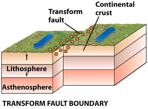
Transform Boundaries
At transform boundaries, one plate slides horizontally past another plate, the plate can occur on a single fault or on a group of parallel faults. Transform boundary is also known as transform fault. The most common type of transform fault occurs along fracture zones and connect two divergent plate boundaries at the crest of the mid-oceanic ridge. The example of transform boundaries is the friction between the plates of the Pacific Ocean to the North American mainland plate which resulted the formation of the San Andreas Fault which extends along approximately 1,200 km from San Francisco in the north to the south of Los Angeles in the United States.
Convergent Plate Boundaries
Convergent plate boundaries are the collisions between tectonic plates. The collisions between tectonic plates can be distinguished into ocean-ocean convergent, ocean-continent convergent, or continent-continent convergent. The character of the boundary depends partly on the type of plates that converge. In ocean-ocean convergent, a plate can move toward another plate, where one plate subducts under the other. While, in ocean-continent convergent, the dense oceanic plate subducts under the continental plate. In continent-continent convergent, the two approaching plate collide and crumple but neither is subducted.


The Cause of Plate Motion
Mantle Convection
The widely accepted opinion regarding the cause of the plates move at this time is because of the convection currents in the mantle. The heat from the core of the Earth is transferred to the surface of the Earth through the mantle. The heat from the core warms up the liquid rock on mantle that closest to the core, causing the liquid rock to expand and rise toward the crust. The cooler liquid rock near the surface sinks back down toward the core. In doing so, a current of liquid rock is set up flowing toward the surface and back down again. This mantle convection is believed the causes the plates movement.

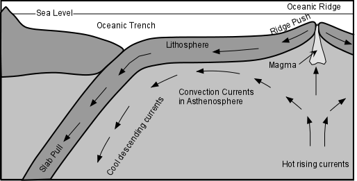
Ridge Push

Ridge push or sliding plate force is a proposed mechanism for plate motion in plate tectonics. When a plate moves away from a divergent boundary, it cools and thickens. Cooling sea floor subsides as it moves, and this subsidence forms the broad side slopes of the mid-ocean ridge. An even more important slope form on the base of the lithosphere mantle. The mantle thickens as cooling converts asthenospheric mantle to lithospheric mantle. Therefore, the boundary between them is a slope down which the lithosphere slides. The oceanic plate is thought to slide down this slope at the base of lithosphere, which may have a relief of 80 to 1000 kilometres.
Slab Pull
The other proposal is called slab pull. Cold lithosphere sinking at a steep angle through hot mantle should pull the surface part of the plate away from the ridge crest and then down into mantle as it cools. A subduction plate sinks because it is denser than the surrounding mantle. This density contrast is partly due to the fact that sinking lithosphere is cold. The subduction plate may also increase its density while it sinks, as low-density materials such as water are lost and as plate minerals collapse into denser form during subduction. Slab pull is thought to be at least twice as important as ridge push in moving an oceanic plate away from aridge crest. Slab pull causes rapid plate movement.
Continental Drift

The revolution in the science of earth has been started since the early 19th century, when the emergence of a radical thought at that time to propose a hypothesis about the continents that move on the surface of the earth. Actually, the theory of plate tectonics already emerged when the idea of the Flotation hypothesis Continent (Continental Drift) was introduced first time by Alfred Wegener (1915) in his book "The Origins of Oceans and Continents". An effect of this floatation continent hypothesis is a hypothesis which assumes that the continents that exist today united formerly known as the super-continent called Pangaea. This super-continent Pangaea allegedly formed 200 million years ago which was then fragmented into pieces smaller then migrate or drifted into position as it is today.
Proof of the existence of the super-continent Pangaea 200 million years ago supported by the facts as follows:
The similarity of shorelines
The lack of compatibility coastline in the eastern part of the South American continent with a coastline of the western part of the African continent. Both this coastline when matched to one another will coincide. Wegener suspected that both continents were originally one. Based on the lack of compatibility shape of the coastline was then Wegener tried to match all the continents on earth.
The discovery of fossils from animals and plants are widespread and separated on several continents
- Cynognathus fossil, a reptile that lived about 240 million years ago and was found in the South American continent and the African continent.
- Mesosaurus fossil, a reptile that lived in freshwater lakes and rivers that lived about 260 million years ago, was found in the South American continent and the African continent.
- Lystrosaurus fossil, a reptile that lived on land around 240 million years ago, was found in the continent of Africa, India and Antarctica.
- Clossopteris fossils, a plant that lived 260 million years ago, was found in the continent of Africa, South America, India, Australia, and Antarctica.
The evidence of ancient climate
Earth scientist has also been studying the ancient climate, where in 250 million years ago was known that the southern hemisphere at the time it happened a cold climate, where the southern hemisphere was covered by a very thick layer of ice, such as in Antarctica, Australia, South America, Africa, and India. The areas that affected by glaciation in mainland Africa turned constantly to the equatorial region. However, this argument was later rejected, because for a period of glaciation in the southern hemisphere, the northern hemisphere tropical climates was characterized by the development of tropical swamp forests were extremely widespread and was the origin of the coal deposits in America eastern, Europe and Asia. At this time, experts believe that the new terrestrial land experiencing glaciation came from the mainland, known as the super-continent Pangaea that located deep in the southern part of the current position. The evidence of Wegener to support the hypothesis of continental drift that newly acquired after 50 years of prior public geoscientists believe the truth of the hypothesis of continental drift.
The similarity of rock type
The Appalachian mountain path are located in the eastern part of the North American continent with the spread trending northeast and suddenly disappear on the beach Newfoundlands. Mountains that has a same age with the Appalachian mountains are also found in the British Isles and Scandinavia. Both of these mountains would form a continuous mountain paths. By way of uniting or matching the appearance of geological forms that separated by an ocean is needed, but the data are not sufficient to prove the hypothesis of a continental drift. In other words, if a continent has experienced separation from one another, it is absolutely necessary evidence that the geological structure and rock types is suitable or appropriate. Although the evidence of geological appearance is matched between the continents, but it is not enough to prove that the continent has undergone floatation.
Basin Formation
One of the geologic events can be explained by the theory of plate tectonics was the formation of basin.
What's Basin?
Basin in geology is defined as a low area in the Earth’s crust, of tectonic origin, in which sediments accumulate. Basins range in size from as small as hundreds of meters to large parts of ocean basins.
How basin can be created? On some cases with a small scale, fault movements can create relief of hundreds to thousands of meters laterally, resulting in small but often deep basins. But, the other main reason is because the continent rift. In plate tectonic theory, if one of plates rifting into pieces diverging apart then new basins being born, followed by motion reversal, convergence back together, plate collision, and mountain building.
Reference
- ↑ http:http://earthobservatory.nasa.gov/Features/Tectonics/Images/schematic_map.gif
- ↑ https://en.wikipedia.org/wiki/List_of_tectonic_plates
- ↑ http://science7soham.weebly.com/uploads/2/3/3/3/23339682/3633292_orig.jpg
- ↑ http://academic.brooklyn.cuny.edu/geology/grocha/plates/images/transform1.jpg
- ↑ http://oceansjsu.com/images/exp5_oceanocean_conv.gif
- ↑ http://geology.com/usgs/gold-prospecting/convergent-boundary-and-magma.jpg
- ↑ http://geomaps.wr.usgs.gov/parks/pltec/contvscont289x153.gif
- ↑ http://research.bpcrc.osu.edu/education/rr/plate_tectonics/mantle_convection_cell.gif
- ↑ http://www.tulane.edu/~sanelson/images/mantleconvect.gif
- ↑ http://media-1.web.britannica.com/eb-media/99/101699-004-066A8D00.jpg