Search results
Jump to navigation
Jump to search
Page title matches
- ...cuna 3-D seismic survey ([[:File:Methods14ch08f01.jpg|Figure 1]]), Arecuna field contains an estimated 2.8 billion barrels of original oil in place, but to ==Geologic architecture of the Arecuna field==16 KB (2,381 words) - 19:03, 11 March 2019
- ...Reservoir Geology of the Upper Jurassic Brae Sandstone Member, Kingfisher Field, South Viking Graben, U.K. North Sea ...55–62.</ref><ref name=Fletcher2003b>Fletcher, K. J., 2003b, The South Brae Field, Blocks 16/07a, 16/07b, UK North Sea, in J. G. Gluyas and H. M. Hichens, ed16 KB (2,358 words) - 16:28, 11 January 2024
- | chapter = A Depositional Model for the T-Block Thelma Field, UKCS Block 16/17 ...form. A total of seven producers have been drilled across the whole Thelma field area ([[:file:M115CH11FG02.jpg|Figure 2]]), with four wells dominating prod17 KB (2,614 words) - 19:14, 17 January 2022
- Wattenberg field | chapter = Field Growth in the Supergiant Wattenberg Field, Denver Basin, Colorado, USA72 KB (10,249 words) - 20:06, 15 January 2024
- ...ent uplift; WF = Waterpocket fold; A = Absaroka thrust fault. (c) Covenant field locality map of central Utah. From Parry, et. al<ref name=Parry />]] ...hitecture, petroleum systems, and geological implications for the Covenant field discovery, Sevier County, Utah]: AAPG Search and Discovery Article No. 11006 KB (897 words) - 19:39, 14 February 2017
- | title = Pinedale Field: Case Study of a Giant Tight Gas Sandstone Reservoir | chapter = The Significance of the Pinedale Field16 KB (2,521 words) - 17:13, 29 January 2016
- ...turbidite reservoir: The ARCO-DOE 91X-3 horizontal well project, Yowlumne field, San Juaquin Basin, California Yowlumne is a giant oil field in the San Joaquin Basin, California ([[:file:Mth14ch02f01.jpg|Figure 1]]),13 KB (1,896 words) - 19:02, 11 March 2019
- ...nd conclusions of a horizontal-drilling program at South Pass 62 salt-dome field Prudhoe Bay field lies on the Alaska coastal plain between Naval Petroleum Reserve No. 4 (NPR11 KB (1,634 words) - 16:34, 26 April 2016
- 3 KB (412 words) - 22:40, 1 February 2022

File:Oil-field-production-geology.png (450 × 633 (553 KB)) - 18:24, 7 April 2014- #REDIRECT [[Magnetic field: local variations]]46 bytes (5 words) - 21:19, 14 May 2014
- Variations in the local magnetic field are due mainly to the following: ...urves above the cross section are the magnetic profiles where the magnetic field is vertical for ''k''<sub>1</sub> > ''k''<sub>2</sub> and ''k''<sub>1</sub>6 KB (946 words) - 19:56, 27 January 2022
- ...ter contacts and apparent anomalies in saturation profiles in the Sorrento field are due to multiple flow units from two separate reservoirs. This example u ...as Fields, p. 305–328.</ref> Reliably recognizing separate reservoirs in a field requires considering [[capillary pressure]]s, [[Free water level|heights ab7 KB (1,044 words) - 16:57, 13 April 2022
- ...nd conclusions of a horizontal-drilling program at South Pass 62 salt-dome field ....jpg|Figure 2]], [[:file:Mth14ch04f03.jpg|Figure 3]]). A 3-D seismic-based field study completed in 1994 identified reservoir targets for the horizontal-dri9 KB (1,290 words) - 21:18, 19 October 2016
- #REDIRECT [[Sorrento field: water saturation]]46 bytes (5 words) - 16:15, 21 November 2014
- ...ts and not necessarily in response to structural [[dip]]. Gas in the Beryl field, for example, migrated downdip during production in response to changing pr ==Fault seal and field unitization==3 KB (479 words) - 15:21, 30 March 2022
- ...name=ch09r9>Chetin, A. K., and W. W. Fitkin, 1959, Geology of the Weyburn field, Saskatchewan: Canadian Mining and Metallurgical Bulletin, December, p. 751 ...erformance_fig9-96.png|Figure 1]] is a map showing the location of Weyburn field.6 KB (848 words) - 17:34, 3 January 2024
- #REDIRECT [[Sorrento field: water saturation]]46 bytes (5 words) - 16:16, 21 November 2014
- #REDIRECT [[Sediment thickness and field location maps: Gulf of Mexico example]]80 bytes (11 words) - 21:04, 19 December 2014
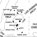
- ...., and E. B. Coalson, 1990, Evaluation of the Morrow sandstone in Sorrento field, Cheyenne County, Colorado, ''in'' S. A. Sonnenberg, L. T. Shannon, K. Rade * [[Setting and structure of the Sorrento field]]7 KB (956 words) - 17:24, 11 April 2022
- ...Tectonic and sedimentation model for Morrow sandstone deposition, Sorrento field area, Denver basin, Colorado: The Mountain Geologist, October, p. 180-191.< ...-and-performance_fig9-85.png|Figure 1]] shows the location of the Sorrento field. Structure is contoured on the base of the Pennsylvanian.3 KB (429 words) - 14:19, 11 April 2022
- ...Tectonic and sedimentation model for Morrow sandstone deposition, Sorrento field area, Denver basin, Colorado: The Mountain Geologist, October, p. 180-191.< Morrow sandstones in the Sorrento field are slightly shaly, range in [[grain size]] from very coarse to fine, and a6 KB (769 words) - 17:23, 11 April 2022
- 5 KB (753 words) - 19:58, 18 February 2022
- Planning and logistics are key components for the success of any field party. An important pre-field step is to review previous work. This includes finding and evaluating previ5 KB (730 words) - 22:36, 1 February 2022

Page text matches
File:MainPageSorrentoField.png ...: Sorrento field; Petrophysical analysis of Sorrento field wells; Sorrento field: water saturation.(400 × 400 (43 KB)) - 17:53, 5 January 2015
File:BasinCenteredGasFig4.jpg ...Relief on top of overpressuring from outside the field area to inside the field area ranges from 2500 to 3000 ft (762-914 m) (Warner, 1998). Figure modifie(600 × 783 (79 KB)) - 22:22, 13 January 2015
File:M91Figure165.JPG ...printed with permission from the Geological Society in AAPG Memoir 91, Oil field petroleum geology, by Mike Shepherd.(800 × 881 (128 KB)) - 20:28, 30 July 2014- | image = Oil-field-production-geology.png | title = Oil Field Production Geology1 member (0 subcategories, 0 files) - 17:33, 13 April 2022
File:M115CH10FG03.jpg ...ingfisher field 15 km (9 mi) to the northeast. Modified after [[Kingfisher field|Turner et al. (1987]]). From AAPG Memoir 115—Rift-Related Coarse-Grained(1,076 × 597 (435 KB)) - 18:42, 17 January 2019
File:M91Ch6FG42.JPG ...slow, 1999). From Shepherd, M., 2009, Sources of data, in M. Shepherd, Oil field production geology: AAPG Memoir 91, p. 49-63.(800 × 942 (95 KB)) - 17:04, 3 June 2015
File:M91Ch6FG47.JPG ...cal Society. From Shepherd, M., 2009, Sources of data, in M. Shepherd, Oil field production geology: AAPG Memoir 91, p. 49-63.(600 × 758 (111 KB)) - 21:46, 29 April 2015
File:M91Figure164.JPG ...h et al., 1998). Reprinted with permission from the AAPG in Memoir 91, Oil field petroleum geology, by Mike Shepherd.(800 × 483 (64 KB)) - 20:19, 30 July 2014
File:M91FG188.JPG ...amma ray. From Shepherd, M., 2009, Deltaic reservoirs, in M. Shepherd, Oil field production geology: AAPG Memoir 91, p. 279-288.(800 × 385 (54 KB)) - 16:21, 20 August 2015
File:M91Ch11FG73.JPG ...al Society. From Shepherd, M., 2009, Lithofacies maps, in M. Shepherd, Oil field production geology: AAPG Memoir 91, p. 93-98.(800 × 738 (128 KB)) - 15:54, 27 April 2015
File:M91FG179.JPG ...rom Shepherd, M., 2009, Meandering fluvial reservoirs, in M. Shepherd, Oil field production geology: AAPG Memoir 91, p. 261-272.(800 × 984 (103 KB)) - 21:50, 3 August 2015
File:M91FG183.JPG .... From Shepherd, M., 2009, Braided fluvial reservoirs, in M. Shepherd, Oil field production geology: AAPG Memoir 91, p. 273-277.(800 × 1,199 (103 KB)) - 19:00, 12 August 2015
File:M91FG177.JPG ...rom Shepherd, M., 2009, Meandering fluvial reservoirs, in M. Shepherd, Oil field production geology: AAPG Memoir 91, p. 261-272.(800 × 765 (56 KB)) - 21:21, 3 August 2015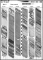
File:M91Ch6FG41.JPG ...y of London. From Shepherd, M., 2009, Sources of data, in M. Shepherd, Oil field production geology: AAPG Memoir 91, p. 49-63.(600 × 835 (138 KB)) - 17:00, 3 June 2015
File:M91FG117.JPG ...forms are fairways for water ingress. Tidal mud flat deposits south of the field restrict water influx from this direction (from Tyler and Ambrose, 1986). R(800 × 689 (66 KB)) - 21:32, 12 August 2015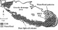
File:Mth14ch07f05.jpg ...ique Horizontal-well Designs Boost Primary and EOR Production, Prudhoe Bay Field, Alaska , by R. S. Tye, B. A. Watson, P. L. McGuire, and M. M. Maguire, Pag(500 × 264 (41 KB)) - 18:09, 7 December 2015
File:M91Ch6FG43.JPG ...further use. From Shepherd, M., 2009, Sources of data, in M. Shepherd, Oil field production geology: AAPG Memoir 91, p. 49-63.(800 × 827 (107 KB)) - 17:07, 3 June 2015
File:M115CH10FG04.jpg ...isher field. Also shown are the BP genetic sequences based on [[Kingfisher field|Partington et al. (1993)]]. From AAPG Memoir 115—Rift-Related Coarse-Grai(1,266 × 845 (845 KB)) - 18:43, 17 January 2019
File:M91Ch11FG69.JPG ...oil field. From Shepherd, M., 2009, Lithofacies maps, in M. Shepherd, Oil field production geology: AAPG Memoir 91, p. 93-98.(600 × 606 (106 KB)) - 15:42, 27 April 2015
File:M91FG190.JPG ...the AAPG. From Shepherd, M., 2009, Deltaic reservoirs, in M. Shepherd, Oil field production geology: AAPG Memoir 91, p. 279-288.(800 × 1,047 (162 KB)) - 18:05, 20 August 2015- #REDIRECT [[Sorrento field: water saturation]]46 bytes (5 words) - 16:15, 21 November 2014
- #REDIRECT [[Sorrento field: water saturation]]46 bytes (5 words) - 16:17, 21 November 2014
- #REDIRECT [[Sorrento field: water saturation]]46 bytes (5 words) - 16:16, 21 November 2014
- #REDIRECT [[Magnetic field: local variations]]46 bytes (5 words) - 21:19, 14 May 2014
- ...-field) measurement. The E-field is always measured perpendicular to the H-field data. ==The H-field==4 KB (519 words) - 19:57, 27 January 2022
File:Mth14ch04f02.jpg ...nd Conclusions of a Horizontal-drilling Program at South Pass 62 Salt-dome Field, by E. P. Mason, M. J. Bastian, R. Detomo, M. N. Hashem, and A. J. Hildebra(500 × 718 (88 KB)) - 16:08, 7 December 2015
File:M91Ch11FG72.JPG ...= gamma-ray log. Shepherd, M., 2009, Lithofacies maps, in M. Shepherd, Oil field production geology: AAPG Memoir 91, p. 93-98.(800 × 658 (69 KB)) - 15:51, 27 April 2015- #REDIRECT [[Morrow lithofacies and pore types: Sorrento field]]63 bytes (8 words) - 12:35, 4 June 2014
File:Mth14ch07f01.jpg ...ique Horizontal-well Designs Boost Primary and EOR Production, Prudhoe Bay Field, Alaska , by R. S. Tye, B. A. Watson, P. L. McGuire, and M. M. Maguire, Pag(700 × 809 (135 KB)) - 17:34, 7 December 2015
File:M91FG184.JPG ...rom AAPG. From Shepherd, M., 2009, Deltaic reservoirs, in M. Shepherd, Oil field production geology: AAPG Memoir 91, p. 279-288.(800 × 1,134 (191 KB)) - 20:10, 12 August 2015- #REDIRECT [[Sediment thickness and field location maps: Gulf of Mexico example]]80 bytes (11 words) - 21:04, 19 December 2014
File:M91Ch13FG92.JPG .... From Shepherd, M., 2009, Structural geology: Faults, in M. Shepherd, Oil field production geology: AAPG Memoir 91, p. 107-122.(600 × 517 (60 KB)) - 21:40, 29 April 2015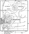
File:BasinCenteredGasFig14.jpg ...Sandstone in the Wattenburg field (modified from Higley et al., 1992). The field is nearly coincident with the 0.9% isoreflectance contour (Higley et al., 1(400 × 478 (53 KB)) - 16:30, 11 March 2015
File:M91Ch11FG71.JPG ...al., 2002). From Shepherd, M., 2009, Lithofacies maps, in M. Shepherd, Oil field production geology: AAPG Memoir 91, p. 93-98.(800 × 629 (79 KB)) - 15:48, 27 April 2015
File:Core-log-transformations-and-porosity-permeability-relationships fig5.png ...permeability (run under stress) versus helium porosity from McArthur River Field, Alaska.(912 × 1,127 (19 KB)) - 18:06, 14 January 2014
File:Mth14ch07f02.jpg ...ique Horizontal-well Designs Boost Primary and EOR Production, Prudhoe Bay Field, Alaska , by R. S. Tye, B. A. Watson, P. L. McGuire, and M. M. Maguire, Pag(500 × 923 (106 KB)) - 17:50, 7 December 2015
File:Mth14ch04f03.jpg ...nd Conclusions of a Horizontal-drilling Program at South Pass 62 Salt-dome Field, by E. P. Mason, M. J. Bastian, R. Detomo, M. N. Hashem, and A. J. Hildebra(500 × 495 (47 KB)) - 16:09, 7 December 2015
File:M91Ch13FG84.JPG .... From Shepherd, M., 2009, Structural geology: Faults, in M. Shepherd, Oil field production geology: AAPG Memoir 91, p. 107-122.(600 × 766 (134 KB)) - 21:34, 29 April 2015
File:Mth14ch02f03.jpg ...Turbidite Reservoir--The ARCO-DOE 91X-3 Horizontal Well Project, Yowlumne Field, San Joaquin Basin, California in AAPG Methods in Exploration No. 14: Horiz(700 × 529 (75 KB)) - 15:26, 4 December 2015
File:Mth14ch02f08.jpg ...Turbidite Reservoir--The ARCO-DOE 91X-3 Horizontal Well Project, Yowlumne Field, San Joaquin Basin, California in AAPG Methods in Exploration No. 14: Horiz(400 × 465 (28 KB)) - 20:19, 4 December 2015
File:Mth14ch04f06.jpg ...nd Conclusions of a Horizontal-drilling Program at South Pass 62 Salt-dome Field, by E. P. Mason, M. J. Bastian, R. Detomo, M. N. Hashem, and A. J. Hildebra(800 × 563 (141 KB)) - 16:55, 7 December 2015
File:Paleontology fig3.png Correlation of Rodessa Formation lithofacies at Running Duke Field, Houston County, Texas. Cores are indicated by solid vertical lines. (From(1,973 × 1,229 (190 KB)) - 17:38, 14 January 2014
File:Conducting-a-reservoir-simulation-study-an-overview fig3.png Model grid overlain on Khursaniyah field, Saudi Arabia. (From Boberg, 1974; Copyright © 1974 Society of Petroleum E(926 × 1,188 (30 KB)) - 18:46, 14 January 2014
File:Mth14ch04f05.jpg ...nd Conclusions of a Horizontal-drilling Program at South Pass 62 Salt-dome Field, by E. P. Mason, M. J. Bastian, R. Detomo, M. N. Hashem, and A. J. Hildebra(700 × 469 (63 KB)) - 16:53, 7 December 2015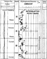
File:Dipmeters fig7.png Field example of a detailed dip computation through a sequence of interrupted mea(955 × 1,189 (73 KB)) - 01:19, 14 January 2014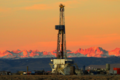
File:PinedaleFieldLandRig.png Drilling rig in Pinedale field with the Wind River Mountains, Wyoming, USA in the background. Photo by Dou(600 × 400 (426 KB)) - 21:00, 14 March 2014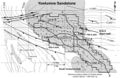
File:Mth14ch02f01.jpg ...Turbidite Reservoir--The ARCO-DOE 91X-3 Horizontal Well Project, Yowlumne Field, San Joaquin Basin, California in AAPG Methods in Exploration No. 14: Horiz(700 × 457 (103 KB)) - 23:18, 3 December 2015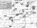
File:Mth14ch04f01.jpg ...nd Conclusions of a Horizontal-drilling Program at South Pass 62 Salt-dome Field, by E. P. Mason, M. J. Bastian, R. Detomo, M. N. Hashem, and A. J. Hildebra(700 × 525 (111 KB)) - 16:00, 7 December 2015
File:Mthch02f02.jpg ...Turbidite Reservoir--The ARCO-DOE 91X-3 Horizontal Well Project, Yowlumne Field, San Joaquin Basin, California in AAPG Methods in Exploration No. 14: Horiz(300 × 453 (36 KB)) - 15:19, 4 December 2015
File:Subsurface-maps fig4.png (a) Cross section and (b) net pay Isopach map of the Strachan gas field, western Canada. Contour Interval is 100 ft. (From Hriskevich et al., 1980.(890 × 1,386 (78 KB)) - 20:42, 14 January 2014
File:M91Ch6FG40.JPG ...on display. From Shepherd, M., 2009, Sources of data, in M. Shepherd, Oil field production geology: AAPG Memoir 91, p. 49-63.(600 × 402 (45 KB)) - 16:55, 3 June 2015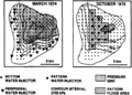
File:Subsurface-maps fig3.png Map of pressure response to pattern flood, Judy Creek field, western Canada, 1974 and 1975. Contour interval is 2750 kPa. (After Jardin(931 × 665 (79 KB)) - 20:42, 14 January 2014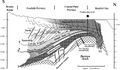
File:Mth14ch07f03.jpg ...ique Horizontal-well Designs Boost Primary and EOR Production, Prudhoe Bay Field, Alaska , by R. S. Tye, B. A. Watson, P. L. McGuire, and M. M. Maguire, Pag(700 × 409 (77 KB)) - 17:55, 7 December 2015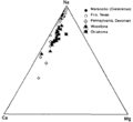
File:Oilfield-water-analysis fig1.png Triangular plot showing relative amounts of cations in typical oil field brines. Relative amount of sodium changes, but calcium is always about five(896 × 824 (10 KB)) - 17:24, 14 January 2014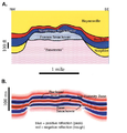
File:Reef1.png ...modeling of Figure 7 and (B) seismic section of the structure at Appleton field (modified from Balch and Hart, 2000).(471 × 491 (248 KB)) - 16:08, 20 November 2014
File:M115CH11FG03.jpg Summary of the “Brae Play” ([[Thelma field|Fraser et al., 2003]]). From AAPG Memoir 115—Rift-Related Coarse-Grained(1,283 × 870 (408 KB)) - 15:13, 22 January 2019
File:M91FG175.JPG ...rom Shepherd, M., 2009, Meandering fluvial reservoirs, in M. Shepherd, Oil field production geology: AAPG Memoir 91, p. 261-272.(800 × 520 (107 KB)) - 19:54, 3 August 2015
File:M91FG170.JPG ...ironments. From Shepherd, M., 2009, Eolian reservoirs, in M. Shepherd, Oil field production geology: AAPG Memoir 91, p. 255-259.(800 × 670 (90 KB)) - 17:03, 29 July 2015
File:M91FG171.JPG ...ents. From From Shepherd, M., 2009, Eolian reservoirs, in M. Shepherd, Oil field production geology: AAPG Memoir 91, p. 255-259.(800 × 734 (138 KB)) - 17:18, 29 July 2015
File:Subsurface-maps fig6.png ...maps for the B and C zones from the San Andres Formation reservoir, Jordan field, Ector and Crane Counties, Texas. Contours in PV fraction-feet. (After Majo(1,944 × 1,484 (237 KB)) - 20:42, 14 January 2014
File:M91FG176.JPG ...rom Shepherd, M., 2009, Meandering fluvial reservoirs, in M. Shepherd, Oil field production geology: AAPG Memoir 91, p. 261-272.(800 × 929 (161 KB)) - 20:28, 3 August 2015
File:Evaluating-diagenetically-complex-reservoirs fig1.png Cross section in the Crane Field, Richland County, Montana, showing extreme irregularities in the developmen(952 × 409 (46 KB)) - 18:46, 14 January 2014
File:Subsurface-maps fig7.png ...r the A, B, C, and D zones from the San Andres Formation reservoir, Jordan field, Ector and Crane counties, Texas. Contours in MSTB/year/acre. (After Major(944 × 1,353 (62 KB)) - 20:42, 14 January 2014
File:M91Ch6FG48.JPG ...urther use). From Shepherd, M., 2009, Sources of data, in M. Shepherd, Oil field production geology: AAPG Memoir 91, p. 49-63.(600 × 428 (145 KB)) - 17:23, 3 June 2015
File:FG18CoreSt63Appendix3.JPG ...atomy of a giant carbonate reservoir: Fullerton Clear Fork (Lower Permian) field, Permian Basin, Texas: AAPG Studies in Geology 63.(600 × 890 (315 KB)) - 16:10, 29 June 2015
File:M91FG108.JPG ...barrier bar-shoreface interval of the Brent Group reservoir in the Thistle field, UK North Sea, shows an upward-increasing permeability profile. This patter(800 × 1,069 (99 KB)) - 21:26, 12 August 2015
File:M91Ch13FG87.JPG .... From Shepherd, M., 2009, Structural geology: Faults, in M. Shepherd, Oil field production geology: AAPG Memoir 91, p. 107-122.(600 × 396 (78 KB)) - 21:36, 29 April 2015
File:Geological-cross-sections fig1.png ...sections of the Ranger Formation in the Long Beach unit of the Wilmington field, California. Sections are projected onto a north-south plane. (From Slatt e(1,958 × 1,420 (129 KB)) - 15:32, 14 January 2014
File:M91Ch6FG45.JPG ...rvoir sweep. From Shepherd, M., 2009, Sources of data, in M. Shepherd, Oil field production geology: AAPG Memoir 91, p. 49-63.(800 × 838 (77 KB)) - 17:13, 3 June 2015
File:M91Ch13FG81.JPG .... From Shepherd, M., 2009, Structural geology: Faults, in M. Shepherd, Oil field production geology: AAPG Memoir 91, p. 107-122.(600 × 525 (31 KB)) - 21:15, 29 April 2015- ...ntral Utah [[Overthrust]] Belt in 2004, and subsequently Utah’s Providence Field. The fields comprise a 100-million-barrel province in an area the U.S. Geol ...entral Utah prospects drilled. After Wolverine’s discovery of the Covenant Field in Utah, Strickland founded Jayden Consulting LLC. Strickland died unexpect4 KB (525 words) - 19:41, 14 February 2017
File:M91Ch2FG6.JPG ...ing further. From Shepherd, M., 2009, Drilling a well, in M. Shepherd, Oil field production geology: AAPG Memoir 91, p. 7-12.(800 × 847 (167 KB)) - 17:01, 22 April 2015
File:M115CH11FG08.jpg ...es represent some of the various free water levels illustrated in [[Thelma field|Figure 9]]. From AAPG Memoir 115—Rift-Related Coarse-Grained Submarine Fa(743 × 1,103 (935 KB)) - 15:27, 22 January 2019
File:M91Ch13FG90.JPG .... From Shepherd, M., 2009, Structural geology: Faults, in M. Shepherd, Oil field production geology: AAPG Memoir 91, p. 107-122.(600 × 823 (51 KB)) - 21:39, 29 April 2015
File:M91FG187.JPG ...ers. From From Shepherd, M., 2009, Deltaic reservoirs, in M. Shepherd, Oil field production geology: AAPG Memoir 91, p. 279-288.(800 × 620 (61 KB)) - 20:04, 13 August 2015- ...Tectonic and sedimentation model for Morrow sandstone deposition, Sorrento field area, Denver basin, Colorado: The Mountain Geologist, October, p. 180-191.< ...-and-performance_fig9-85.png|Figure 1]] shows the location of the Sorrento field. Structure is contoured on the base of the Pennsylvanian.3 KB (429 words) - 14:19, 11 April 2022
File:MainPageFG18CoreSt63Appendix3.jpg ...atomy of a giant carbonate reservoir: Fullerton Clear Fork (Lower Permian) field, Permian Basin, Texas: AAPG Studies in Geology 63. Used on Core description(400 × 400 (104 KB)) - 16:14, 29 June 2015
File:M91Ch13FG91.JPG .... From Shepherd, M., 2009, Structural geology: Faults, in M. Shepherd, Oil field production geology: AAPG Memoir 91, p. 107-122.(600 × 736 (137 KB)) - 21:40, 29 April 2015
File:M91Ch13FG82.JPG .... From Shepherd, M., 2009, Structural geology: Faults, in M. Shepherd, Oil field production geology: AAPG Memoir 91, p. 107-122.(600 × 820 (92 KB)) - 21:16, 29 April 2015
File:M91Ch11FG70.JPG ...ett, 1996). From Shepherd, M., 2009, Lithofacies maps, in M. Shepherd, Oil field production geology: AAPG Memoir 91, p. 93-98.(600 × 353 (134 KB)) - 15:46, 27 April 2015
File:M91Ch13FG86.JPG .... From Shepherd, M., 2009, Structural geology: Faults, in M. Shepherd, Oil field production geology: AAPG Memoir 91, p. 107-122.(600 × 444 (30 KB)) - 21:35, 29 April 2015
File:CN24FG3.jpg Dark field transmission electron micrograph of a calcium dolomite (Ca1.12Mg0.88(CO2)x)(496 × 611 (128 KB)) - 20:47, 15 July 2015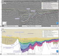
File:M115CH02FG04.jpg West-east seismic section across the South Viking Graben, through Sycamore field. Location shown on [[South Viking Graben|Figures 1, 2, 3]]. Courtesy of PGS(700 × 662 (290 KB)) - 21:44, 10 January 2019
File:M91FG185.JPG ...ory.com). From Shepherd, M., 2009, Deltaic reservoirs, in M. Shepherd, Oil field production geology: AAPG Memoir 91, p. 279-288.(800 × 989 (133 KB)) - 18:40, 13 August 2015
File:Basic-seismic-processing fig1.png A single shot record as it is recorded in the field. The shot is at station 60. There were 120 geophones laid out in this “sp(1,946 × 2,027 (504 KB)) - 19:35, 14 January 2014
File:Subsurface-maps fig2.png ...re of the base of the Humber unconformity (top of the Brent Group), Dunlin field, U.K. Northern North Sea mapped with 1979 and 1989 vintage data. Contours a(936 × 1,378 (102 KB)) - 20:42, 14 January 2014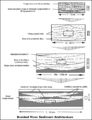
File:M91FG182.JPG .... From Shepherd, M., 2009, Braided fluvial reservoirs, in M. Shepherd, Oil field production geology: AAPG Memoir 91, p. 273-277.(800 × 1,040 (126 KB)) - 18:47, 12 August 2015
File:M91FG178.JPG ...rom Shepherd, M., 2009, Meandering fluvial reservoirs, in M. Shepherd, Oil field production geology: AAPG Memoir 91, p. 261-272.(800 × 1,042 (186 KB)) - 21:26, 3 August 2015- ...on for a field and looks for ways of getting more hydrocarbons out of that field. In a large company, this team will include some combination of the job tit ...s within a subsurface team.<ref name=Shepherd_2009>Shepherd, M., 2009, Oil Field Production Geology: [http://store.aapg.org/detail.aspx?id=788 AAPG Memoir 93 KB (424 words) - 14:54, 10 November 2014
- ...ortant step of any field project. Once this is done, the objectives of the field program fall into place. * [[Preparing to go to the field]]2 KB (354 words) - 22:07, 1 February 2022
File:M115CH10FG01.jpg Location map of the Kingfisher field in UKCS Blocks 16/8a and 16/8d showing the nearby producing Brae area field(1,279 × 723 (781 KB)) - 18:33, 17 January 2019- ...ts and not necessarily in response to structural [[dip]]. Gas in the Beryl field, for example, migrated downdip during production in response to changing pr ==Fault seal and field unitization==3 KB (479 words) - 15:21, 30 March 2022
File:M91FG112.JPG ...draulic units showing different pressures. This example is from the Magnus field in the UK North Sea (from Morris et al., 1999). Reprinted with permission f(800 × 856 (118 KB)) - 19:29, 18 August 2015
File:M115CH11FG04.jpg ...an additional trapping mechanism (line of section illustrated on [[Thelma field|Figure 2]]). From AAPG Memoir 115—Rift-Related Coarse-Grained Submarine F(1,277 × 860 (520 KB)) - 15:21, 22 January 2019- ...sification-of-exploration-traps_fig2-3.png|{{figure number|1}}Upper Valley field, Utah. Courtesy Rocky Mountain Association of Geologists. ...traps_fig2-4.png|{{figure number|2}}Formal classification for Upper Valley field.4 KB (538 words) - 18:47, 12 April 2022

File:M91FG180.JPG ...rom Shepherd, M., 2009, Meandering fluvial reservoirs, in M. Shepherd, Oil field production geology: AAPG Memoir 91, p. 261-272.(800 × 474 (56 KB)) - 15:53, 10 August 2015- ...Ogyopsis klotzi from the Mt. Stephen Trilobite Beds (Middle Cambrian) near Field, British Columbia, Canada.; Photograph taken by Mark A. Wilson (Department563 bytes (70 words) - 18:08, 2 February 2015
File:M91Ch13FG85.JPG .... From Shepherd, M., 2009, Structural geology: Faults, in M. Shepherd, Oil field production geology: AAPG Memoir 91, p. 107-122.(600 × 303 (34 KB)) - 21:34, 29 April 2015
File:Evaluating-structurally-complex-reservoirs fig3.png Cross section through an asymmetric ramp anticline, Whitney Canyon field, Wyoming, with SCAT and isogon data superimposed. Unconformities, axial pla(942 × 1,424 (112 KB)) - 18:47, 14 January 2014
File:M91Ch13FG94.JPG .... From Shepherd, M., 2009, Structural geology: Faults, in M. Shepherd, Oil field production geology: AAPG Memoir 91, p. 107-122.(800 × 345 (49 KB)) - 21:41, 29 April 2015


