Tectonostratigraphic history
| Exploring for Oil and Gas Traps | |

| |
| Series | Treatise in Petroleum Geology |
|---|---|
| Part | Critical elements of the petroleum system |
| Chapter | Sedimentary basin analysis |
| Author | John M. Armentrout |
| Link | Web page |
| Store | AAPG Store |
Models of tectonic history provide a framework for understanding the history of each phase of basin development. A tectonostratigraphic phase is a period of basin evolution during which tectonic and stratigraphic elements resulted in a specific configuration of depositional and deformational elements, many of which were critical to the evolution of the basin's petroleum system. The tectonostratigraphic history for a basin is usually portrayed in a time series of cross sections, showing the geologic elements of each phase. Because all basins are three dimensional, care must be taken to assemble enough cross sections to depict basin history accurately.
Example: the GOM basin
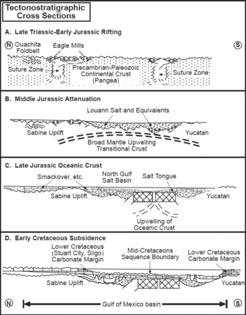
Figure 1 Schematic diagram showing a series of cross sections representing the four phases of Late Triassic to Early Cretaceous evolution of the GOM basin. Modified from Buffler.[1] Courtesy New Orleans Geological Society.
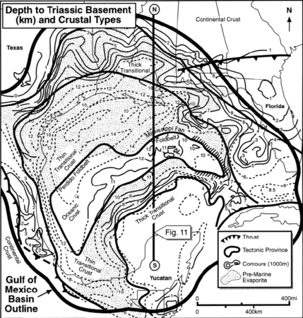
Figure 2 Location of Figure 1. Modified from Buffler.[1] Courtesy New Orleans Geological Society.
Figure 3 Phase E began during the mid-Cenomanian with a rapid fall and rise of sea level superimposed on a long-term rise that terminally drowned the outer margins of the carbonate platforms, causing the margins to retreat landward. From Hall et al.;[2] courtesy Gulf Coast SEPM.


Tectonic evolution of the Gulf of Mexico basin has resulted in five primary tectonostratigraphic phases (A–E), each with a different sediment accumulation and deformation history. Figure 1 is a schematic diagram showing a series of cross sections representing the four phases of Late Triassic to Early Cretaceous evolution of the GOM basin (see Figure 2 for the location).
Phase A
Figure 1A consists of Late Triassic to Early Jurassic rifting along linear zones within brittle crust with deposition of synrift nonmarine sediments and volcanics within half-grabens.
Phase B
Figure 1B of Middle Jurassic age is characterized by rifting and attenuation of the crust, with formation of transitional crust and the associated basement highs and lows that form the basic architecture. The outer periphery of the basin underwent moderate stretching and the crust remained thick, forming broad arches and basins. The central basin underwent considerable stretching and subsidence to form a large area of thin transitional crust over which thick salt was deposited. Nonmarine terrigenous sediments continued to be deposited within the peripheral grabens.
Phase C
Figure 1C of Late Jurassic age consists of emplacement of oceanic crust as mantle upwelling concentrated along the generally east–west-trending weakness in the continental crust. As the crust underlying the basin began to cool, subsidence resulted in the relative rise of sea level. The basin margins were transgressed by broad shallow-to-deep shelfal marine environments with deposition of thick carbonate successions. Locally, thick, terrigenous clastic prisms prograded into the basin. Potential and known reservoirs occur within both the carbonate and clastic depositional systems of this tectonostratigraphic phase. During the Late Jurassic maximum transgression, the deep basin was sediment starved, and thick, organic-rich shales accumulated in lowoxygen environments (source-rock types 6 and 7).
Phase D
Figure 1D of Early Cretaceous age is characterized by broad carbonate platforms rimmed by reef buildups along the margins established at the boundary of differential subsidence between thin and thick crust. Fine-grained carbonates were deposited in the adjacent deep basin. Terrigenous clastics continued to be input at local points along the northern margin. Known and potential reservoirs occur within both carbonate and clastic depositional systems of these early Cretaceous rocks.
Phase E
Phase E (Figure 3) began during the mid-Cenomanian with a rapid fall and rise of sea level superimposed on a long-term rise that terminally drowned the outer margins of the carbonate platforms, causing the margins to retreat landward. Widespread submarine erosion created a prominent mid-Cretaceous unconformity. Subsequent deposition was dominated by terrigenous sedimentation as large clastic prisms prograded first from the west and northwest in the Late Cretaceous and early Cenozoic and then from the north (Mississippi River drainage) during the late Cenozoic. Most of the offshore and many onshore reservoirs occur within these Late Cretaceous and Cenozoic siliciclastic deposits. The prograding prisms of siliciclastic sediment differentially loaded the underlying salt, resulting in deformation by both salt mobility and down-to-the-basin growth faulting along the shelf-slope break.[3][4]
See also
- Cross section
- Regional maps and cross sections
- Structural maps and cross sections
- Making regional tectonic maps
- Making regional structural cross sections
- Determining plate tectonic setting and history
- Using a tectonic history model for petroleum system analysis
References
- ↑ 1.0 1.1 Buffler, R. T., 1991, Early evolution of the Gulf of Mexico basin, in D. Goldthwaite, ed., An introduction to Central Gulf Coast geology: New Orleans Geological Society, p. 1-16.
- ↑ Hall, D. J., B. E. Bowen, R. N. Rosen, S. Wu, and A. W. Bally, 1993, Mesozoic and early Cenozoic development of the Texas margin: a new integrated cross-section from the Cretaceous shelf edge to the Perdido fold belt: Selected Papers, Gulf Coast Section SEPM 13th Annual Research Conference, p. 21–31.
- ↑ Bruce, C., H., 1973, Pressured shale and related sediment deformation: mechanism for development of regional contemporaneous faults: AAPG Bulletin, vol. 57, p. 878–886, DOI: 10.1306/819A4352-16C5-11D7-8645000102C1865D.
- ↑ Winker, C., D., Edwards, M., B., 1983, Unstable progradational clastic shelf margins: SEPM Special Publication 33, p. 139–157.
External links
| find literature about Tectonostratigraphic history |