Making regional tectonic maps
| Exploring for Oil and Gas Traps | |

| |
| Series | Treatise in Petroleum Geology |
|---|---|
| Part | Critical elements of the petroleum system |
| Chapter | Sedimentary basin analysis |
| Author | John M. Armentrout |
| Link | Web page |
| Store | AAPG Store |
Tectonic maps of a basin and surrounding areas, in combination with regional structure cross sections, give an overall impression of the geologic architecture of the basin and form the base from which other interpretations are made. A large-scale map shows the depth to the basement in the basin and the distribution of crustal types. Always be sure important tectonic elements are shown, such as specific fold belts and major faults.
Tectonic map
Figure 1 is a tectonic map of the Gulf of Mexico (GOM; see General facts about the Gulf of Mexico) basin. It shows the following:
- Generalized depth to basement (approximately the base of Jurassic sedimentary rock)
- Distribution of four crustal types—continental, thick transitional, thin transitional, and oceanic
- Known distribution of mid-Jurassic evaporites (pre-marine evaporites)
- Several major structural features
The thickest sediments occur over the thin transitional crust, which has subsided beneath the load of more than distance::14 km (>45,000 ft) of sedimentary rock. (For additional discussion of the structural framework, see Jones and Freed.[1])
Salt tectonic map
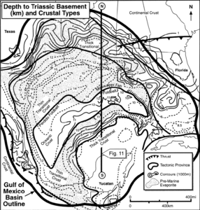
Figure 1 Tectonic map of the Gulf of Mexico. Modified from Buffler.[2] Courtesy New Orleans Geological Society.
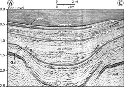
Figure 2 Depositional strike seismic reflection profile across a valley.
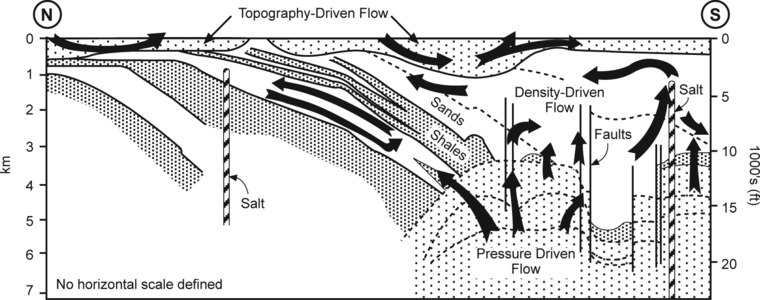
Figure 3 Regional cross section summarizing the regional hydraulic flow regimes of the Louisiana Gulf Coast above a depth of 20,000 ft (6096 m). From Hanor and Sassen.[3] Courtesy Gulf Coast SEPM.
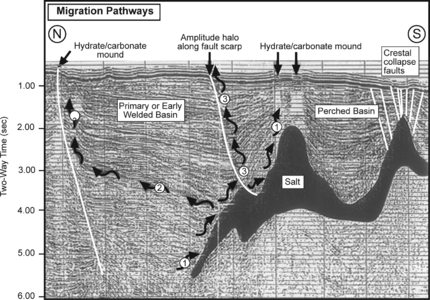
Figure 4 North–south 3-D seismic reflection profile illustrating three possible hydrocarbon migration pathways and related sea-bed features. Based on data from Lovely and Ruggiero.[4]
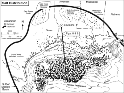
Figure 5 Salt structures in the northwestern Gulf of Mexico and adjacent interior basins. Modified from Jackson and Galloway.[5]


The stratigraphic and tectonic history of the GOM basin is strongly affected by salt tectonics. As a consequence of differential loading of salt by sediment sourced from the North American craton (see Great American carbonate bank, the distribution of salt-cored structures is oldest in the onshore northern margin of the basin where Late Cretaceous and early Cenozoic progradation resulted in salt-structure growth.
Offshore beneath GOM waters, evacuation of salt structures is oldest in the north and is progressively younger toward the south. However, there are Late Jurassic and Early Cretaceous salt-cored structures along the Sigsbee Escarpment. Pliocene and Pleistocene depositional loading has displaced salt basinward and differentially loaded detached salt sills into salt-cored massifs and salt-cored diapirs.
The salt-withdrawal synclines formed by sediment loading result in bathymetric lows that serve as sediment transport pathways down the slope.[6] The presentday sea-floor bathymetry of the northern Gulf of Mexico slope reflects this transport-pathway lineation of salt-withdrawal synclines bordered by salt-cored anticlines (see Figure 2). The distribution of the sediment-thick synclines and salt-core anticlines persists through time, resulting in predictability of sediment transport avenues, depositional areas of potential reservoir sands, and conduits from deeply buried source rocks upward to the hydrocarbon traps (see Figures 3 and Figure 4).
McGuinness and Hossack[7] present an excellent discussion of palinspastic reconstruction of the stratigraphic record disrupted by salt tectonics. Jackson et al.[8] and Simmons et al.[9]
Figure 5 salt structures in the northwestern Gulf of Mexico and adjacent interior basins.
See also
- Making regional structural cross sections
- Determining plate tectonic setting and history
- Determining tectonostratigraphic history
- Using a tectonic history model for petroleum system analysis
- Cross section
- Regional maps and cross sections
- Structural maps and cross sections
References
- ↑ Jones, J. O., and R. L. Freed, eds., 1996, Structural Framework of the Northern Gulf of Mexico: Gulf Coast Association of Geological Sciences, 112 p.
- ↑ Buffler, R. T., 1991, Early evolution of the Gulf of Mexico basin, in D. Goldthwaite, ed., An introduction to Central Gulf Coast geology: New Orleans Geological Society, p. 1-16.
- ↑ Hanor, J. S., and R. Sassen, 1990 Evidence for large-scale vertical and lateral migration of formation waters, dissolved salt, and crude oil in the Louisiana Gulf Coast: Proceedings, Gulf Coast Section SEPM 9th Annual Research Conference, p. 283-296.
- ↑ Lovely and Ruggiero, 1995, personal communication
- ↑ Jackson, M. P. A., and W. E. Galloway, 1984, Structural and depositional styles of Gulf Coast Tertiary continental margins: Applications to hydrocarbon exploration: AAPG Continuing Education Course Notes Series 25, 226 p.
- ↑ Bouma, A., H., 1982, Intraslope basins in northwest Gulf of Mexico: a key to ancient submarine canyons and fans, in Watkins, J. S. and C. L. Drake, Studies in Continental Margin Geology: AAPG Memoir 34, p. 567–581.
- ↑ McGuinness, D. B., and J. R. Hossack, 1993, The development of allochthonous salt sheets as controlled by the rates of extension, sedimentation, and salt supply: Proceedings, Gulf Coast Section SEPM 14th Annual Research conference, p. 127–139.
- ↑ Jackson, M. P. A., D. G. Roberts, and J. S. Snelson, eds., 1995, Salt Tectonics: AAPG Memoir 65, 454 p.
- ↑ Simmons, G. R., W. R. Bryant, G. Lee, and C. Fiduk, 1996, Regional distribution of salt and basin architecture in the northwestern Gulf of Mexico, in J. O. Jones, and R. L. Freed, eds., Structural Framework of the Northern Gulf of Mexico: Gulf Coast Assoc. of Geological Societies Special Publication, p. 93–94. Presents a good discussion of salt distribution and tectonics.
External links
| find literature about Making regional tectonic maps |