Difference between revisions of "East Breaks depositional sequence"
FWhitehurst (talk | contribs) |
Cwhitehurst (talk | contribs) |
||
| Line 16: | Line 16: | ||
Each [[depocenter]] has a unique depositional history that reflects the integration of all responses to depositional processes and environmental factors, including [[tectonics]], [[climate]], [[sediment supply]], and [[Sea level cycles and climate|sea level variation]]. These factors result in cycles of deposition: the sediments accumulated during each cycle are the depositional sequence. Integration of multiple data sets, including (1) [[Seismic data|seismic reflection profiles]], (2) [[Biostratigraphy in sequence stratigraphy|biostratigraphic analyses]], (3) [[Basic open hole tools|wireline logs]], (4) [[Core description|cores]], and (5) detailed measured sections, helps us define the depositional sequences and interpret primary factors affecting formation of each cycle. Precise mapping of each depositional sequence within each depocenter requires careful data integration. | Each [[depocenter]] has a unique depositional history that reflects the integration of all responses to depositional processes and environmental factors, including [[tectonics]], [[climate]], [[sediment supply]], and [[Sea level cycles and climate|sea level variation]]. These factors result in cycles of deposition: the sediments accumulated during each cycle are the depositional sequence. Integration of multiple data sets, including (1) [[Seismic data|seismic reflection profiles]], (2) [[Biostratigraphy in sequence stratigraphy|biostratigraphic analyses]], (3) [[Basic open hole tools|wireline logs]], (4) [[Core description|cores]], and (5) detailed measured sections, helps us define the depositional sequences and interpret primary factors affecting formation of each cycle. Precise mapping of each depositional sequence within each depocenter requires careful data integration. | ||
| + | This article discusses the concept of depositional sequences and how to identify them, using a data set from the High Island–East Breaks area. The location of this study area is shown on the depocenter maps of Figures [[:File:Sedimentary-basin-analysis_fig4-13.png|1]] through [[:file:Sedimentary-basin-analysis_fig4-13.png|4]]. | ||
| + | |||
| + | <gallery mode=packed heights=300px widths=300px> | ||
| + | File:Sedimentary-basin-analysis_fig4-13.png|{{figure number|1}} | ||
| + | File:Sedimentary-basin-analysis_fig4-14.png|{{figure number|2}} | ||
| + | File:Sedimentary-basin-analysis_fig4-15.png|{{figure number|3}} | ||
| + | File:Sedimentary-basin-analysis_fig4-16.png|{{figure number|4}} | ||
| + | File:Sedimentary-basin-analysis_fig4-17.png|{{figure number|5}} | ||
| + | </gallery> | ||
| + | |||
| + | ==Examples in this section== | ||
| + | [[:File:Sedimentary-basin-analysis_fig4-17.png|Figure 5]] is a map of the study area, showing the named offshore exploration areas and bathymetry. It also shows the locations of the East Breaks 160-161 field, illustrated seismic profiles and a reference well. | ||
==See also== | ==See also== | ||
| Line 24: | Line 36: | ||
* [[Recognizing stacked depositional sequences in seismic profiles]] | * [[Recognizing stacked depositional sequences in seismic profiles]] | ||
* [[Recognizing stacked depositional sequences from well data]] | * [[Recognizing stacked depositional sequences from well data]] | ||
| − | |||
| − | |||
| − | |||
==External links== | ==External links== | ||
Revision as of 20:31, 15 October 2014
| Exploring for Oil and Gas Traps | |

| |
| Series | Treatise in Petroleum Geology |
|---|---|
| Part | Critical elements of the petroleum system |
| Chapter | Sedimentary basin analysis |
| Author | John M. Armentrout |
| Link | Web page |
| Store | AAPG Store |
Each depocenter has a unique depositional history that reflects the integration of all responses to depositional processes and environmental factors, including tectonics, climate, sediment supply, and sea level variation. These factors result in cycles of deposition: the sediments accumulated during each cycle are the depositional sequence. Integration of multiple data sets, including (1) seismic reflection profiles, (2) biostratigraphic analyses, (3) wireline logs, (4) cores, and (5) detailed measured sections, helps us define the depositional sequences and interpret primary factors affecting formation of each cycle. Precise mapping of each depositional sequence within each depocenter requires careful data integration.
This article discusses the concept of depositional sequences and how to identify them, using a data set from the High Island–East Breaks area. The location of this study area is shown on the depocenter maps of Figures 1 through 4.
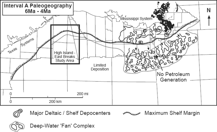
Figure 1
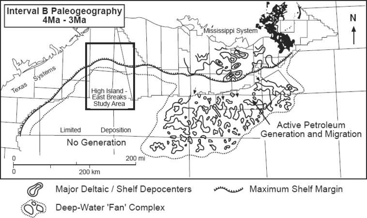
Figure 2
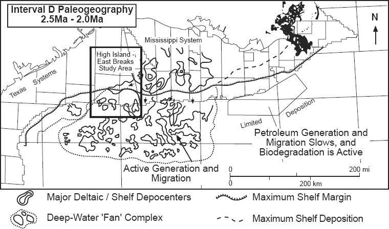
Figure 3

Figure 4
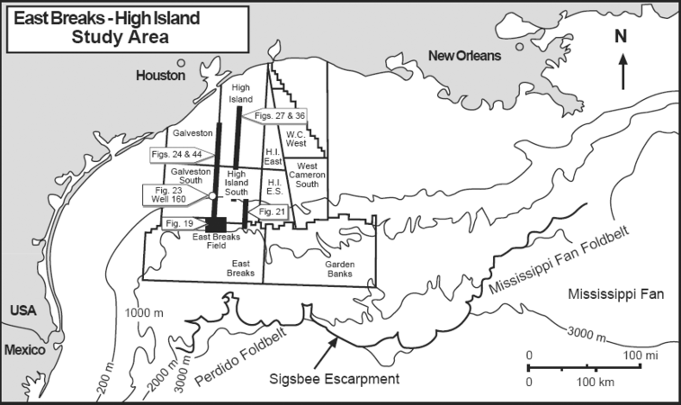
Figure 5


Examples in this section
Figure 5 is a map of the study area, showing the named offshore exploration areas and bathymetry. It also shows the locations of the East Breaks 160-161 field, illustrated seismic profiles and a reference well.
See also
- Definitions of depositional system elements
- Identifying depositional sequences
- Identifying depositional sequences in seismic sections
- Identifying depositional sequences from biostratigraphic data
- Recognizing stacked depositional sequences in seismic profiles
- Recognizing stacked depositional sequences from well data
External links
| find literature about East Breaks depositional sequence |