Difference between revisions of "Meandering fluvial reservoirs"
Cwhitehurst (talk | contribs) |
Cwhitehurst (talk | contribs) |
||
| (8 intermediate revisions by the same user not shown) | |||
| Line 13: | Line 13: | ||
| isbn = 0891813721 | | isbn = 0891813721 | ||
}} | }} | ||
| − | [[Fluvial]] reservoirs are difficult for the production geologist to understand, characterize, and model. One major problem involves trying to classify fluvial reservoirs in the [[subsurface]]. The system used in this article broadly categorizes fluvial systems into meandering and [[braided fluvial reservoirs]]. Although this is a classification used by many production geologists, not all experts are happy with this approach; some believe the classification to be too prescriptive. They consider that only limited inferences can be made from core and log data as to the overall geometry of a fluvial reservoir in the subsurface (e.g., Bridge<ref name=Bridge_2003>Bridge, J. S., 2003, Rivers and flood plains: Forms, processes and sedimentary record: Oxford, Blackwell, 491 p.</ref>). Because of this, some geologists prefer to use a simple nongeneric description by classifying subsurface fluvial geometries as either sheets or ribbons.<ref name=Friendetal_1979>Friend, P. F., M. J. Slater, and R. C. Williams, 1979, [http://jgs.geoscienceworld.org/content/136/1/39.abstract Vertical and lateral building of river sandstone bodies, Ebro Basin, Spain]: Journal of the Geological Society of London, v. 136, p. 39–46.</ref> | + | [[Fluvial]] reservoirs are difficult for the production geologist to understand, characterize, and model. One major problem involves trying to classify fluvial reservoirs in the [[subsurface]]. The system used in this article broadly categorizes fluvial systems into meandering and [[braided fluvial reservoirs]]. Although this is a classification used by many production geologists, not all experts are happy with this approach; some believe the classification to be too prescriptive. They consider that only limited inferences can be made from core and log data as to the overall geometry of a fluvial reservoir in the subsurface (e.g., Bridge<ref name=Bridge_2003>Bridge, J. S., 2003, Rivers and flood plains: Forms, processes and sedimentary record: Oxford, Blackwell, 491 p.</ref>). Because of this, some geologists prefer to use a simple nongeneric description by classifying subsurface fluvial geometries as either sheets or ribbons.<ref name=Friendetal_1979>Friend, P. F., M. J. Slater, and R. C. Williams, 1979, [http://jgs.geoscienceworld.org/content/136/1/39.abstract Vertical and [[lateral]] building of river sandstone bodies, Ebro Basin, Spain]: Journal of the Geological Society of London, v. 136, p. 39–46.</ref> |
| − | [[file:M91Ch11FG70.JPG|thumb|300px|{{figure number|1}}A point bar cut into the underlying Ivan limestone as picked out by varying seismic amplitudes on a horizon display, late Pennsylvanian to Early Permian, Baylor County, Texas (from Burnett<ref name=Burnett_1996>Burnett, M., 1996, [http://archives.datapages.com/data/specpubs/study42/ch05/0062.htm 3-D seismic expression of a shallow fluvial system in west central Texas], in P. Weimer and T. L. Davis, eds.: AAPG Studies in Geology 42 and SEG (Society of Exploration Geophysicists) Geophysical Developments Series 5, p. 45–56.</ref>). Reprinted with permission from the AAPG.]] | + | [[file:M91Ch11FG70.JPG|thumb|300px|{{figure number|1}}A point bar cut into the underlying Ivan [[limestone]] as picked out by varying seismic amplitudes on a horizon display, late Pennsylvanian to Early Permian, Baylor County, Texas (from Burnett<ref name=Burnett_1996>Burnett, M., 1996, [http://archives.datapages.com/data/specpubs/study42/ch05/0062.htm 3-D seismic expression of a shallow fluvial system in west central Texas], in P. Weimer and T. L. Davis, eds.: AAPG Studies in Geology 42 and SEG (Society of Exploration Geophysicists) Geophysical Developments Series 5, p. 45–56.</ref>). Reprinted with permission from the AAPG.]] |
Despite the above difficulties, the production geologist will nevertheless try and find some basis for providing a predictive model for the subsurface geology of a fluvial reservoir. Seismic data can help to determine the planform geometry where it is of sufficient resolution ([[:file:M91Ch11FG70.JPG|Figure 1]]). Fluvial geometries can sometimes be well differentiated on horizon slice amplitude displays (e.g., Brown et al.,<ref name=Brownetal_1981>Brown, A. R., C. G. Dahm, and R. J. Graebner, 1981, A stratigraphic case history using three-dimensional seismic data in the Gulf of Thailand: Geophysical Prospecting, v. 29, no. 3, p. 327–349.</ref> Rijks and Jauffred,<ref name=Rijksandjauffred_1991>Rijks, E. J. K., and J. C. E. M. Jauffred, 1991, Attribute extraction: An important application in any detailed 3D interpretation study: Leading Edge, v. 10, no. 9, p. 11–19.</ref> Noah et al.,<ref name=Noahetal_1992>Noah, J. T., G. S. Hofland, and K. Lemke, 1992, Seismic interpretation of meander channel point-bar deposits using realistic seismic modeling techniques: The Leading Edge, v. 11, p. 13–18.</ref> Carter<ref name=Carter_2003>Carter, D. C., 2003, [http://archives.datapages.com/data/bulletns/2003/06jun/0909/0909.HTM 3-D seismic geomorphology: Insights into fluvial reservoir deposition and performance, Widuri field, Java Sea]: AAPG Bulletin, v. 87, no. 6, p. 909–934.</ref>). | Despite the above difficulties, the production geologist will nevertheless try and find some basis for providing a predictive model for the subsurface geology of a fluvial reservoir. Seismic data can help to determine the planform geometry where it is of sufficient resolution ([[:file:M91Ch11FG70.JPG|Figure 1]]). Fluvial geometries can sometimes be well differentiated on horizon slice amplitude displays (e.g., Brown et al.,<ref name=Brownetal_1981>Brown, A. R., C. G. Dahm, and R. J. Graebner, 1981, A stratigraphic case history using three-dimensional seismic data in the Gulf of Thailand: Geophysical Prospecting, v. 29, no. 3, p. 327–349.</ref> Rijks and Jauffred,<ref name=Rijksandjauffred_1991>Rijks, E. J. K., and J. C. E. M. Jauffred, 1991, Attribute extraction: An important application in any detailed 3D interpretation study: Leading Edge, v. 10, no. 9, p. 11–19.</ref> Noah et al.,<ref name=Noahetal_1992>Noah, J. T., G. S. Hofland, and K. Lemke, 1992, Seismic interpretation of meander channel point-bar deposits using realistic seismic modeling techniques: The Leading Edge, v. 11, p. 13–18.</ref> Carter<ref name=Carter_2003>Carter, D. C., 2003, [http://archives.datapages.com/data/bulletns/2003/06jun/0909/0909.HTM 3-D seismic geomorphology: Insights into fluvial reservoir deposition and performance, Widuri field, Java Sea]: AAPG Bulletin, v. 87, no. 6, p. 909–934.</ref>). | ||
| Line 26: | Line 26: | ||
==Geometry of meander belts== | ==Geometry of meander belts== | ||
| − | Meandering rivers deposit sand and mud within well-defined meander belts. The appearance of a meander belt in plan and cross section is of a complex labyrinth of interlocking sand bodies on the scale of hundreds of meters, embedded within varying volumes of mud ([[:file:M91FG173.JPG|Figure 2]]). The mud can make up 50% or more of the volume. Channel features, where they survive, tend to be plugged with clay ([[:file:M91FG173.JPG|Figure 2]], [[:file:M91FG174.JPG|Figure 3]]). | + | Meandering rivers deposit sand and mud within well-defined meander belts. The appearance of a meander belt in plan and [[cross section]] is of a complex labyrinth of interlocking sand bodies on the scale of hundreds of meters, embedded within varying volumes of mud ([[:file:M91FG173.JPG|Figure 2]]). The mud can make up 50% or more of the volume. Channel features, where they survive, tend to be plugged with clay ([[:file:M91FG173.JPG|Figure 2]], [[:file:M91FG174.JPG|Figure 3]]). |
Gibling<ref name=Gibling_2006>Gibling, M. R. 2006, [http://jsedres.geoscienceworld.org/content/76/5/731?related-urls=yes&legid=jsedres;76/5/731 Width and thickness of fluvial channel bodies and valley fills in the geological record: A literature compilation and classification]: Journal of Sedimentary Research, v. 76, p. 731–770.</ref> provided data on width and thickness relationships for fluvial systems in various settings from [[Quaternary]] and older outcrops (Table 1). He found that meandering rivers do not generally create thick sedimentary packages. The maximum thickness for meandering river deposits in his database is only 38 m (124 ft), with 4–20 m (13–65 ft) as a common thickness range. Gibling makes the comment that despite their familiarity in the modern landscape, meandering river deposits probably constitute only a minor portion of the fluvial rock record by comparison to braided systems. This may be because the organized flow patterns associated with meandering rivers rarely persist for long periods. | Gibling<ref name=Gibling_2006>Gibling, M. R. 2006, [http://jsedres.geoscienceworld.org/content/76/5/731?related-urls=yes&legid=jsedres;76/5/731 Width and thickness of fluvial channel bodies and valley fills in the geological record: A literature compilation and classification]: Journal of Sedimentary Research, v. 76, p. 731–770.</ref> provided data on width and thickness relationships for fluvial systems in various settings from [[Quaternary]] and older outcrops (Table 1). He found that meandering rivers do not generally create thick sedimentary packages. The maximum thickness for meandering river deposits in his database is only 38 m (124 ft), with 4–20 m (13–65 ft) as a common thickness range. Gibling makes the comment that despite their familiarity in the modern landscape, meandering river deposits probably constitute only a minor portion of the fluvial rock record by comparison to braided systems. This may be because the organized flow patterns associated with meandering rivers rarely persist for long periods. | ||
| Line 71: | Line 71: | ||
[[file:M91FG177.JPG|thumb|300px|{{figure number|6}}Upward-decreasing permeability profile in a point bar sandstone in the Peoria field, Colorado (from Chapin and Mayer<ref name=Chapinandmayer_1991>Chapin, M. A., and D. F. Mayer, 1991, [http://archives.datapages.com/data/sepm_sp/csp3/Constructing_a_Three-DimensionalOp.htm Constructing a three-dimensional rock property model of fluvial sandstones in the Peoria field, Colorado], in A. D. Miall and N. Tyler, eds., The three dimensional facies architecture of terrigenous clastic sediments and its implication for hydrocarbon discovery and recovery: SEPM Concepts in Sedimentology and Paleontology 3, p. 160–171.</ref>). Reprinted with permission from, and © by, the SEPM (Society for Sedimentary Geology).]] | [[file:M91FG177.JPG|thumb|300px|{{figure number|6}}Upward-decreasing permeability profile in a point bar sandstone in the Peoria field, Colorado (from Chapin and Mayer<ref name=Chapinandmayer_1991>Chapin, M. A., and D. F. Mayer, 1991, [http://archives.datapages.com/data/sepm_sp/csp3/Constructing_a_Three-DimensionalOp.htm Constructing a three-dimensional rock property model of fluvial sandstones in the Peoria field, Colorado], in A. D. Miall and N. Tyler, eds., The three dimensional facies architecture of terrigenous clastic sediments and its implication for hydrocarbon discovery and recovery: SEPM Concepts in Sedimentology and Paleontology 3, p. 160–171.</ref>). Reprinted with permission from, and © by, the SEPM (Society for Sedimentary Geology).]] | ||
| − | Fining-upward profiles are typical for point bars; the permeability declines upward with decreasing grain size ([[:file:M91FG177.JPG|Figure 6]]). The decrease in permeability commonly occurs in a step-like fashion rather than showing a gradual upward decrease. | + | Fining-upward profiles are typical for point bars; the permeability declines upward with decreasing [[grain size]] ([[:file:M91FG177.JPG|Figure 6]]). The decrease in permeability commonly occurs in a step-like fashion rather than showing a gradual upward decrease. |
Upward-decreasing permeability profiles are unfavorable to efficient sweep. Water will flood through the high-permeability basal part of the point bar leaving the uppermost section unswept ([[:file:M91FG176.JPG|Figure 5b]]). | Upward-decreasing permeability profiles are unfavorable to efficient sweep. Water will flood through the high-permeability basal part of the point bar leaving the uppermost section unswept ([[:file:M91FG176.JPG|Figure 5b]]). | ||
| Line 100: | Line 100: | ||
[[file:M91FG179.JPG|thumb|300px|{{figure number|8}}Net sand isochore map of the Q reservoir in the Little Creek field in Mississippi. The reservoir comprises three connected point bar sandstones in a background of floodplain mudstones and siltstones. Just to the north is the Sweetwater field, which produces from a depositionally isolated point bar in the same meander belt system (from Werren et al., 1990). Reprinted with permission from, and © by, Springer Ltd.]] | [[file:M91FG179.JPG|thumb|300px|{{figure number|8}}Net sand isochore map of the Q reservoir in the Little Creek field in Mississippi. The reservoir comprises three connected point bar sandstones in a background of floodplain mudstones and siltstones. Just to the north is the Sweetwater field, which produces from a depositionally isolated point bar in the same meander belt system (from Werren et al., 1990). Reprinted with permission from, and © by, Springer Ltd.]] | ||
| − | Technical papers indicate that connectivity in meander belt sediments can be highly variable and prone to chance factors. An example of this is the Little Creek field in Mississippi.<ref name=Werrenetal_1990 /> The lower reservoir unit comprises three connected point bar sandstones ([[:file:M91FG179.JPG|Figure 8]]). The Sweetwater field immediately to the north is believed to form part of the same fluvial system and produces from a fourth point bar sand body along the same trend. Nevertheless, the Sweetwater field is isolated from the Little Creek field on the evidence of a 24-m (79-ft) higher oil-water contact. The two fields are thought to be separated by a shale plug or an area with relatively high capillary displacement pressure. A similar observation was made by Carter<ref name=Carter_2003 /> for a meander belt reservoir in the Widuri field in the Java Sea. Following the depletion of a well on the updip side of a 100-m (328-ft)-wide abandoned channel, a second well was drilled on the opposite site of the clay plug. A full oil column was found in the new well, unaffected by production from the previous well. In the Saddle Lake area of Alberta, Canada, oil and gas pools are restricted to point bars completely surrounded by clay plugs.<ref name=Edieandandrichuk_2003>Edie, R. W., and J. M. Andrichuk, 2003, [http://bcpg.geoscienceworld.org/content/51/3/253.short Meander belt entrapment of hydrocarbons at Saddle Lake, Alberta and an untested in situ combustion scheme for recovery of heavy oil]: Bulletin of Canadian Petroleum Geology, v. 51, no. 3, p. 253–274.</ref> | + | Technical papers indicate that connectivity in meander belt sediments can be highly variable and prone to chance factors. An example of this is the Little Creek field in Mississippi.<ref name=Werrenetal_1990 /> The lower reservoir unit comprises three connected point bar sandstones ([[:file:M91FG179.JPG|Figure 8]]). The Sweetwater field immediately to the north is believed to form part of the same fluvial system and produces from a fourth point bar sand body along the same trend. Nevertheless, the Sweetwater field is isolated from the Little Creek field on the evidence of a 24-m (79-ft) higher oil-water contact. The two fields are thought to be separated by a shale plug or an area with relatively high capillary [[displacement pressure]]. A similar observation was made by Carter<ref name=Carter_2003 /> for a meander belt reservoir in the Widuri field in the Java Sea. Following the depletion of a well on the updip side of a 100-m (328-ft)-wide abandoned channel, a second well was drilled on the opposite site of the clay plug. A full oil column was found in the new well, unaffected by production from the previous well. In the Saddle Lake area of Alberta, Canada, oil and gas pools are restricted to point bars completely surrounded by clay plugs.<ref name=Edieandandrichuk_2003>Edie, R. W., and J. M. Andrichuk, 2003, [http://bcpg.geoscienceworld.org/content/51/3/253.short Meander belt entrapment of hydrocarbons at Saddle Lake, Alberta and an untested in situ combustion scheme for recovery of heavy oil]: Bulletin of Canadian Petroleum Geology, v. 51, no. 3, p. 253–274.</ref> |
It seems from these case examples that clay plugs can be an important element limiting horizontal connectivity in meander belt sediments ([[:file:M91FG176.JPG|Figure 5d]]). Some point bars show flow connectivity with each other, others do not. Connectivity may be effective where the clay plug does not totally separate two point bars areally. Richardson et al.<ref name=Richardsonetal_1987>Richardson, J. G., J. B. Sangree, and R. M. Sneider, 1987, Meandering stream reservoirs: Journal of Petroleum Technology, v. 39, no. 12, p. 1501–1502.</ref> noted that there is commonly some sand or gravel underneath clay plugs that can allow communication. Similar observations have been made by Donselaar and Overeem.<ref name=Donselaarandovereem_2008>Donselaar, M. E., and I. Overeem, 2008, [http://archives.datapages.com/data/bulletns/2008/09sep/BLTN07079/BLTN07079.HTM Connectivity of fluvial point bar deposits: An example from the Miocene Huesca fluvial fan, Ebro basin, Spain]: AAPG Bulletin, v. 92, no. 9, p. 1109–1129.</ref> Clay plugs occur at the same level of the point bar that it partially encloses. If vertical connectivity is effective between incised point bars, the clay plug obstruction can be bypassed above and below. If no effective vertical communication occurs, then clay plugs are more likely to act as lateral flow barriers ([[:file:M91FG176.JPG|Figure 5e]]). | It seems from these case examples that clay plugs can be an important element limiting horizontal connectivity in meander belt sediments ([[:file:M91FG176.JPG|Figure 5d]]). Some point bars show flow connectivity with each other, others do not. Connectivity may be effective where the clay plug does not totally separate two point bars areally. Richardson et al.<ref name=Richardsonetal_1987>Richardson, J. G., J. B. Sangree, and R. M. Sneider, 1987, Meandering stream reservoirs: Journal of Petroleum Technology, v. 39, no. 12, p. 1501–1502.</ref> noted that there is commonly some sand or gravel underneath clay plugs that can allow communication. Similar observations have been made by Donselaar and Overeem.<ref name=Donselaarandovereem_2008>Donselaar, M. E., and I. Overeem, 2008, [http://archives.datapages.com/data/bulletns/2008/09sep/BLTN07079/BLTN07079.HTM Connectivity of fluvial point bar deposits: An example from the Miocene Huesca fluvial fan, Ebro basin, Spain]: AAPG Bulletin, v. 92, no. 9, p. 1109–1129.</ref> Clay plugs occur at the same level of the point bar that it partially encloses. If vertical connectivity is effective between incised point bars, the clay plug obstruction can be bypassed above and below. If no effective vertical communication occurs, then clay plugs are more likely to act as lateral flow barriers ([[:file:M91FG176.JPG|Figure 5e]]). | ||
| Line 109: | Line 109: | ||
Nevertheless, it probably does not take much for the connectivity between the various sand bodies in a meander belt to be disrupted. The connections between the various macroforms are likely to be through apertures of limited cross-sectional area such as erosional windows, crossovers, and crevasse splay-point bar intersections. Carbonate cementation of the basal lag by circulating groundwater can create permeability barriers at the base of individual point bars. Precipitation of carbonate cement may be accentuated where calcrete fragments form part of the basal lag.<ref name=Mckieandaudretsch_2005>Mckie, T., and P. Audretsch, 2005, Depositional and structural controls on Triassic reservoir performance in the Heron cluster, ETAP, central North Sea, in A. G. Dore and B. A. Vining, eds., Petroleum geology: Northwest Europe and global perspectives: Proceedings of the 6th Petroleum Geology Conference, Geological Society (London), p. 285–297.</ref> | Nevertheless, it probably does not take much for the connectivity between the various sand bodies in a meander belt to be disrupted. The connections between the various macroforms are likely to be through apertures of limited cross-sectional area such as erosional windows, crossovers, and crevasse splay-point bar intersections. Carbonate cementation of the basal lag by circulating groundwater can create permeability barriers at the base of individual point bars. Precipitation of carbonate cement may be accentuated where calcrete fragments form part of the basal lag.<ref name=Mckieandaudretsch_2005>Mckie, T., and P. Audretsch, 2005, Depositional and structural controls on Triassic reservoir performance in the Heron cluster, ETAP, central North Sea, in A. G. Dore and B. A. Vining, eds., Petroleum geology: Northwest Europe and global perspectives: Proceedings of the 6th Petroleum Geology Conference, Geological Society (London), p. 285–297.</ref> | ||
| − | Abundant mud chips caked along the base of point bars have the potential to attenuate communication. For example, Chapin and Mayer<ref name=Chapinandmayer_1991 /> found that the vertical connectivity between stacked point bars was severely impeded by mudstone-rich lags at the base of individual point bars in the reservoir of the Peoria field in Colorado. Doyle and Sweet<ref name=Doyleandsweet_1995> Doyle, J. D., and M. L. Sweet, 1995, [http://archives.datapages.com/data/bulletns/1994-96/data/pg/0079/0001/0050/0070.htm Three-dimensional distribution of lithofacies, bounding surfaces, porosity, and permeability in a fluvial sandstone—Gypsy Sandstone of northern Oklahoma]: AAPG Bulletin, v. 79, no. 1, p. 70–95.</ref> found that mudclast lags at the base of point bar sandstones have a patchy distribution in the Gypsy Sandstone of Northern Oklahoma. They consider them more likely to form baffles to flow instead of continuous barriers. Shanley<ref name=Shanley_2004 /> noted that where basal lags contain abundant mudclasts, they can be mistaken for shales on the gamma-ray log. Caution should be taken where a shale-like wireline log response is seen within thick multistory fluvial sandstones. | + | Abundant mud chips caked along the base of point bars have the potential to attenuate communication. For example, Chapin and Mayer<ref name=Chapinandmayer_1991 /> found that the vertical connectivity between stacked point bars was severely impeded by [[mudstone]]-rich lags at the base of individual point bars in the reservoir of the Peoria field in Colorado. Doyle and Sweet<ref name=Doyleandsweet_1995> Doyle, J. D., and M. L. Sweet, 1995, [http://archives.datapages.com/data/bulletns/1994-96/data/pg/0079/0001/0050/0070.htm Three-dimensional distribution of lithofacies, bounding surfaces, porosity, and permeability in a fluvial sandstone—Gypsy Sandstone of northern Oklahoma]: AAPG Bulletin, v. 79, no. 1, p. 70–95.</ref> found that mudclast lags at the base of point bar sandstones have a patchy distribution in the Gypsy Sandstone of Northern Oklahoma. They consider them more likely to form baffles to flow instead of continuous barriers. Shanley<ref name=Shanley_2004 /> noted that where basal lags contain abundant mudclasts, they can be mistaken for shales on the gamma-ray log. Caution should be taken where a shale-like wireline log response is seen within thick multistory fluvial sandstones. |
[[Coal]]s commonly act as significant flow barriers where they occur in more humid fluvial systems. The precursor [[peat]] deposits to coal occur as thick mats of flexible and intertwined plant material and these can withstand strong erosive forces to stay substantially intact. | [[Coal]]s commonly act as significant flow barriers where they occur in more humid fluvial systems. The precursor [[peat]] deposits to coal occur as thick mats of flexible and intertwined plant material and these can withstand strong erosive forces to stay substantially intact. | ||
Latest revision as of 21:03, 15 January 2024
| Oil Field Production Geology | |

| |
| Series | Memoirs |
|---|---|
| Part | The Production Geologist and the Reservoir |
| Chapter | Meandering fluvial reservoirs |
| Author | Mike Shepherd |
| Link | Web page |
| PDF file (requires access) | |
| Store | AAPG Store |
Fluvial reservoirs are difficult for the production geologist to understand, characterize, and model. One major problem involves trying to classify fluvial reservoirs in the subsurface. The system used in this article broadly categorizes fluvial systems into meandering and braided fluvial reservoirs. Although this is a classification used by many production geologists, not all experts are happy with this approach; some believe the classification to be too prescriptive. They consider that only limited inferences can be made from core and log data as to the overall geometry of a fluvial reservoir in the subsurface (e.g., Bridge[1]). Because of this, some geologists prefer to use a simple nongeneric description by classifying subsurface fluvial geometries as either sheets or ribbons.[2]
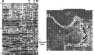
Despite the above difficulties, the production geologist will nevertheless try and find some basis for providing a predictive model for the subsurface geology of a fluvial reservoir. Seismic data can help to determine the planform geometry where it is of sufficient resolution (Figure 1). Fluvial geometries can sometimes be well differentiated on horizon slice amplitude displays (e.g., Brown et al.,[4] Rijks and Jauffred,[5] Noah et al.,[6] Carter[7]).
Meander belt reservoirs show different production behavior characteristics from braided river reservoirs; in the absence of seismic geomorphology evidence, the production geologist should intuitively pick the fluvial geometry type most likely to fit the available data and the reservoir performance. Perhaps because of the uncertainty involved in determining the planform geometry in fluvial reservoirs, the scenario approach (see Reservoir uncertainty) may be an appropriate tool to help evaluate fluvial reservoirs.
Geometry of meander belts
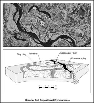
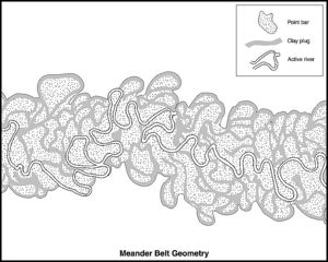
Meandering rivers deposit sand and mud within well-defined meander belts. The appearance of a meander belt in plan and cross section is of a complex labyrinth of interlocking sand bodies on the scale of hundreds of meters, embedded within varying volumes of mud (Figure 2). The mud can make up 50% or more of the volume. Channel features, where they survive, tend to be plugged with clay (Figure 2, Figure 3).
Gibling[10] provided data on width and thickness relationships for fluvial systems in various settings from Quaternary and older outcrops (Table 1). He found that meandering rivers do not generally create thick sedimentary packages. The maximum thickness for meandering river deposits in his database is only 38 m (124 ft), with 4–20 m (13–65 ft) as a common thickness range. Gibling makes the comment that despite their familiarity in the modern landscape, meandering river deposits probably constitute only a minor portion of the fluvial rock record by comparison to braided systems. This may be because the organized flow patterns associated with meandering rivers rarely persist for long periods.
| Depositional environment | Thickness | Width | Width/thickness ratio |
|---|---|---|---|
| Braided and low sinuousity rivers | 1-1200 m (3-3937 ft); most < 60 m (197 ft); common range 5-60 m (16-197 ft) | 50 m-1300+ km (164 ft-808+ mi); many > 1 km (0.62 mi); common range 0.5-10 km (0.3-6 mi) | 15-15,000+; some > 1000; common range 50-1000 |
| Meandering rivers | 1-38 m (3-125 ft); common range 4-20 m (13-65 ft) | 30 m-15 km (98 ft-9 mi); most < 3 km (1.8 mi); common range 0.3-3 km (0.1-1.8 mi) | 7-940; most < 250; many < 100; common range 30-250 |
| Delta distributaries | 1-35 m (3-115 ft); most < 20 m (65 ft); common range 3-20 m (10-65 ft) | 3 m-1 km (10 ft-0.6 mi); most < 500 m (1640 ft); common range 10-300 m (33-984 ft) | 2-245; most < 50; many < 15; common range 5-30 |
| Channels in eolian settings | 1-19 m (3-62 ft) | 2.5-1500 m (8.2-4921 ft); most < 150 m (492 ft) | 1-90; most < 15 |
| Valley fills on bedrock unconformities | 12-1400 m (39-4593 ft); most < 500 m (1640 ft) | 75 m-52 km (246 ft-32 mi); most < 10 km (6 mi) | 2-870; highly variable; mainly 2-100 |
| Valley fills within alluvial and marine strata | 2-210 m (6-689 ft); most < 60 m (197 ft) | 0.1-105 km (0.06-65 mi); common range 0.2-25 km (0.1-15 mi) | 4.6-3640; highly variable; common range 10-1000; many from 100 to 1000 |
| 1From Gibling[10], Journal of Sedimentary Research. Reprinted with permission from, and © by, the SEPM (Society for Sedimentary Geologists). | |||
Meandering fluvial macroforms
Macroforms found in meander belts include point bars, crevasse splays, and mud-rich channel plugs within a background of floodplain muds. Coals are found in fluvial systems with high water tables. Levees sometimes border rivers but they do not appear to be a major feature preserved in the subsurface.[10]
Point bars
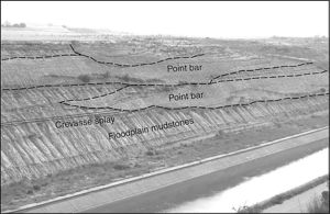
The main sand-prone macroforms found in meandering river sediments are point bars (Figure 4). These form by lateral accretion of sediment on the inside of meander bends, and they occur as discrete sand bodies with a lenticular or half-moon shape in plan view. A multitude of point bar sandstone bodies may be found studded within a meander belt.
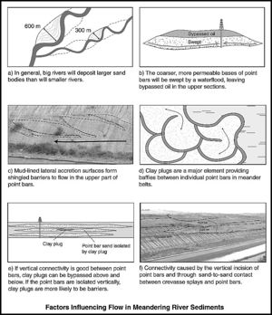
Jordan and Pryor[8] made detailed measurements on sediment body dimensions along a 10-mi (16-km) stretch of the Mississippi River meander belt system in southeastern Missouri. The point bars here are 15–45 m (49–147 ft) thick, a few kilometers long (typically 3 km; 2 mi), and between 600 and 1800 m (1968 and 5905 ft) wide. The Mississippi is a continental-size river stretching the length of the United States. As a general rule, big rivers like the Mississippi will tend to deposit large point bar sand bodies; lesser rivers will tend to produce smaller point bars (Figure 5a). For example, the typical width of individual point bars in the 35-1 sand of the Widuri field in the Java Sea is 1200-1500 m.[7] A well located in one of the point bars has produced 3.2MM bbls of oil. By contrast the fluvial sands in the Jonah Gas field of Wyoming are estimated to have a P50 width ranging from only 60 to 210 m.[11]
Several technical papers give cross plots of fluvial sand-body widths versus the maximum bankful depth of rivers (e.g., Bridge and Mackey[12]) These plots have been used to model thickness-to-width ratios for 3-D geological models.
Miall[13] criticized the use of empirical relationships for fluvial geometries in too prescriptive a manner. He suggests that they should only be used as approximate guidelines for developing alternative scenarios of fluvial reservoirs for modeling purposes. Shanley,[11] characterizing the Jonah field in Wyoming, preferred to estimate a range of possible dimensions for fluvial bodies instead of using a single unique value for the width-to-thickness ratio.
Werren et al.[14] described a vertical profile for a point bar deposit in the Cretaceous reservoir of the Little Creek field in Mississippi. An erosional base is overlain by channel lags with intraformational shale rip-up clasts. Above this are large-scale cross-bedded sandstones, which pass upward to beds showing horizontal and small-scale ripple cross laminae, clay drapes, micaceous and carbonaceous streaks, local mud balls, and intraclasts. The overall pattern is fining upward.
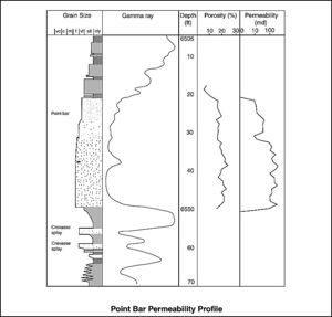
Fining-upward profiles are typical for point bars; the permeability declines upward with decreasing grain size (Figure 6). The decrease in permeability commonly occurs in a step-like fashion rather than showing a gradual upward decrease.
Upward-decreasing permeability profiles are unfavorable to efficient sweep. Water will flood through the high-permeability basal part of the point bar leaving the uppermost section unswept (Figure 5b).
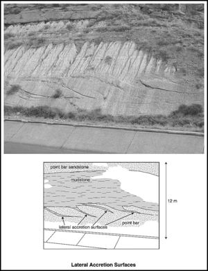
Sweep will be retarded where the upper sections of point bars form mud sheets along lateral accretion surfaces (Figure 5c, Figure 7). These are inclined surfaces formed by the lateral growth of the point bar as the meander loop migrates. Mud-lined lateral accretion surfaces develop by mud deposition during ponding at low river stages.[8] The inclined mud drapes form a series of shingled barriers to both vertical and horizontal flow.[16][17]
Detailed data integration analysis has been made for oil recovery from meander belt sandstones in the Daqing field in China.[18][19] After 30 yr of production from one of the reservoir units, the sweep efficiency is only 29.8%. It was found that although the basal intervals of the fluvial sandstones are well swept, there is much oil left behind in the upper part. Water cuts in the production wells can reach 90% with only the basal section of the fluvial sandstones contacted by the waterflood. A horizontal well was drilled as a pilot trial to determine whether this could recover the oil in the upper sections of the point bar sandstones. The well found an estimated net pay of 2–4 m (7–13 ft) but produced less than expected as a result of a combination of formation damage and poorer than predicted vertical permeability.[19]
Meander belt sediments may be better suited as gas reservoirs than oil reservoirs. The labyrinth of numerous dead ends in these systems will not tend to trap nearly so much gas as oil. The expansion of gas on the reduction of pressure with depletion will cause much of the gas to spill out of the dead ends in fluvial reservoirs. Gas can also flow through the low-permeability connections that exist in fluvial systems, which would otherwise not allow oil to pass.
Crevasse splays
Crevasse splays are sandy overbank deposits, which are found intercalated with background floodplain muds. They form fan-shaped sheets, tens to hundreds of meters wide and typically 0.3–2 m (1–6.5 ft) thick. Mjos et al.[20] gave a width-to-thickness ratio for crevasse splays of 150–1000. The splays thin laterally toward the margins of the floodplain.[21] Individual flows may amalgamate into thicker composite intervals.
Crevasse splays do not normally contain large volumes of hydrocarbons, although they may provide a target for infill wells onshore. Ambrose et al.[22] noted that crevasse splays in the meander belt reservoir of the La Gloria gas field in Texas were only partially depleted or undepleted. These have limited lateral extent and pinch out less than 460 m (1509 ft) along depositional strike from the channel fill deposits. The crevasse splays are often found with much higher pressures than the main producing intervals in the field. Nevertheless, they deplete rapidly on production, indicating that they contain only small, isolated volumes of gas. However, the overall production potential is thought to be significant as these splay compartments are numerous.
Mud plugs
Fluvial reservoirs may be partially or totally compartmentalized by abandoned channel mud plugs.[22] A meander loop can be cut off by the river breaking through into a new course during a flood. The abandoned meander channel is quickly isolated from the river flow, typically forming lakes and ponds for a period of time. The channels slowly fill up with clay, silt, and peaty organic material.
Mud plugs are crescentic in plan view and lenticular in cross section. They are narrow with widths of tens to hundreds of meters. In the Widuri field, offshore Java, mud plugs are described as 50–150 m (164–492 ft) wide and up to 5 m (16 ft) thick.[7] A meander belt may contain many individual mud plugs, which can collectively make up a large volume of the total system. In a study area comprising 16 billion m3 of a meander belt in the modern day Mississippi River, Jordan and Pryor[8] estimated that 11.1 billion m3 of this volume comprises point bar and splay sandstones and the remaining 4.9 billion m3 consists of clay plugs within numerous abandoned channels.
Clay plugs can be difficult to recognize in the subsurface. It is sometimes possible to identify them on correlation panels if the wells are closely spaced. They can also be picked out from amplitude displays on good quality seismic data.
Connectivity in meander belts
Determining the connectivity of the sand bodies in a meander belt system is critical to evaluating the commerciality of types of reservoirs. Individual point bars are relatively small reservoir bodies likely to contain only a few million barrels of recoverable oil at best. They may be successfully drilled onshore where wells are relatively cheap, but they are less likely to make much profit as a primary target offshore. However, if several of these sand bodies overlap with each other, then they can combine to form a larger connected sand volume.
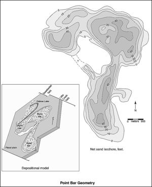
Technical papers indicate that connectivity in meander belt sediments can be highly variable and prone to chance factors. An example of this is the Little Creek field in Mississippi.[14] The lower reservoir unit comprises three connected point bar sandstones (Figure 8). The Sweetwater field immediately to the north is believed to form part of the same fluvial system and produces from a fourth point bar sand body along the same trend. Nevertheless, the Sweetwater field is isolated from the Little Creek field on the evidence of a 24-m (79-ft) higher oil-water contact. The two fields are thought to be separated by a shale plug or an area with relatively high capillary displacement pressure. A similar observation was made by Carter[7] for a meander belt reservoir in the Widuri field in the Java Sea. Following the depletion of a well on the updip side of a 100-m (328-ft)-wide abandoned channel, a second well was drilled on the opposite site of the clay plug. A full oil column was found in the new well, unaffected by production from the previous well. In the Saddle Lake area of Alberta, Canada, oil and gas pools are restricted to point bars completely surrounded by clay plugs.[23]
It seems from these case examples that clay plugs can be an important element limiting horizontal connectivity in meander belt sediments (Figure 5d). Some point bars show flow connectivity with each other, others do not. Connectivity may be effective where the clay plug does not totally separate two point bars areally. Richardson et al.[24] noted that there is commonly some sand or gravel underneath clay plugs that can allow communication. Similar observations have been made by Donselaar and Overeem.[25] Clay plugs occur at the same level of the point bar that it partially encloses. If vertical connectivity is effective between incised point bars, the clay plug obstruction can be bypassed above and below. If no effective vertical communication occurs, then clay plugs are more likely to act as lateral flow barriers (Figure 5e).
What outcrops of meander belt sediments indicate about connectivity
Well-exposed outcrops of meander belt sediments can be used to get an understanding of the reservoir connectivity in three dimensions. Connectivity can result from the vertical incision of one point bar into an older underlying point bar, creating multistory sand bodies (Figure 5f). Point bars commonly connect with each other across the shallow, sandy course of the river where the tips of point bars overlap on opposite banks. Crossovers like this can create a connected system of point bars which Donselaar and Overeem[25] describe as a string-of-beads sandstone body. Crevasse splays may also link up one point bar with another.
Nevertheless, it probably does not take much for the connectivity between the various sand bodies in a meander belt to be disrupted. The connections between the various macroforms are likely to be through apertures of limited cross-sectional area such as erosional windows, crossovers, and crevasse splay-point bar intersections. Carbonate cementation of the basal lag by circulating groundwater can create permeability barriers at the base of individual point bars. Precipitation of carbonate cement may be accentuated where calcrete fragments form part of the basal lag.[26]
Abundant mud chips caked along the base of point bars have the potential to attenuate communication. For example, Chapin and Mayer[15] found that the vertical connectivity between stacked point bars was severely impeded by mudstone-rich lags at the base of individual point bars in the reservoir of the Peoria field in Colorado. Doyle and Sweet[27] found that mudclast lags at the base of point bar sandstones have a patchy distribution in the Gypsy Sandstone of Northern Oklahoma. They consider them more likely to form baffles to flow instead of continuous barriers. Shanley[11] noted that where basal lags contain abundant mudclasts, they can be mistaken for shales on the gamma-ray log. Caution should be taken where a shale-like wireline log response is seen within thick multistory fluvial sandstones.
Coals commonly act as significant flow barriers where they occur in more humid fluvial systems. The precursor peat deposits to coal occur as thick mats of flexible and intertwined plant material and these can withstand strong erosive forces to stay substantially intact.
The effect of faulting on connectivity in meander belt sediments
Small faults can create vertical connections across the fault plane between sand bodies in high net-to-gross intervals. Where low net-to-gross fluvial sediments are dissected by faults, this can significantly reduce connectivity. The reduced degree of sand-to-sand juxtaposition across faults is the controlling factor.[28] The potential for clay smear and sealing faults will also be high particularly in low net-to-gross fluvial systems (Table 2).
| Characteristic | Favorable for reservoir development | Unfavorable for reservoir development |
|---|---|---|
| Large rivers | Larger point bars with larger in-place volumes | - |
| Small rivers | - | Smaller point bars with smaller in-place volumes |
| Upward-decreasing permeability profiles | - | Poor sweep caused by water contacting the basal section only |
| Mud-lined lateral accretion surfaces present | - | They form shingled barriers to flow in the upper part of point bars |
| Gas reservoir | Heterogeneity and low-permeability connectivity less of a factor with gas | - |
| Mud plugs | - | Can act as lateral barriers to isolate individual point bars and create low volume compartments |
| Multistory sand bodies | Composite sand bodies with larger volumes | - |
| Single-story sand bodies with poor to no vertical permeability | - | Single sand bodies with small in-place volumes |
| Basal lags have good vertical permeability | Allows connectivity between superimposed macroforms | - |
| Basal lags are cemented or are caked with clay chips | - | Poor to no connectivity between superimposed macroforms |
| Coals present | Can act as permeability barriers to vertical flow | - |
| High density of faulting | Small faults can create connectivity in layered sandy fluvial systems | Likely to create numerous, small, marginal to uncommercial reservoir compartments in low net-to-gross systems |
See also
- Eolian reservoirs
- Braided fluvial reservoirs
- Deltaic reservoirs
- Siliciclastic shorelines and barrier island reservoirs
- Deep-water marine reservoirs
- Carbonate reservoir
References
- ↑ Bridge, J. S., 2003, Rivers and flood plains: Forms, processes and sedimentary record: Oxford, Blackwell, 491 p.
- ↑ Friend, P. F., M. J. Slater, and R. C. Williams, 1979, Vertical and lateral building of river sandstone bodies, Ebro Basin, Spain: Journal of the Geological Society of London, v. 136, p. 39–46.
- ↑ Burnett, M., 1996, 3-D seismic expression of a shallow fluvial system in west central Texas, in P. Weimer and T. L. Davis, eds.: AAPG Studies in Geology 42 and SEG (Society of Exploration Geophysicists) Geophysical Developments Series 5, p. 45–56.
- ↑ Brown, A. R., C. G. Dahm, and R. J. Graebner, 1981, A stratigraphic case history using three-dimensional seismic data in the Gulf of Thailand: Geophysical Prospecting, v. 29, no. 3, p. 327–349.
- ↑ Rijks, E. J. K., and J. C. E. M. Jauffred, 1991, Attribute extraction: An important application in any detailed 3D interpretation study: Leading Edge, v. 10, no. 9, p. 11–19.
- ↑ Noah, J. T., G. S. Hofland, and K. Lemke, 1992, Seismic interpretation of meander channel point-bar deposits using realistic seismic modeling techniques: The Leading Edge, v. 11, p. 13–18.
- ↑ 7.0 7.1 7.2 7.3 Carter, D. C., 2003, 3-D seismic geomorphology: Insights into fluvial reservoir deposition and performance, Widuri field, Java Sea: AAPG Bulletin, v. 87, no. 6, p. 909–934. Cite error: Invalid
<ref>tag; name "Carter_2003" defined multiple times with different content - ↑ 8.0 8.1 8.2 8.3 Jordan, D. W., and W. A. Pryor, 1992, Hierarchical levels of heterogeneity in a Mississippi river meander belt and application to reservoir systems: AAPG Bulletin, v. 76, no. 10, p. 1601–1624. Cite error: Invalid
<ref>tag; name "Jordanandpryor_1992" defined multiple times with different content - ↑ Sun, T., P. Meakin, T. Jossang, and K. Schwarz, 1996, A simulation model of meandering rivers: Water Resources Research, v. 32, pt. 9, p. 2937–2954.
- ↑ 10.0 10.1 10.2 Gibling, M. R. 2006, Width and thickness of fluvial channel bodies and valley fills in the geological record: A literature compilation and classification: Journal of Sedimentary Research, v. 76, p. 731–770.
- ↑ 11.0 11.1 11.2 Shanley, K. W., 2004, Fluvial reservoir description for a giant, low-permeability gas field: Jonah field, Green River Basin, Wyoming, U.S.A., in J. W. Robinson and K. W. Shanley, eds., Jonah field: Case study of a giant tight-gas fluvial reservoir: AAPG Studies in Geology 52, p. 159–182.
- ↑ Bridge, J. S., and S. D. Mackey, 1993, A theoretical study of fluvial sandstone body dimensions, in S. S. Flint and I. D. Bryant, eds., Geological modeling of hydrocarbon reservoirs: International Association of Sedimentologists, Special Publication 15, p. 213–236.
- ↑ Miall, A. D., 2006, Reconstructing the architecture and sequence stratigraphy of the preserved fluvial record as a tool for reservoir development: A reality check: AAPG Bulletin, v. 90, no. 7, p. 989–1002.
- ↑ 14.0 14.1 Werren, E. G., R. D. Shew, E. R. Adams, and R. J. Stancliffe, 1990, Meander-belt reservoir geology, mid-dip Tuscaloosa, Little Creek field, Mississippi, in J. H. Barwis, J. G. McPherson, and R. J. Studlick, eds., Sandstone petroleum reservoirs: Berlin, Springer, p. 85–107.
- ↑ 15.0 15.1 Chapin, M. A., and D. F. Mayer, 1991, Constructing a three-dimensional rock property model of fluvial sandstones in the Peoria field, Colorado, in A. D. Miall and N. Tyler, eds., The three dimensional facies architecture of terrigenous clastic sediments and its implication for hydrocarbon discovery and recovery: SEPM Concepts in Sedimentology and Paleontology 3, p. 160–171.
- ↑ Ma, S., J. Zhang, N. Jin, and Z. Wang, 1999, The 3-D architecture of point bar and the forming and distribution of remaining oil: Presented at the Society of Petroleum Engineers Asia Pacific Improved Oil Recovery Conference, October 25–26, Kuala Lumpur, Malaysia, SPE Paper 57308, 7 p.
- ↑ Pranter, M. J., A. I. Ellison, R. D. Cole, and P. E. Patterson, 2007, Analysis and modeling of intermediate-scale reservoir heterogeneity based on a fluvial point-bar outcrop analog, Williams Fork Formation, Piceance Basin, Colorado: AAPG Bulletin, v. 91, no. 7, p. 1025–1051.
- ↑ Xue, P., 1986, A point bar facies reservoir model—Semi-communicated sand body: Presented at the International Meeting on Petroleum Engineering, Society of Petroleum Engineers, March 17–20, Beijing, China, SPE Paper 14837, 13 p.
- ↑ 19.0 19.1 Fu, Z., Q. Du, P. Zhang, B. Ji, and W. Lu, 1998, Improving recovery efficiency of water-drive channel sandstone reservoir by drilling horizontal wells laterally: Presented at the Society of Petroleum Engineers International Conference on Horizontal Well Technology, November 1–4, Calgary, Alberta, Canada, SPE Paper 50392, 3 p.
- ↑ Mjos, R., O. Walderhaug, and E. Prestholm, 1993, Crevasse splay sandstone geometries in the Middle Jurassic Ravenscar Group of Yorkshire, UK, in M. Marzo and C. Puigdefabregas, eds., Alluvial sedimentation: Special Publication of the International Association of Sedimentologists 17, p. 167–184.
- ↑ Miall, A. D., 1996, The geology of fluvial deposits: Berlin, Springer-Verlag, 582 p.
- ↑ 22.0 22.1 Ambrose, W. A., N. Tyler, and M. J. Parsley, 1991, Facies heterogeneity, pay continuity, and infill potential in barrier-island, fluvial, and submarine-fan reservoirs: Examples from the Texas Gulf Coast and Midland Basin, in A. D. Miall and N. Tyler, eds., The three-dimensional facies architecture of terrigenous clastic sediments and its implication for hydrocarbon discovery and recovery: SEPM Concepts in Sedimentology and Paleontology 3, p. 13–21.
- ↑ Edie, R. W., and J. M. Andrichuk, 2003, Meander belt entrapment of hydrocarbons at Saddle Lake, Alberta and an untested in situ combustion scheme for recovery of heavy oil: Bulletin of Canadian Petroleum Geology, v. 51, no. 3, p. 253–274.
- ↑ Richardson, J. G., J. B. Sangree, and R. M. Sneider, 1987, Meandering stream reservoirs: Journal of Petroleum Technology, v. 39, no. 12, p. 1501–1502.
- ↑ 25.0 25.1 Donselaar, M. E., and I. Overeem, 2008, Connectivity of fluvial point bar deposits: An example from the Miocene Huesca fluvial fan, Ebro basin, Spain: AAPG Bulletin, v. 92, no. 9, p. 1109–1129.
- ↑ Mckie, T., and P. Audretsch, 2005, Depositional and structural controls on Triassic reservoir performance in the Heron cluster, ETAP, central North Sea, in A. G. Dore and B. A. Vining, eds., Petroleum geology: Northwest Europe and global perspectives: Proceedings of the 6th Petroleum Geology Conference, Geological Society (London), p. 285–297.
- ↑ Doyle, J. D., and M. L. Sweet, 1995, Three-dimensional distribution of lithofacies, bounding surfaces, porosity, and permeability in a fluvial sandstone—Gypsy Sandstone of northern Oklahoma: AAPG Bulletin, v. 79, no. 1, p. 70–95.
- ↑ Bailey, W. R., T. Manzocchi, J. J. Walsh, K. Keogh, D. Hodgetts, J. Rippon, P. A. R. Nell, S. Flint, and J. A. Strand, 2002, The effect of faults on the 3-D connectivity of reservoir bodies: A case study from the East Pennine coalfield, UK: Petroleum Geoscience, v. 8, no. 3, p. 263–277.
