Difference between revisions of "Sedimentary basin analysis"
| Line 37: | Line 37: | ||
* [[Depositional systems tracts]] | * [[Depositional systems tracts]] | ||
* [[Minibasins and petroleum systems]] | * [[Minibasins and petroleum systems]] | ||
| − | * [[ | + | * [[Exploration strategy for deepwater sands]] |
==Index maps for GOM example== | ==Index maps for GOM example== | ||
Revision as of 17:01, 10 March 2014
| Exploring for Oil and Gas Traps | |

| |
| Series | Treatise in Petroleum Geology |
|---|---|
| Part | Critical elements of the petroleum system |
| Chapter | Sedimentary basin analysis |
| Author | John M. Armentrout |
| Link | Web page |
| Store | AAPG Store |
Sedimentary basin analysis involves studying the history of sediment accumulation within depocenters and the tectonic processes that create the basin depression, influence the distribution of sediments, and deform the contained rocks. Aspects of basin analysis, as presented in this chapter, focus on several scales:
- Plate tectonic/basin—geographic area of crustal subsidence and its sedimentary fill
- Subbasin depocenter—locus of sediment accumulation
- Depositional sequence—sediment accumulated during one depositional cycle
- Local basins—local structural and stratigraphic compartments within a depocenter
Understanding the local basin—achieved through integrating stratigraphic, structural, biostratigraphic, and geochemical data—is the critical scale of basin analysis for petroleum system identification. Reconstructing a basin's history, from regional tectonic setting to a single local basin, provides the geologic framework for defining exploration plays and prospects.
Example: Gulf of Mexico basin
The Gulf of Mexico (GOM) basin is used as the example of sedimentary basin analysis and the relationship of basin analysis to defining essential elements and processes of the petroleum system. By using only one example, the reader should be better able to focus on the process of data integration, which can be adapted or modified for other basin types. Aspects of plate tectonics and depositional history are used to define several scales of subbasinal entities and their relationship to petroleum source and reservoir rocks. A history of progressive growth faulting and salt mobility controls the formation of potential traps, the locus of sediment transport and accumulation, and potential avenues of hydrocarbon migration and accumulation.
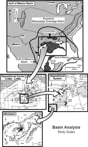
This section of articles progress from largest scale to smallest scale (Figure 1). It begins with the entire GOM basin and concludes with a case history of the East Breaks minibasin petroleum system. The East Breaks minibasin is an example of play and prospect definition within the context of a subregional petroleum system within one subprovince of the GOM Tertiary basin.
See also
- Defining the basin framework
- Depocenters
- Depositional sequences
- Depositional systems tracts
- Minibasins and petroleum systems
- Exploration strategy for deepwater sands
Index maps for GOM example
Figure 1 is a series of index maps for the GOM basin analysis example used in this section of articles. Each map represents a different scale of sedimentary basin analysis, beginning with the largest (the GOM basin) and progressing to the smallest (the East Breaks minibasin).
