Difference between revisions of "Petrophysical analysis of lithofacies"
Cwhitehurst (talk | contribs) |
Cwhitehurst (talk | contribs) m (added Category:Treatise Handbook 3 using HotCat) |
||
| (13 intermediate revisions by 2 users not shown) | |||
| Line 6: | Line 6: | ||
| part = Predicting the occurrence of oil and gas traps | | part = Predicting the occurrence of oil and gas traps | ||
| chapter = Exploring for stratigraphic traps | | chapter = Exploring for stratigraphic traps | ||
| − | | frompg = 21- | + | | frompg = 21-46 |
| − | | topg = 21- | + | | topg = 21-48 |
| author = John C. Dolson, Mike S. Bahorich, Rick C. Tobin, Edward A. Beaumont, Louis J. Terlikoski, Michael L. Hendricks | | author = John C. Dolson, Mike S. Bahorich, Rick C. Tobin, Edward A. Beaumont, Louis J. Terlikoski, Michael L. Hendricks | ||
| link = http://archives.datapages.com/data/specpubs/beaumont/ch21/ch21.htm | | link = http://archives.datapages.com/data/specpubs/beaumont/ch21/ch21.htm | ||
| Line 14: | Line 14: | ||
| isbn = 0-89181-602-X | | isbn = 0-89181-602-X | ||
}} | }} | ||
| − | The reservoir or seal quality of a rock is established soon after deposition. It is strongly influenced by its environment of deposition. Diagenesis can alter or completely change the original pore space of a rock, especially for carbonates. However, if the original pore space is not altered too much, then a relationship exists between lithofacies and reservoiror seal-quality rocks that we can use when prospecting for stratigraphic traps. A petrophysical analysis of the lithofacies of a rock section in a target area can help determine if such a relationship exists. | + | The reservoir or seal quality of a rock is established soon after deposition. It is strongly influenced by its environment of deposition. Diagenesis can alter or completely change the original pore space of a rock, especially for carbonates. However, if the original pore space is not altered too much, then a relationship exists between [[lithofacies]] and reservoiror seal-quality rocks that we can use when prospecting for stratigraphic traps. A petrophysical analysis of the lithofacies of a rock section in a target area can help determine if such a relationship exists. |
==Procedure== | ==Procedure== | ||
| − | |||
| − | + | [[file:exploring-for-stratigraphic-traps_fig21-31.png|300px|thumb|{{figure number|1}}Live oil stain in macroporous strata indicates the direction to move updip.]] | |
| − | | | ||
| − | |||
| − | |||
| − | | | ||
| − | | 1 | ||
| − | |||
| − | |||
| − | |||
| − | |||
| − | |||
| − | |||
| − | |||
| − | |||
| − | + | After lithofacies analysis, a careful petrophysical analysis of shows and production should be made and compared to lithofacies distribution. The table below suggests a procedure for petrophysical analysis. | |
| − | |||
| − | |||
| − | |||
| − | |||
| − | |||
| − | |||
| − | |||
| − | |||
| − | |||
| − | |||
| − | |||
| − | |||
| − | |||
| − | |||
| − | |||
| − | |||
| − | |||
| − | |||
| − | |||
| − | |||
| − | |||
| − | |||
| − | |||
| − | [[ | + | # Gather all available fluid data regarding production, shows, and pressures from prospective intervals. |
| + | # On structural [[cross section]]s, plot intervals that … | ||
| + | #* Were perforated | ||
| + | #* Had DSTs | ||
| + | #* Had RSTs | ||
| + | #* Had mud log shows | ||
| + | ## Annotate the intervals with the results. | ||
| + | # Divide potential reservoir units on the cross sections into intervals of similar petrophysical character (flow units) using log data and, if available, porosity-[[permeability]] data. Categorize each flow unit by port type as mega-, macro-, meso-, or microporous. | ||
| + | # Calculate water saturation (S<sub>w</sub> ) of intervals that … | ||
| + | #* Are productive | ||
| + | #* Had shows | ||
| + | #* Are potential reservoirs | ||
| + | ## Annotate the log intervals with S<sub>w</sub> values. | ||
| + | # Estimate the height above free water for zones that appear to have oil or gas. | ||
| + | # Analyze the fluid data in the context of the petrophysical data. | ||
| + | #* Do S<sub>w</sub> values, shows, and fluid pressures make sense in context with other geological data, including [[hydrocarbon column]] height? | ||
| + | #* Do the shows or S<sub>w</sub> values indicate the presence of an updip or downdip trap? | ||
| + | # Determine whether a relationship exists between the development of reservoir-quality rocks, seal-quality rocks, and lithofacies that can be used to predict location and economic viability of prospective traps. | ||
==Example: calibrating logs to cores and shows== | ==Example: calibrating logs to cores and shows== | ||
| − | [[file:exploring-for-stratigraphic-traps_fig21-32.png|thumb|{{figure number|2}}. Copyright: Putnam and Oliver, 1980 | + | [[file:exploring-for-stratigraphic-traps_fig21-32.png|300px|thumb|{{figure number|2}}Two distinct pressure regimes coinciding with discrete channel systems, delineated with pressure-depth plots. Copyright: Putnam and Oliver;<ref>Putnam, P. E., and T. A. Oliver, 1980, Stratigraphic traps in channel sandstones in the Upper Mannville (Albian) of east-central Alberta: Canadian Society of Petroleum Geologists Bulletin, vol. 28, p. 489–508.</ref> courtesy Canadian Society of Petroleum Geologists. Map courtesy Eric Dahlberg.]] |
| − | Posting core [[porosity]], permeability, and pore throat radius (r<sub>35</sub>) data directly on wireline logs next to lithofacies descriptions and show data helps us decide about exploitation for stratigraphic traps. In [[:file:exploring-for-stratigraphic-traps_fig21-31.png|Figure 1]], the live oil stain in macroporous strata indicates the direction to move updip. The only macroporous strata present is within an algal mound facies developed in this parasequences at relative highstand. Microporous dolomites comprising the lower portions of the parasequences have poor reservoir characteristics, despite high porosity readings on the logs. Thus, the target of interest is the highstand mound facies. | + | Posting core [[porosity]], permeability, and pore throat radius ([[Characterizing_rock_quality#What_is_r35.3F|r<sub>35</sub>]]) data directly on wireline logs next to lithofacies descriptions and show data helps us decide about exploitation for stratigraphic traps. In [[:file:exploring-for-stratigraphic-traps_fig21-31.png|Figure 1]], the live oil stain in macroporous strata indicates the direction to move updip. The only macroporous strata present is within an algal mound facies developed in this parasequences at relative highstand. Microporous dolomites comprising the lower portions of the parasequences have poor reservoir characteristics, despite high porosity readings on the logs. Thus, the target of interest is the highstand mound facies. |
==Example: using pressures== | ==Example: using pressures== | ||
| Line 73: | Line 53: | ||
==See also== | ==See also== | ||
| − | * [[ | + | * [[Seismic facies analysis]] |
* [[Basics of seismic facies analysis]] | * [[Basics of seismic facies analysis]] | ||
* [[Reflection configuration patterns]] | * [[Reflection configuration patterns]] | ||
| Line 80: | Line 60: | ||
* [[Techniques for enhancing seismic facies analysis]] | * [[Techniques for enhancing seismic facies analysis]] | ||
* [[Analyzing lithofacies]] | * [[Analyzing lithofacies]] | ||
| + | * [[Lithofacies]] | ||
==References== | ==References== | ||
| Line 91: | Line 72: | ||
[[Category:Predicting the occurrence of oil and gas traps]] | [[Category:Predicting the occurrence of oil and gas traps]] | ||
[[Category:Exploring for stratigraphic traps]] | [[Category:Exploring for stratigraphic traps]] | ||
| + | [[Category:Treatise Handbook 3]] | ||
Latest revision as of 18:53, 4 February 2022
| Exploring for Oil and Gas Traps | |

| |
| Series | Treatise in Petroleum Geology |
|---|---|
| Part | Predicting the occurrence of oil and gas traps |
| Chapter | Exploring for stratigraphic traps |
| Author | John C. Dolson, Mike S. Bahorich, Rick C. Tobin, Edward A. Beaumont, Louis J. Terlikoski, Michael L. Hendricks |
| Link | Web page |
| Store | AAPG Store |
The reservoir or seal quality of a rock is established soon after deposition. It is strongly influenced by its environment of deposition. Diagenesis can alter or completely change the original pore space of a rock, especially for carbonates. However, if the original pore space is not altered too much, then a relationship exists between lithofacies and reservoiror seal-quality rocks that we can use when prospecting for stratigraphic traps. A petrophysical analysis of the lithofacies of a rock section in a target area can help determine if such a relationship exists.
Procedure
After lithofacies analysis, a careful petrophysical analysis of shows and production should be made and compared to lithofacies distribution. The table below suggests a procedure for petrophysical analysis.
- Gather all available fluid data regarding production, shows, and pressures from prospective intervals.
- On structural cross sections, plot intervals that …
- Were perforated
- Had DSTs
- Had RSTs
- Had mud log shows
- Annotate the intervals with the results.
- Divide potential reservoir units on the cross sections into intervals of similar petrophysical character (flow units) using log data and, if available, porosity-permeability data. Categorize each flow unit by port type as mega-, macro-, meso-, or microporous.
- Calculate water saturation (Sw ) of intervals that …
- Are productive
- Had shows
- Are potential reservoirs
- Annotate the log intervals with Sw values.
- Estimate the height above free water for zones that appear to have oil or gas.
- Analyze the fluid data in the context of the petrophysical data.
- Do Sw values, shows, and fluid pressures make sense in context with other geological data, including hydrocarbon column height?
- Do the shows or Sw values indicate the presence of an updip or downdip trap?
- Determine whether a relationship exists between the development of reservoir-quality rocks, seal-quality rocks, and lithofacies that can be used to predict location and economic viability of prospective traps.
Example: calibrating logs to cores and shows

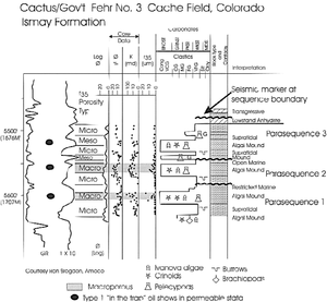
Posting core porosity, permeability, and pore throat radius (r35) data directly on wireline logs next to lithofacies descriptions and show data helps us decide about exploitation for stratigraphic traps. In Figure 1, the live oil stain in macroporous strata indicates the direction to move updip. The only macroporous strata present is within an algal mound facies developed in this parasequences at relative highstand. Microporous dolomites comprising the lower portions of the parasequences have poor reservoir characteristics, despite high porosity readings on the logs. Thus, the target of interest is the highstand mound facies.
Example: using pressures
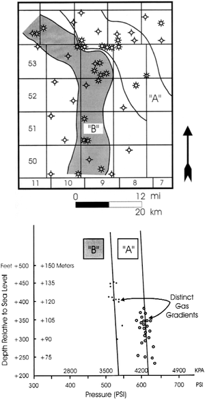
Reservoir scale discontinuities often cannot be detected by primary trapping geometries from sequence stratigraphy alone. Within channel systems of the Lower Cretaceous Mannville Group (Alberta, Canada), fluids distributions may be complex. High-resolution definition of the discrete traps may be possible only by integrating more data.
Figure 2 shows two distinct pressure regimes coinciding with discrete channel systems, delineated with pressure-depth plots. For additional information, refer to Dahlberg.[2]
See also
- Seismic facies analysis
- Basics of seismic facies analysis
- Reflection configuration patterns
- Seismic facies mapping
- Analyzing individual reflectors
- Techniques for enhancing seismic facies analysis
- Analyzing lithofacies
- Lithofacies
References
- ↑ Putnam, P. E., and T. A. Oliver, 1980, Stratigraphic traps in channel sandstones in the Upper Mannville (Albian) of east-central Alberta: Canadian Society of Petroleum Geologists Bulletin, vol. 28, p. 489–508.
- ↑ Dahlberg, E., C., 1982, Applied Hydrodynamics in Petroleum Exploration: New York, Springer-Verlag, 161 p.
