Difference between revisions of "Mandal-Ekofisk(!) petroleum system"
FWhitehurst (talk | contribs) |
FWhitehurst (talk | contribs) |
||
| Line 28: | Line 28: | ||
[[file:petroleum-systems_fig3-8.png|300px|thumb|{{figure number|2}}Modified from Cornford.<ref name=ch03r3 />]] | [[file:petroleum-systems_fig3-8.png|300px|thumb|{{figure number|2}}Modified from Cornford.<ref name=ch03r3 />]] | ||
| − | The petroleum system map in [[:file:petroleum-systems_fig3-8.png|Figure 2]] shows the pod of active source rock and the oil and gas | + | The petroleum system map in [[:file:petroleum-systems_fig3-8.png|Figure 2]] shows the pod of active source rock and the oil and gas [[accumulation]]s that were charged by this same pod of active source rock; all are within the geographic or known extent of the system. Most accumulations for the Mandal-Ekofisk(!) overly the active source rock, and the gas/condensate fields overlie the most mature source rock. |
==Petroleum system cross section== | ==Petroleum system cross section== | ||
Revision as of 20:00, 22 July 2014
| Exploring for Oil and Gas Traps | |

| |
| Series | Treatise in Petroleum Geology |
|---|---|
| Part | Traps, trap types, and the petroleum system |
| Chapter | Petroleum systems |
| Author | Leslie B. Magoon, Edward A. Beaumont |
| Link | Web page |
| Store | AAPG Store |
The Mandal-Ekofisk(!) petroleum system in the Central Graben of the North Sea contains 21.4 billion bbl of oil and 39.4 trillion ft3 of gas in 39 fields.[1] The age of the reservoir rock ranges from Devonian to Tertiary age with about 85% of the petroleum in rock adjacent to the Cretaceous-Tertiary boundary, specifically the Ekofisk Formation of Late Cretaceous age. Based on geochemical evidence, the Upper Jurassic (Kimmeridgian) to Lower Cretaceous source rock is the Mandal Formation. A positive oil-source rock correlation indicates a known system.
Geologic setting[edit]
This petroleum system formed in sedimentary rocks deposited in a failed rift system in the North Sea between Great Britain, Norway, and Denmark. The prerift rocks are mostly underburden rocks and are not involved in this petroleum system except as reservoir rocks for a minor amount of petroleum. The synrift sedimentary section contains the source rock. The reservoir rock, seal rock, and overburden rock were deposited during the postrift period of sedimentation.
Burial history chart[edit]
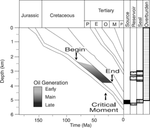
To better determine when the Mandal source rock was actively generating petroleum, a burial history chart (Figure 1) was constructed. Based on this and other charts, peak generation of petroleum occurred at about 30 Ma, selected as the critical moment.
Petroleum system map[edit]
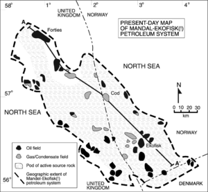
The petroleum system map in Figure 2 shows the pod of active source rock and the oil and gas accumulations that were charged by this same pod of active source rock; all are within the geographic or known extent of the system. Most accumulations for the Mandal-Ekofisk(!) overly the active source rock, and the gas/condensate fields overlie the most mature source rock.
Petroleum system cross section[edit]
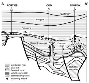
The petroleum system cross section in Figure 3 shows migration pathways and the spatial relation of the active source rock to the reservoir rocks. This section trends longitudinally (see Figure 2 for location) along the Central Graben and shows the vertical migration path from the active source rock through the Cretaceous rocks and horizontally along the basal Paleogene reservoir rocks until it accumulates in various traps. The underburden rock is pre-Late Jurassic in age and is not involved in the petroleum system except as minor reservoir rocks and where the Permian salt (Zechstein Group) creates diapirs that form petroleum traps and migration paths in fractured chalk.
Oil-source rock correlation[edit]
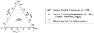
The oil-source rock correlation is a multiparameter geochemical approach; biological markers are one parameter. Biological marker analysis by Mackenzie et al.[2] and Hughes et al.[3] from reservoirs in the Greater Ekofisk, Forties, Montrose, and Argyll fields shows that these oils originated from the Mandal Formation source rock, as illustrated in Figure 4.
Petroleum system events chart[edit]
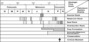
An events chart indicates when the essential elements and processes took place to form a petroleum system, the critical moment, and the preservation time. In Figure 5, the source rock is the Upper Jurassic to Lower Cretaceous Mandal Formation, which was deposited as the rift formed. Most overburden rock of Cretaceous to Cenozoic age was deposited after the rift formed. The seal rock ranges from Permian to Neogene and consists of halite, shale, and chalk. Based on volume of petroleum, the Permian to Jurassic reservoir rocks are least important; the most important reservoir rocks are Late Cretaceous to early Paleogene in age. Most traps were created as the rift formed and filled through structural movement and halokenesis. Petroleum generation-migration-accumulation occurred from just over 100 Ma to the present day. The critical moment, or peak generation, is at 30 Ma.
Size of the petroleum system[edit]
The size of the Mandal-Ekofisk(!) petroleum system, as shown in the table below, is determined by the total volume of in-place hydrocarbons that originated from the pod of active Mandal source rock. The in-place hydrocarbons are determined from the recoverable hydrocarbons and, where possible, surface deposits, seeps, and shows.
| Field name | OIP, × 106 bbl | OIP, × 106 m3 | Cond, × 106 bbl | Cond, × 106 m3 | GIP, × 106 bbl | GIP, × 106 m3 |
|---|---|---|---|---|---|---|
| Acorn | — | — | — | — | — | — |
| Albuskjell | — | — | 67 | 11 | 848 | 24 |
| Arbroath | 340 | 54 | — | — | 83 | 2 |
| Argyl | 218 | 35 | — | — | 257 | 7 |
| Auk | 517 | 82 | — | — | 98 | 3 |
| Beechnut | — | — | — | — | — | — |
| Clyde | 405 | 64 | — | — | 138 | 4 |
| Cod | — | — | 21 | 3 | 489 | 14 |
| Duncan | 49 | 8 | — | — | 69 | 2 |
| Edda | 114 | 18 | — | — | 353 | 10 |
| Ekofisk | 7,099 | 1,129 | 404 | 64 | 21,189 | 600 |
| Eldfisk | 1,589 | 253 | — | — | 7,249 | 205 |
| Erskine | — | — | — | — | — | — |
| Flyndra | — | — | — | — | — | — |
| Forties | 4,333 | 689 | — | — | 1,313 | 37 |
| Fulmar | 812 | 129 | — | — | 499 | 14 |
| Gannet | 800 | 127 | — | — | 1,000 | 28 |
| Gert | — | — | — | — | — | — |
| Gyda | — | — | — | — | — | — |
| Hod | 236 | 38 | — | — | 207 | 6 |
| Innes | 19 | 3 | — | — | 43 | 1 |
| Joanne | — | — | — | — | — | — |
| Josephine | — | — | — | — | — | — |
| Judy | — | — | — | — | — | — |
| Kittiwake | 175 | 28 | — | — | 60 | 2 |
| Lomond | — | — | — | — | — | — |
| Lulu(Harald) | — | — | — | — | — | — |
| Marnock | — | — | — | — | — | — |
| Montrose | 327 | 52 | — | — | 114 | 3 |
| N7/11-5 | 210 | 33 | — | — | 236 | 10 |
| N2/2 Struct. | — | — | — | — | — | — |
| Sam | — | — | — | — | — | — |
| Tommeliten | 94 | 15 | 50 | 8 | 330 | 9 |
| Tor | 539 | 86 | — | — | 788 | 71 |
| Ula | 825 | 131 | — | — | 413 | 12 |
| Ula Trend | 600 | 95 | — | — | 450 | 13 |
| Valhal | 1,405 | 223 | 66 | 10 | 1,823 | 52 |
| Fiddich | — | — | — | — | — | — |
| West Ekofisk | — | — | 84 | 13 | 1,315 | 37 |
| Sums | 20,706 | 3292 | 692 | 110 | 39,361 | 1167 |
See also[edit]
References[edit]
- ↑ 1.0 1.1 1.2 1.3 1.4 1.5 Cornford, C., 1994, The Mandal-Ekofisk(!) petroleum system in the Central Graben of the North Sea, in Magoon, L., B., Dow, W., G., eds., The Petroleum System—From Source to Trap: AAPG Memoir 60, p. 537–571.
- ↑ Mackenzie, A., S., Maxwell, J., R., Coleman, M., L., 1983, Biological marker and isotope studies of North Sea crude oils and sediments: Proceedings of the 11th World Petroleum Congress, London, Section PD1(4), p. 45–56.
- ↑ Hughes, W., B., Holba, A., G., Miller, D., E., Richardson, J., S., 1985, Geochemistry of the greater Ekofisk crude oils, in Thomas, B., M., eds., Petroleum Geochemistry in the Exploration of the Norwegian Shelf: London, Graham and Trotman, p. 75–92.