Difference between revisions of "Designing a surficial geochemical survey"
Cwhitehurst (talk | contribs) (→Seeps) |
Cwhitehurst (talk | contribs) |
||
| Line 25: | Line 25: | ||
* Logistical considerations | * Logistical considerations | ||
* Expected natural variation in surface measurements | * Expected natural variation in surface measurements | ||
| − | * Probable [[Signal to noise ratio|signal-to-noise ratio]]<ref name=ch18r26>Matthews, M. | + | * Probable [[Signal to noise ratio|signal-to-noise ratio]]<ref name=ch18r26>Matthews, M. D., 1996, [http://archives.datapages.com/data/specpubs/memoir66/18/0243.htm Importance of sampling design and density in target recognition], in D. Schumacher and M. A. Abrams, eds., Hydrocarbon Migration and Its Near-Surface Expression: [http://store.aapg.org/detail.aspx?id=75 AAPG Memoir 66], p. 243–253.</ref> |
==Procedure== | ==Procedure== | ||
Revision as of 19:32, 1 April 2015
| Exploring for Oil and Gas Traps | |

| |
| Series | Treatise in Petroleum Geology |
|---|---|
| Part | Predicting the occurrence of oil and gas traps |
| Chapter | Surface geochemical exploration for petroleum |
| Author | Dietmar Schumacher |
| Link | Web page |
| Store | AAPG Store |
Design considerations
Survey design and sampling strategy for surficial geochemical surveys should be flexible and must be dictated by the following:
- Exploration objectives
- Geologic setting
- Basin hydrodynamics
- Anticipated target size and shape of the anomaly (or geologic target)
- Ability to sample along (and/or between) key seismic lines
- Logistical considerations
- Expected natural variation in surface measurements
- Probable signal-to-noise ratio[1]
Procedure
Use the procedure below as a guide for designing a surface geochemical survey.
- Research the method(s); investigate contractor, past clients.
- Use more than one geochemical survey method when possible.
- Be guided by past experience in the basin or exploration trend.
- Base the geochemical sample program on the target's size, geology.
- Conduct a calibration survey(s) over an analog field or recent discovery.
- Integrate available geological and geophysical data to achieve the most meaningful results.
Sample locations
In frontier areas, geochemical exploration often begins with a search for, and analysis of, visible oil and gas seeps. Additional geochemical data may then be acquired along the trace of existing seismic lines or along regional geochemical traverses located to cross features of geologic and structural significance. Depending on survey objectives, sample spacing for geochemical surveys may vary from 500–1,000 m at one extreme to 50–100 m at the other. Sampling along geochemical grids is recommended for small exploration targets and/or 3-D seismic programs; however, grids are not cost effective for large reconnaissance surveys.
Analogs
Whenever possible, it is advisable to acquire surface geochemical data over a nearby geologic analog or recent discovery. A dry hole can be as valuable an analog as a recent discovery if the well penetrated the target horizon and found it water wet (or lacking the reservoir facies).
Seeps
Oil and gas seeps, if present, are also valuable analogs because they permit direct correlation of seeping hydrocarbons with soil gas and fluorescence data as well as other microbial or geochemical data. Old producing fields may not provide good analogs since production and pressure decline may have reduced or even eliminated their surface geochemical expression.[2]
Sample density
Hydrocarbon microseepage data, whether soil gas or microbial or other geochemical measurements, are inherently noisy and require adequate sample density to distinguish between anomalous and background areas. Matthews[1] reviews the importance of sampling design and sampling density in target recognition. He states that undersampling is probably the major cause of ambiguity and interpretation failures involving surface geochemical studies.
Recognizing anomalies
Defining background values adequately is an essential part of anomaly recognition and delineation; Matthews[1] suggests that as many as 80% of the samples collected be obtained outside the area of interest. This is a good recommendation for reconnaissance and prospect evaluation surveys. However, for very small targets such as pinnacle reefs or channel sandstones, optimum results are obtained when numerous samples are collected in a closely spaced grid pattern, (100–160-m sample interval or less) over the feature of interest.[3]
Example
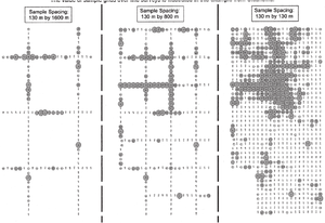
The recognition of surface geochemical anomalies improves by increasing sample number and reducing sample spacing. Figure 1, from Oklahoma, illustrates the value of geochemical grids over geochemical traverses for anomaly recognition.
See also
- Surficial geochemistry and hydrocarbon detection methods
- Surficial geochemical survey objectives
- Selecting a surficial geochemistry survey method
References
- ↑ 1.0 1.1 1.2 Matthews, M. D., 1996, Importance of sampling design and density in target recognition, in D. Schumacher and M. A. Abrams, eds., Hydrocarbon Migration and Its Near-Surface Expression: AAPG Memoir 66, p. 243–253.
- ↑ Horvitz, L., 1969, Hydrocarbon prospecting after thirty years, in W. B. Heroy, ed., Unconventional Methods in Exploration for Petroleum and Natural Gas: Dallas, Southern Methodist Univ. Press, p. 205–218.
- ↑ Schumacher, D., Hitzman, D., C., Tucker, J., Roundtree, B., 1997, Applying high-resolution surface geochemistry to assess reservoir compartmentalization and monitor hydrocarbon drainage, in Kruizenga, R., J., Downey, M., W., eds., Applications of Emerging Technologies: Unconventional Methods in Exploration for Oil and Gas V: Dallas, Texas, Southern Methodist Univ. Press, p. 309–322.
